Permian Basin and Pecos River Valley groundwater planning
A practical guide to the Pecos Valley Aquifer’s alluvial geology, highly variable water quality, irrigation history, groundwater districts, and the parcel-level checks that matter before buying land or drilling a well.
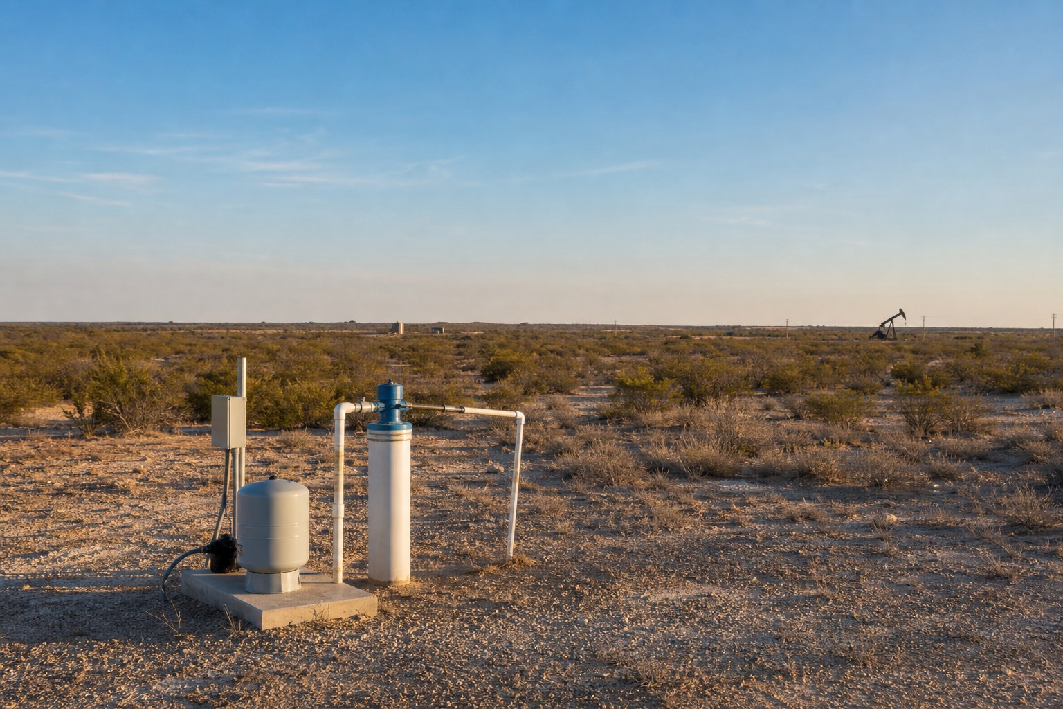
The Pecos Valley Aquifer looks straightforward on a state map: a major aquifer following the Pecos River Valley through far West Texas. On the ground, it is anything but uniform. The aquifer consists of alluvial and windblown sediments that fill several structural basins. Its two largest basins, the Pecos Trough in the west and the Monument Draw Trough in the east, do not offer the same water-quality story. Pumping history also differs from one local area to another. A useful property review has to identify which basin, which county, which nearby well uses, and which regulatory setting apply to the actual tract.
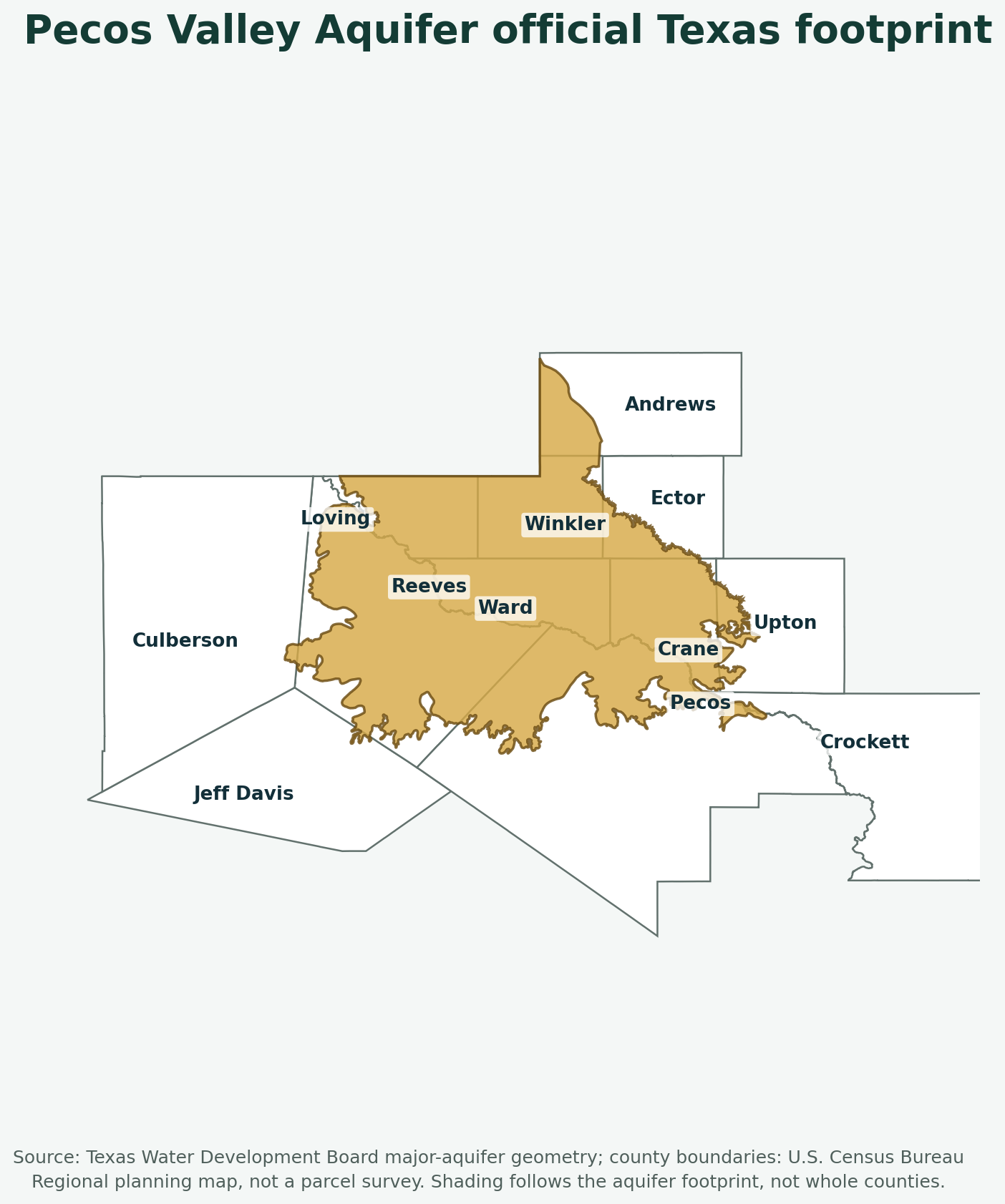
The official Texas Water Development Board Pecos Valley Aquifer summary classifies this as an unconfined major aquifer covering about 6,829 square miles in portions of 12 counties. TWDB reports that alluvial fill can reach 1,500 feet thick, while freshwater saturated thickness averages about 250 feet. Those numbers describe the aquifer as a regional system. They do not predict the depth, yield, chemistry, or cost of a well on one parcel.
This guide is for land buyers, rural homeowners, existing well owners, agents, lenders, and anyone trying to turn a regional aquifer name into a responsible property decision. It explains what the official sources do and do not establish, why water testing matters so much here, how irrigation and industrial demand affect the record, and which questions should be answered before a driller is asked for a tract-specific design.
Quick Facts About the Pecos Valley Aquifer
| Official aquifer fact | Practical meaning for a property owner |
|---|---|
| Aquifer type | Unconfined. Recharge and surface conditions can affect the shallow alluvial system, but the degree and timing vary locally. |
| Official extent | About 6,829 square miles in portions of 12 West Texas counties. |
| Groundwater district coverage | TWDB currently reports that about 47 percent of the aquifer is within groundwater conservation districts. The parcel must be checked rather than guessed from the county name. |
| Water-bearing material | Alluvial and windblown deposits in the Pecos River Valley, accumulated within structural basins. |
| Major structural basins | The Pecos Trough in the west and Monument Draw Trough in the east. |
| Regional thickness | Alluvial fill reaches as much as 1,500 feet, while freshwater saturated thickness averages about 250 feet. |
| Water quality | Highly variable and typically hard. TWDB says quality is generally better in Monument Draw Trough than in Pecos Trough. |
| Water-use pattern | More than 80 percent of groundwater pumped from the aquifer is used for irrigation. Remaining uses include municipal supply, industry, and power generation. |
| Important chemistry concerns | Chloride and sulfate can exceed secondary drinking-water standards. Naturally occurring arsenic and radionuclides can exceed primary standards. |
| Depth or yield guarantee | None. Regional thickness is not a parcel-specific drilling depth, and a nearby well is useful only after its location, use, completion, and date are understood. |
What the Pecos Valley Aquifer Actually Is
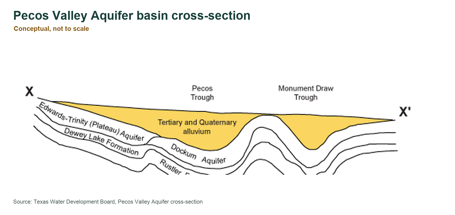
The Pecos Valley Aquifer is made of relatively young sediments deposited by water and wind. In older technical reports, readers may see the name Cenozoic Pecos Alluvium. The current TWDB public name is Pecos Valley Aquifer. Both labels point to the broad alluvial groundwater system laid into low areas above and beside older bedrock units.
That geology matters because an alluvial aquifer is not a single, clean slab of rock. Gravel, sand, silt, clay, caliche, and dune deposits can change over short distances. Coarser deposits may transmit water more readily, while finer layers may slow movement or divide the productive section. Two wells that appear close on a road map can encounter different sediment packages, different saturated thickness, and different water chemistry.
The TWDB Aquifers of Texas report shows the Pecos Valley deposits resting above several older formations and aquifers, including the Edwards-Trinity (Plateau) and Dockum in parts of the region. That stacked setting is another reason not to equate total hole depth with the thickness of usable Pecos Valley water. A driller may encounter more than one geologic unit, and a database record may identify the completed aquifer differently depending on the well’s construction and the available record.
For a buyer, the practical conclusion is simple: the aquifer name establishes regional context, not a construction plan. The parcel review still needs nearby well logs, screened or completed intervals when available, water-level information, use type, and current local drilling knowledge.
Pecos Trough and Monument Draw Trough Are Different Planning Stories
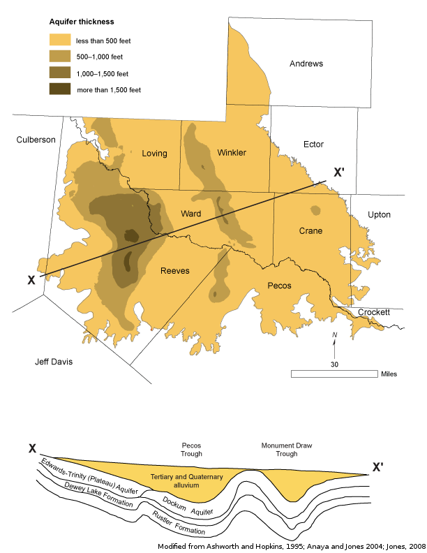
TWDB identifies the Pecos Trough and Monument Draw Trough as the largest structural basins filled by the aquifer’s sediments. The Pecos Trough lies to the west, while Monument Draw Trough lies to the east. This is more than map trivia. TWDB reports that water quality is generally better in Monument Draw Trough than in Pecos Trough, and that total dissolved solids in Monument Draw groundwater are usually below 1,000 milligrams per liter.
That statement still needs careful handling. A value below 1,000 milligrams per liter is not the same as a guarantee of ideal household water, and it does not address every contaminant. It describes a broad regional tendency. A particular well can differ because of its location, depth, construction, nearby land use, geologic pathway, and the history of the groundwater moving through that part of the basin.
The basin distinction is useful during an early land search because it gives the buyer a better question. Instead of asking, “Is this property on the Pecos Valley Aquifer?” ask, “Which part of the Pecos Valley system is this property in, and what do nearby same-use wells show there?” That second question is much closer to a budget and water-quality decision.
Why Aquifer Thickness Is Not the Same as Well Depth
The official figures can easily be misread. TWDB says the alluvial fill reaches 1,500 feet thick and freshwater saturated thickness averages about 250 feet. Neither figure should be copied into a drilling budget as the expected well depth. Total sediment thickness includes material that may not be saturated, may not transmit useful quantities of water, or may not contain water of suitable quality. Average freshwater saturated thickness compresses a varied regional system into one number.
A real well decision needs several separate measurements. Total well depth tells you how far the borehole was drilled. Static water level describes where water stood when measured. Pump setting tells you where the pump was installed. Screened or open intervals show where the well is designed to take in water. Yield describes performance under a particular test or operating condition. These fields are related, but none can substitute for the others.
Use type matters too. More than 80 percent of Pecos Valley pumping is for irrigation, according to TWDB. An irrigation well is designed around a different demand than a household well. Municipal, industrial, power-generation, stock, and monitoring records also answer different questions. A large irrigation or municipal well may be valuable evidence about the aquifer, but it should not become the automatic depth, pump, casing, or cost comparison for a rural residence.
The TurnkeyWells Free Well Check is a sensible first pass because it helps put nearby records on the map. The next step is to separate the records by distance, aquifer label, use, completion date, and available construction detail. The closest point is not always the best comparable.
Water Quality Is the Central Pecos Valley Due-Diligence Issue
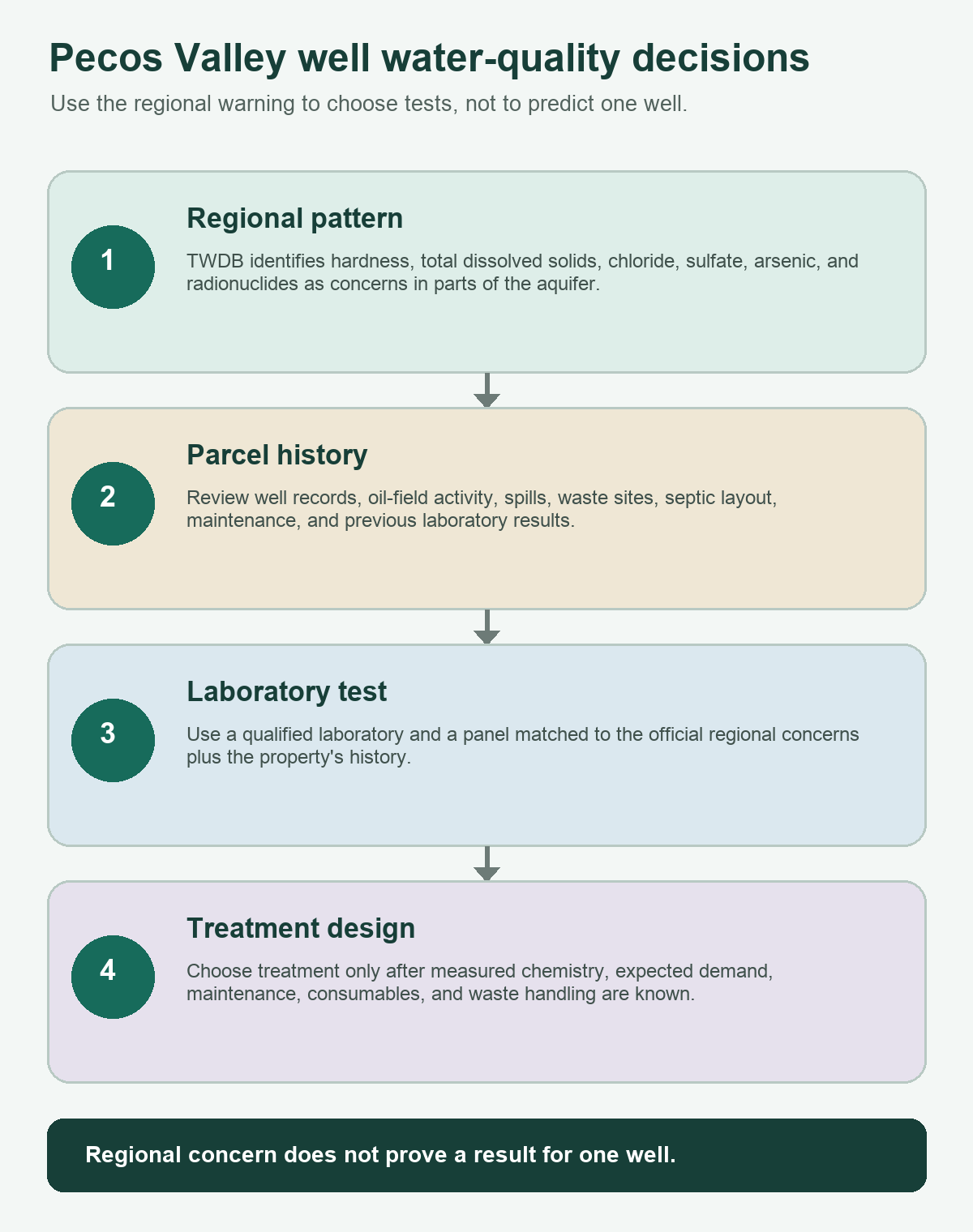
TWDB describes Pecos Valley groundwater quality as highly variable and typically hard. It also identifies elevated chloride and sulfate, sometimes above secondary drinking-water standards, associated with historic oil-field activities. Secondary standards generally address qualities such as taste, odor, appearance, and effects on plumbing or fixtures, but poor chloride and sulfate results can still create serious usability and treatment concerns for a household or agricultural operation.
The higher-consequence warning is that naturally occurring arsenic and radionuclides occur above primary drinking-water standards in parts of the aquifer. A regional warning does not prove that a specific well is contaminated. It does mean a buyer should not rely on clear appearance, acceptable taste, a seller’s memory, or a basic bacteria test as the entire water-quality review.
For an existing private well, testing should be designed around the property and the official regional concerns. A qualified laboratory or local health authority can help select the right panel. At minimum, the conversation should cover bacteria, nitrate, total dissolved solids, hardness, chloride, sulfate, arsenic, and radionuclides, along with any site-specific analytes suggested by nearby oil-field activity, known spills, waste sites, or previous results. Sampling technique and laboratory accreditation matter because a sloppy sample can produce a confident-looking result that does not answer the real question.
Water treatment should follow test results rather than lead them. A softener addresses hardness but is not a universal contaminant-removal system. Reverse osmosis, adsorption media, ion exchange, disinfection, and other treatment approaches solve different problems and create different maintenance obligations. A buyer needs the chemistry first, then a treatment design and operating budget matched to that chemistry.
How to read the water-quality warning without overreacting
- Do not assume the entire aquifer is unsafe. TWDB reports variability, not a uniform failure across 6,829 square miles.
- Do not assume a neighbor’s result proves yours. Well depth, screened interval, maintenance, and local pathways can differ.
- Do not stop at taste and hardness. Arsenic and radionuclides require laboratory analysis.
- Do not buy treatment before testing. Equipment should be selected for measured conditions and expected demand.
- Retest on an appropriate schedule. A private well is an owner-managed water supply, and conditions or well integrity can change.
Historic Oil-Field Activity Belongs in the Property Review
The Pecos Valley Aquifer sits in the Permian Basin, where oil and gas development is part of the land-use history. TWDB specifically connects high chloride and sulfate levels in the aquifer to previous oil-field activities. That does not establish a contamination claim against every tract near energy development, and it should not be used to draw a boundary around properties without supporting evidence. It does justify a more curious review of land history and nearby records.
For a tract with an existing well, ask whether there are historical water tests, changes in taste or scale, well repairs, abandoned wells, nearby pits, disposal activity, spills, or unexplained equipment on the property. Public regulatory records can add context, but the final decision should rely on parcel-specific inspection and laboratory evidence. An old plugged well or an industrial well on a map is not automatically proof of a current private-well problem. It is a reason to investigate rather than shrug.
This is also where a clean chain of documents matters during a sale. The driller report, maintenance receipts, pump details, treatment records, lab reports, district registration, and any relevant environmental records should be assembled before the inspection period disappears. A rural property with a functioning well is easier to value when the water system has a file instead of a legend.
Irrigation Dominates the Regional Pumping Story
More than four-fifths of groundwater pumped from the Pecos Valley Aquifer goes to irrigation. That agricultural history helps explain the large number of irrigation records and the importance of separating water use before comparing wells. It also explains why water-level trends cannot be summarized with one aquifer-wide arrow.
TWDB reports that localized water levels have rebounded in south-central Reeves County and northwestern Pecos County since the late 1970s as irrigation pumping decreased. At the same time, water levels continue to decline in central Ward County because of increased municipal and industrial pumping. These contrasting trends are a warning against generic claims that the entire aquifer is either recovering or declining.
For property planning, a historical rebound is encouraging but not a guarantee of future performance. A continuing decline is a serious planning signal but not a prediction that every nearby domestic well will fail. The correct question is how the local monitoring and nearby same-use record behave around the tract, and whether current demand, drought, and proposed use fit the available evidence.
Counties Within the Official Aquifer Footprint
The TWDB map shows the Pecos Valley Aquifer across portions of Andrews, Loving, Winkler, Ector, Ward, Crane, Upton, Crockett, Pecos, Reeves, Culberson, and Jeff Davis counties. County boundaries are useful for orientation, but they are not aquifer boundaries. A county can include multiple groundwater systems, and only a portion of the county may overlie the Pecos Valley Aquifer.
That caution is especially important at the edges. TurnkeyWells has a live guide to water well drilling in Andrews County, and its county record emphasizes Ogallala and Dockum context. The Pecos Valley footprint reaches only part of Andrews County. The county page is therefore a useful example of why a buyer should not assign an aquifer from the county name alone. Confirm the tract against the official aquifer map and nearby completed wells.
The same logic applies across the region. Reeves and Pecos counties are central to the Pecos Trough story. Ward County carries an important modern water-level warning. Loving, Winkler, Ector, Crane, and Upton sit in the broader Permian Basin setting, where industrial and oil-field records can complicate domestic comparisons. Culberson, Jeff Davis, and Crockett lie near edges where the relationship with neighboring geologic units deserves extra attention.
Groundwater Districts and Parcel-Level Rules
TWDB reports that approximately 47 percent of the aquifer lies within groundwater conservation districts. That means neither “the aquifer is regulated” nor “West Texas groundwater is unregulated” is an adequate answer. District jurisdiction must be checked for the exact parcel, and the applicable rules must be read in their current form.
A domestic or livestock well may qualify for an exemption in some districts, but exemption does not always mean no paperwork. Registration, spacing, location, construction, reporting, production, or transfer requirements can still apply. Larger irrigation, municipal, industrial, or commercial projects can face a different path. County and city requirements may matter in addition to groundwater-district rules.
Start with the TurnkeyWells Free GCD Lookup, then confirm the result with the district itself before drilling or relying on a seller’s summary. The safest order is jurisdiction first, nearby same-use records second, water-quality plan third, and driller design fourth. That sequence keeps a tract-specific rule or chemistry issue from arriving after the budget is already committed.
Verify the Parcel Before You Price the Well
The Pecos Valley Aquifer is too variable for a county average or a single neighboring record to carry the decision. Confirm the district, map the nearby wells, and build the testing plan before treating a drilling number as real.
Buying Land With an Existing Pecos Valley Well
An existing well can remove major uncertainty, but only when its condition and performance are documented. Ask for the state well report or driller log, total depth, completion interval, casing details, pump setting, pump age, pressure-system information, storage configuration, repair history, and recent laboratory results. If a field is blank, treat it as an unanswered question rather than filling it with a nearby average.
Then test performance. A short faucet demonstration proves that water reaches the house. It does not prove sustained yield, recovery, pressure under demand, or drought performance. A qualified well professional can evaluate the system in a way that fits the property and intended use. The test should distinguish the well from storage capacity, because a large tank can temporarily hide a weak or poorly recovering source.
Review the wellhead and surrounding land. Look for a sanitary cap, intact casing, positive drainage away from the well, safe separation from septic components and other contamination sources, protected electrical equipment, and a maintenance setup that can be serviced. In a region with historic oil-field activity, also note abandoned equipment, old pads, pits, stained soil, buried lines, and any land-use feature that warrants regulatory or environmental follow-up.
Finally, collect a current water sample through a qualified laboratory. The Pecos Valley’s documented variability makes chemistry a purchase issue, not a task to postpone until after closing. If treatment is proposed, request a written design, capital cost, maintenance schedule, consumables cost, and waste-stream plan. Cheap equipment with expensive upkeep is still expensive water.
Planning a New Pecos Valley Well
A new well should begin with tract-level evidence. Plot nearby wells and separate domestic or same-demand records from irrigation, municipal, industrial, power-generation, and monitoring wells. Review total depth, water level, completion, yield, and date where those fields exist. Older records can still be useful, but a record from a different pumping era or with no construction detail should carry less weight.
Next, ask a local licensed driller how the nearest reliable records translate to the site. Access, drilling method, casing, screen, gravel pack, sealing, development, test pumping, power, pump controls, storage, trenching, treatment, and site restoration all affect the finished cost. Footage alone is not a full well budget.
Build a water-quality allowance into the plan. In a highly variable aquifer with known regional chloride, sulfate, arsenic, and radionuclide concerns, testing and possible treatment are not decorative line items. They affect equipment space, plumbing layout, waste handling, maintenance, and the true monthly cost of operating the property.
For a higher-stakes land purchase or drill decision, the TurnkeyWells Pre-Drill Intelligence Report organizes the nearby record, aquifer context, and local risk into a more useful planning file. It does not guarantee groundwater conditions. It narrows the questions before a driller, laboratory, district, or engineer is asked to solve them.
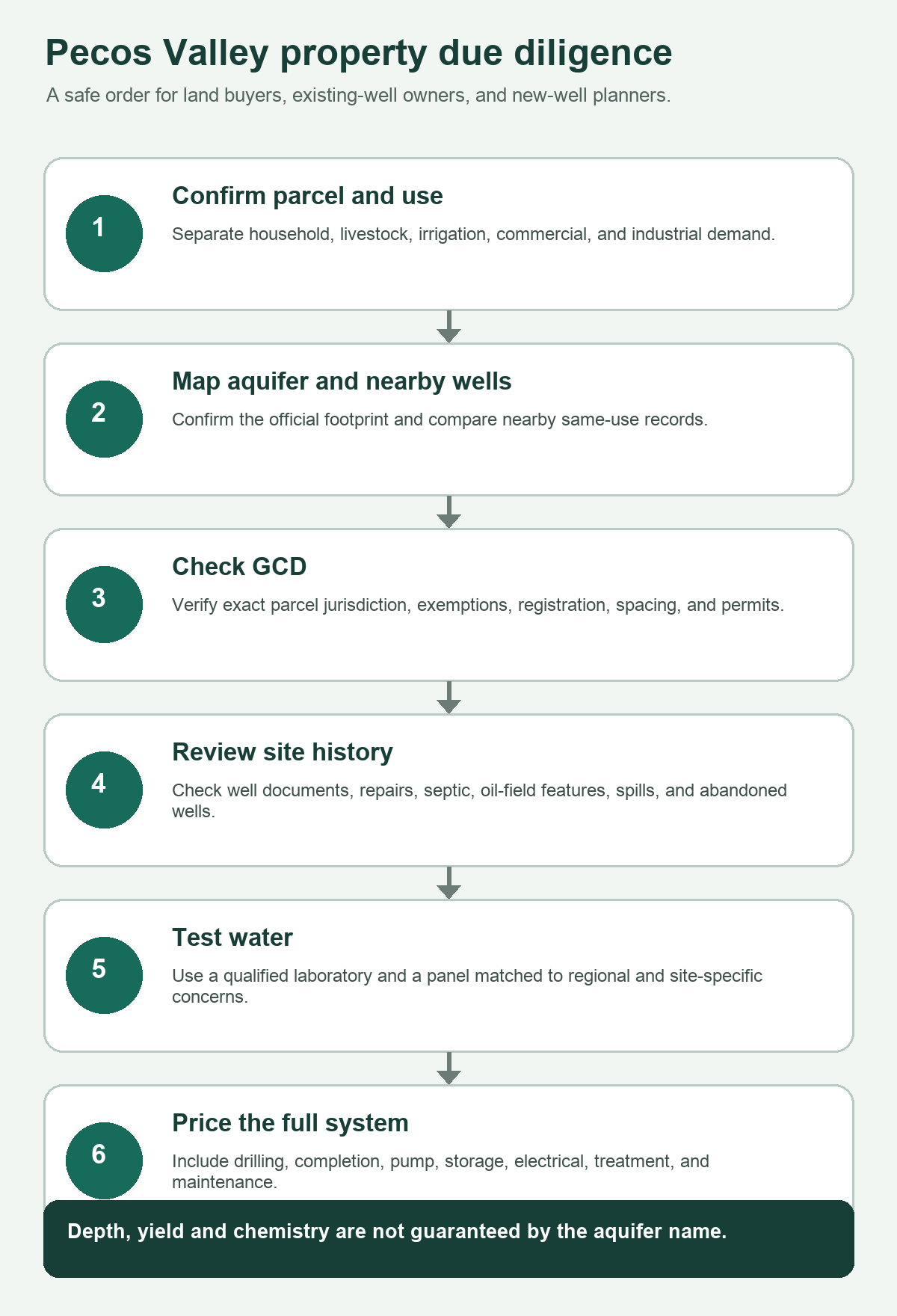
A Practical Pecos Valley Due-Diligence Sequence
- Confirm the parcel and intended water demand. Household, livestock, irrigation, commercial, and industrial projects should not share one comparison set.
- Check the official aquifer footprint. County presence alone does not prove the tract overlies the Pecos Valley Aquifer.
- Identify groundwater-district jurisdiction. Read current district requirements and confirm exemptions, registration, spacing, and permits directly.
- Map nearby wells. Separate same-use records from irrigation, municipal, industrial, and monitoring records.
- Review well construction and water levels. Do not reduce a log to total depth when completion and water-level fields are available.
- Investigate land-use history. Pay attention to oil-field infrastructure, abandoned wells, disposal activity, spills, septic systems, and drainage.
- Design the laboratory panel. Include the official regional concerns and any site-specific contaminants suggested by the property history.
- Get a full-system quote. Include drilling, casing, completion, pump, controls, storage, electrical work, trenching, testing, treatment, and maintenance.
- Plan for uncertainty. Keep contingencies for additional depth, alternate completion, water treatment, lower yield, and regulatory timing.
Frequently Asked Questions About Pecos Valley Wells
How deep is a typical Pecos Valley Aquifer well?
There is no honest single depth for the entire aquifer. TWDB reports that alluvial fill can reach 1,500 feet and freshwater saturated thickness averages about 250 feet, but those are regional aquifer measurements, not predicted well depths. A tract-specific estimate should come from nearby same-use logs, local geology, current water levels, and a licensed driller.
Is Pecos Valley Aquifer water safe to drink?
Some wells may provide usable household water, but the aquifer is highly variable. TWDB reports hard water, chloride and sulfate concerns, and naturally occurring arsenic and radionuclides above drinking-water standards in parts of the aquifer. Only a properly collected, current laboratory sample can answer the question for a specific well.
Is water better in Monument Draw Trough?
TWDB says water quality is generally better in Monument Draw Trough than in Pecos Trough, and total dissolved solids in Monument Draw are usually below 1,000 milligrams per liter. That is a regional pattern, not a guarantee for a parcel or well. Testing is still required.
Is the Pecos Valley Aquifer declining?
Local trends differ. TWDB reports rebound in south-central Reeves and northwestern Pecos counties after irrigation pumping decreased, while central Ward County continues to decline because of increased municipal and industrial pumping. Local monitoring and nearby well history are more useful than a single aquifer-wide label.
Do I need a permit to drill?
It depends on the exact parcel, district, proposed use, and current rules. TWDB reports groundwater-district coverage across about 47 percent of the aquifer. Even an exempt domestic or livestock well may face registration, spacing, construction, or reporting requirements. Use the GCD Lookup and confirm directly with the applicable authority.
Why are irrigation wells poor household comparisons?
Irrigation wells are designed around much larger and different demand. They may use different depth, diameter, completion, pump, power, and storage decisions. Since irrigation accounts for more than 80 percent of aquifer pumping, the regional record can be dominated by wells that do not represent a rural home’s needs.
What is the biggest mistake a Pecos Valley land buyer can make?
The biggest mistake is treating the aquifer name as a guarantee of depth, yield, or water quality. The safer approach is to confirm the mapped aquifer, compare nearby same-use wells, investigate land history, test the actual water, verify district rules, and price the complete system.
Turn Regional Groundwater Data Into a Property Decision
The Pecos Valley Aquifer is broad, layered, and chemically variable. Start with nearby wells and district jurisdiction, then move to a tract-specific report before you commit to land or drilling.
Farther west, the Hueco-Mesilla Bolsons Aquifer property guide covers a separate basin-fill system where El Paso-area public-supply history and fresh-to-brackish water boundaries shape the property review.
Official Sources and Limits
- Texas Water Development Board: Pecos Valley Aquifer. Current official summary for aquifer type, area, county count, groundwater-district coverage, geology, thickness, water quality, use, and localized water-level trends.
- Texas Water Development Board Report 380: Aquifers of Texas. Pecos Valley map, generalized cross-section, total-dissolved-solids map, hydraulic-conductivity map, and supporting aquifer discussion.
- Texas Water Development Board: Pecos Valley Aquifer cross-section. Official visual reference for the relationship among alluvial fill, the Pecos Trough, Monument Draw Trough, and underlying units.
- U.S. Environmental Protection Agency: Private Drinking Water Wells. General federal guidance on private-well owner responsibility, testing, maintenance, and contamination awareness.
This guide is a planning resource, not a parcel-specific hydrogeologic opinion, water-quality determination, legal interpretation, or drilling guarantee. Aquifer presence, well depth, yield, static water level, chemistry, treatment needs, district jurisdiction, and construction cost vary by property. Confirm decisions with the applicable groundwater district or local authority, a licensed water well driller, a qualified laboratory, and other appropriate professionals.