Far West Texas groundwater planning for El Paso and Hudspeth counties
The Hueco-Mesilla Bolsons Aquifer is a thick basin-fill system beneath a dry, fast-growing border region. Its name tells you the regional water source. It does not tell you the depth, chemistry, pumping history, or rule path for a specific property.
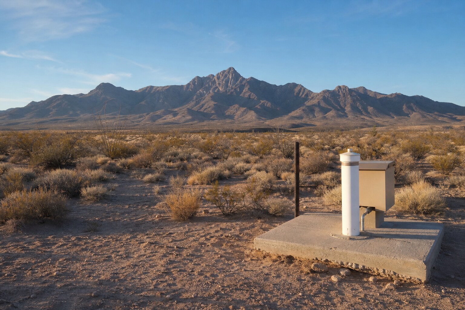
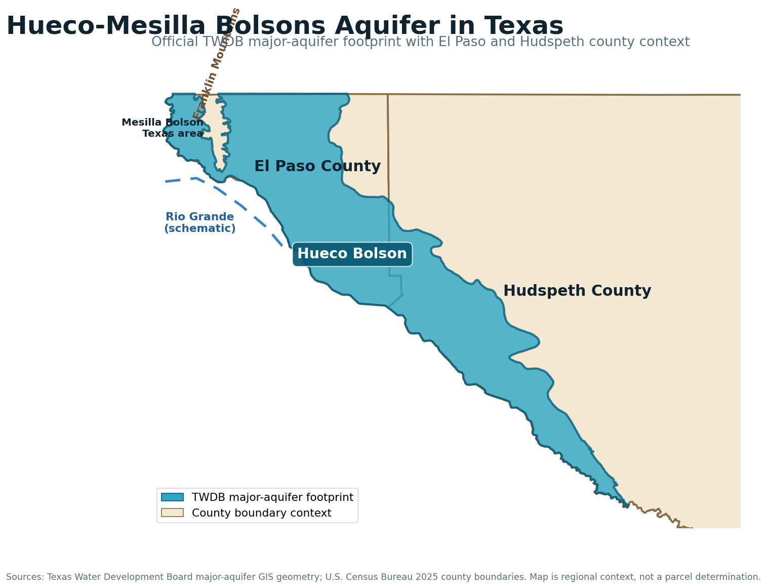
The Hueco-Mesilla Bolsons Aquifer covers about 1,376 square miles in Texas, all in El Paso and Hudspeth counties. It supplies water from silt, sand, gravel, and clay that accumulated in desert basins between mountain ranges. Nearly 90 percent of Texas pumping from the aquifer is for public supply, according to the Texas Water Development Board. That fact matters because the records around El Paso can be dominated by municipal demand, not by private domestic wells that make fair comparisons for rural acreage.
This is also a groundwater system with a long pumping history. TWDB reports that water levels in the Hueco Bolson declined several hundred feet because of historical municipal pumping, then observation wells showed stabilization after the late 1980s. That is not proof that every property has stable water levels today. It means buyers and owners should look at current local records instead of repeating an old regional headline in either direction.
The practical lesson is simple: confirm which bolson and which part of the basin a property occupies, separate public-supply records from domestic records, check the parcel’s regulatory setting, and test the actual water. The aquifer is too important, too variable, and too heavily used for a property decision based only on the word “Hueco” or “Mesilla.”
Hueco-Mesilla Bolsons Aquifer Quick Facts
- Formation type: Unconfined basin-fill aquifer made of silt, sand, gravel, and clay
- Texas extent: About 1,376 square miles
- Texas counties: El Paso and Hudspeth
- Maximum cited basin-fill thickness: About 9,000 feet in the Hueco Bolson and about 2,000 feet in the Mesilla Bolson
- Primary use: Nearly 90 percent of Texas pumping is for public supply
- Water-quality issue: Fresh groundwater is bordered by brackish-to-saline water, and chemistry varies by location and depth
- Private-well depth: No honest aquifer-wide number should be inferred from basin thickness. Use nearby same-use well records for the tract.
What Is the Hueco-Mesilla Bolsons Aquifer?
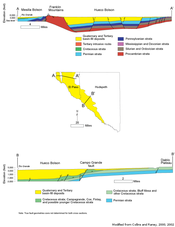
A bolson is a desert basin surrounded by higher ground. Over long periods, erosion moved sediment off the nearby mountains and deposited it in the basin. Those layers of gravel, sand, silt, and clay now store and transmit groundwater. Coarser sand and gravel zones can move water more readily. Fine silt and clay can slow movement and split the basin fill into locally different water-bearing zones.
The Texas aquifer includes the Hueco Bolson and the Texas part of the Mesilla Bolson. The two basins share a broad geologic story, but TWDB says they exchange little water. TWDB also says this aquifer is not hydraulically connected to another Texas major or minor aquifer. That makes comparison with a neighboring aquifer useful for regional perspective, but not as a substitute for evidence from the actual bolson.
The basin fill can be exceptionally thick. TWDB cites roughly 9,000 feet in the Hueco Bolson and 2,000 feet in the Mesilla Bolson. Those are geologic thickness figures, not a promise that a household well should be drilled anywhere near those depths. A private-well plan should come from local completed-well records, producing intervals, water quality, pumping levels, and the intended use.
Why This Aquifer Matters to El Paso and Far West Texas
Groundwater from the bolsons has supported public supply, homes, industry, and agriculture in one of the driest parts of Texas. The regional water story also crosses political boundaries. The same connected desert-basin setting extends around El Paso, Ciudad Juarez, and southern New Mexico, so pumping and recharge are larger than a single-county story even though the official Texas major-aquifer page focuses on the Texas portion.
That regional importance creates a comparison problem for private property. A deep, high-capacity public-supply well may be perfectly valid evidence about municipal infrastructure and still be a poor budget proxy for a domestic well. Nearly 90 percent public-supply pumping means the loudest numbers in a record search can come from a use type with different casing, capacity, treatment, and operating goals.
For a rural tract east of El Paso or in western Hudspeth County, the right question is not, “How deep is the aquifer?” The right questions are: Which completed domestic wells are closest? Which water-bearing intervals did they use? What do their driller logs and water tests show? How have pumping levels behaved locally? What district or county requirements apply to this parcel and this use?
Recharge and Groundwater Movement in a Desert Basin
Recharge in the Hueco-Mesilla setting is limited by the dry climate. Water can enter the basin fill along mountain fronts, through arroyos and stream channels during runoff events, and through interaction with the Rio Grande and managed water systems in parts of the region. The exact contribution changes by location and over time.
The aquifer’s layered basin fill matters because water does not move through every layer at the same speed. Gravel and sand can transmit water better than clay-rich zones. Pumping can also change local gradients. That is one reason a map showing an aquifer beneath a tract does not settle the question of usable water at a practical depth and acceptable quality.
The Hueco and Mesilla bolsons also should not be treated as one tank. TWDB’s statement that little water moves between them is a direct warning against carrying a record from one basin to a property in the other without checking its relevance.
Well Depth and Yield: Use the Local Record, Not Basin Thickness
The official aquifer profile gives maximum formation thickness, but it does not provide one truthful private-well depth for every tract. A 9,000-foot basin does not mean a household well should be 9,000 feet deep. It means the sedimentary basin is geologically deep. Actual wells target a usable interval based on location, water level, water quality, intended pumping rate, construction design, and local experience.
Public-supply, industrial, irrigation, and domestic wells should be separated before calculating any local comparison. Municipal wells may be deeper, larger, or completed across different intervals than a household system. Domestic wells can also vary sharply between the El Paso urban fringe, the east side of the Franklin Mountains, and sparse Hudspeth County acreage.
| Planning area | What the regional evidence says | What a property owner still needs |
|---|---|---|
| Hueco Bolson, El Paso County | Major public-supply use and a documented history of substantial water-level decline from municipal pumping | Nearby domestic records, current pumping-level evidence, water chemistry, and parcel-specific rules |
| Texas part of the Mesilla Bolson | Thinner maximum cited basin fill than Hueco and limited groundwater exchange with Hueco | Records from the Mesilla side, not a borrowed Hueco average |
| Hudspeth County portion | Sparse desert setting with basin-fill groundwater and fresh-to-saline variation | Same-use records close to the tract, access planning, testing, storage, and district confirmation |
A Free Well Check is the broad first pass for registered wells near the address. A Pre-Drill Intelligence Report is the better next step when the property is under serious consideration and the comparison set needs to be filtered by distance, use, depth, and local context.
Water Quality: Fresh Water Has a Boundary
TWDB describes fresh groundwater in the aquifer as bordered by brackish-to-saline water. That boundary is a property-planning issue, not a footnote. In the Mesilla Bolson, salinity can increase southward and can be higher in shallower zones. In the broader basin-fill system, water quality can change with depth, location, flow path, and pumping history.
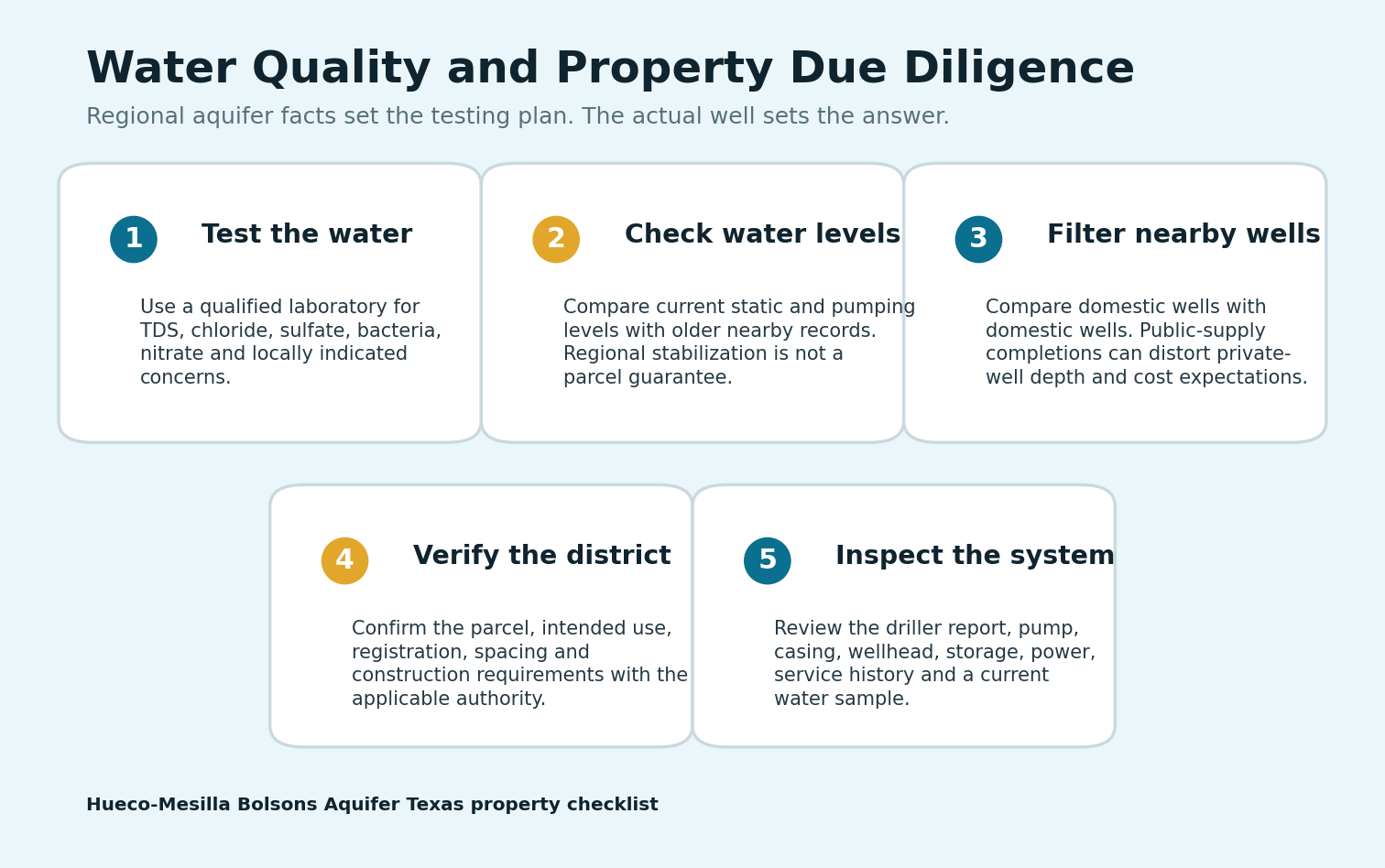
Total dissolved solids, chloride, and sulfate help describe whether water is fresh, mineralized, or moving toward brackish conditions. A private-well buyer should also test the health and household basics: total coliform and E. coli, nitrate, pH, hardness, iron, manganese, and any local contaminant identified by nearby records or regulators. No regional aquifer guide can certify the water from an individual well.
For an existing well, collect a current laboratory sample and compare the results with the well’s construction and service history. For a new well, ask the driller which nearby completions produced usable water, whether deeper or shallower zones show chemistry problems, and how the proposed casing and screen plan addresses the local formation.
Water-Level History: Decline, Response, and the Limits of a Regional Trend
Historical pumping lowered Hueco Bolson water levels by several hundred feet in some areas. TWDB also reports that observation wells indicated stabilization after the late 1980s. Both facts belong in the same sentence. Quoting only the decline makes the current story sound frozen in the past. Quoting only stabilization can hide the scale of earlier stress and the possibility of local differences.
For buyers, the useful evidence is current and local. Ask for static and pumping water levels when available. Compare older and newer nearby records. Look for changes in pump setting, declining production, well deepening, or replacement. A regional trend can frame the question. It cannot answer whether one existing well will support a home through the next dry cycle.
Groundwater Districts and Property-Level Rules
Do not assume that every parcel in El Paso and Hudspeth counties follows one groundwater rulebook. District boundaries, exempt-well provisions, registration, spacing, production limits, and construction requirements can differ by location and use. Municipal history also does not tell a rural property owner what applies to a domestic well.
Start with the Free Texas GCD Lookup for the exact address. Then confirm the result with the applicable district, county, and licensed driller before construction. Even when a domestic or livestock exemption applies, registration, spacing, well-log filing, or sanitary construction rules can still matter.
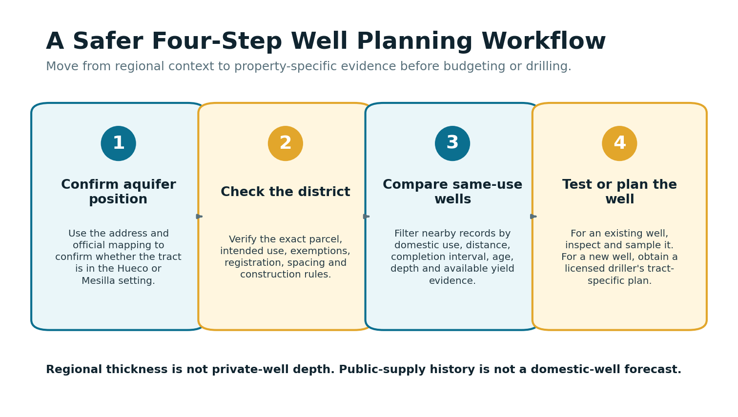
The safe order is district check, nearby same-use records, water-quality context, site access and utilities, then a driller’s construction proposal. A verbal depth estimate given before those checks is not due diligence.
Buying Property With an Existing Well
An existing well can add real value in Far West Texas because replacing it can involve drilling, pump equipment, storage, power, treatment, and long mobilization distances. That value depends on evidence. Ask for the driller report, pump information, repair records, recent lab results, and any available static and pumping water-level measurements.
Inspect the wellhead and the system around it. Look for a secure sanitary cap, casing condition, drainage away from the well, protected electrical components, serviceable pressure equipment, and a storage setup that matches the property’s needs. Remote acreage may depend on storage or backup power as much as raw well yield.
If the seller cannot produce records, do not fill the gap with assumptions. Search the public file, compare the apparent construction with registered records, test the water, and have a qualified professional inspect the system. For a Texas transaction involving groundwater, organize those findings before disclosure and closing pressure take over.
Planning a New Well in El Paso or Hudspeth County
A new-well plan should begin with the tract, not the aquifer headline. Pull nearby domestic wells. Separate them from public-supply and irrigation records. Check which bolson the property occupies. Review water-level and chemistry clues. Confirm the district and the intended-use rules. Then ask a licensed driller to explain the proposed target interval, casing program, pump setting, expected testing, and contingency plan.
Do not budget from footage alone. Far West Texas projects can carry meaningful costs for access, mobilization, trenching, power, storage, treatment, and service distance. A shallower well on a difficult remote site can still become a serious project. A deeper well near infrastructure can have a different cost profile.
TurnkeyWells provides the public-record and property-intelligence layer. It does not replace a driller, laboratory, engineer, or regulator. The point is to reach those professionals with better questions and fewer expensive assumptions.
Counties on the Hueco-Mesilla Bolsons Aquifer
The official Texas major-aquifer extent is limited to El Paso County and Hudspeth County. TurnkeyWells does not currently have verified live county pillars for either county, so they remain plain text here until those county pages are published and visually checked. This avoids sending readers to an invented URL or an unrelated county.
For a verified regional comparison outside this aquifer, see the Brewster County private-well guide. Brewster County belongs to a different mix of Trans-Pecos groundwater settings, so its depth data should not be used as a Hueco-Mesilla proxy.
How Hueco-Mesilla Compares With Other Texas Aquifers
The Pecos Valley Aquifer is another West Texas basin-fill system, but it is a separate aquifer with different geography, water movement, and local records. The Edwards-Trinity Plateau Aquifer covers a much broader plateau and ranch-country setting. The Ogallala Aquifer is the High Plains system whose saturated-thickness decline and irrigation history create a different planning problem.
Those guides are useful for understanding how Texas aquifers differ. They are not substitutes for Hueco-Mesilla evidence. TWDB specifically says the Hueco-Mesilla Bolsons Aquifer is not hydraulically connected to another Texas major or minor aquifer.
Check the Property Before You Trust a Regional Average
Far West Texas well decisions turn on local records, water quality, pumping history, and the tract’s rule setting. Start with the address, then build a comparison set that matches the intended use.
Frequently Asked Questions About the Hueco-Mesilla Bolsons Aquifer
How deep is a typical private well in the Hueco-Mesilla Bolsons Aquifer?
There is no responsible aquifer-wide private-well depth in the official profile. The basin fill reaches a maximum cited thickness of about 9,000 feet in Hueco and 2,000 feet in Mesilla, but those are geologic thickness figures, not household well-depth estimates. Use nearby domestic well records and a tract-specific driller review.
Which Texas counties are over the aquifer?
The official Texas extent is in El Paso and Hudspeth counties. The regional basin setting continues across state and international boundaries, but the Texas Water Development Board’s major-aquifer designation discussed here covers the Texas portion.
Is Hueco-Mesilla groundwater fresh?
Some groundwater is fresh, but fresh zones are bordered by brackish-to-saline water. TWDB notes that salinity can increase southward and in shallower Mesilla zones. Test the actual well for TDS, chloride, sulfate, bacteria, nitrate, and other tract-specific concerns.
Are the Hueco and Mesilla bolsons hydraulically connected?
They share a geologic origin, but TWDB says little water moves between them. A well record from one bolson should not be treated as a direct comparable for a tract in the other without local evidence.
Why do public-supply wells matter when evaluating a private well?
Nearly 90 percent of Texas pumping from the aquifer is for public supply. Those wells can dominate regional discussions and record sets, but their construction and pumping goals may be very different from a household well. Filter comparisons by use before using them for depth or budget planning.
Have water levels stopped declining?
TWDB reports historical declines of several hundred feet in the Hueco Bolson and says observation wells indicated stabilization after the late 1980s. That regional history does not guarantee the condition of one property. Review current nearby records and measurements where available.
Do I need a groundwater permit for a domestic well?
It depends on the exact parcel, district status, intended use, and well design. A domestic or livestock exemption may apply in some places, while registration, spacing, construction, or reporting requirements can still remain. Start with the Free Texas GCD Lookup and confirm with the applicable authority.
Sources and Fact Notes
- Texas Water Development Board, Major Aquifers: TWDB official major-aquifer overview
- Texas Water Development Board, Hueco-Mesilla Bolsons Aquifer profile: TWDB Hueco-Mesilla Bolsons Aquifer profile
- U.S. Geological Survey, Fact Sheet 2007-3056: USGS Fact Sheet 2007-3056
This guide uses official regional aquifer information for planning. Well depth, producing interval, yield, pumping level, water chemistry, construction requirements, and permitting vary by property. Verify the tract with local records, a qualified laboratory, a licensed Texas water well driller, and the applicable regulatory authority.