West Texas plateau groundwater planning
The Edwards-Trinity Aquifer in Texas
A practical guide to Edwards Plateau well depth, water quality, irrigation pressure, groundwater district rules, and what the local Texas well record says before you buy land or drill.
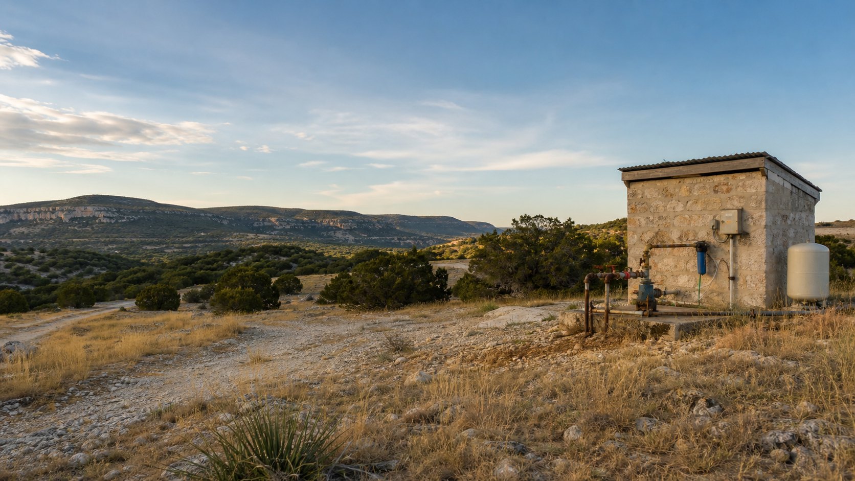
The Texas Water Development Board calls this aquifer the Edwards-Trinity (Plateau) Aquifer. For property owners, the useful point is not the punctuation. It is the geography and the rock. This is the big groundwater system beneath much of the Edwards Plateau and adjoining West Texas country, where ranch wells, stock wells, irrigation projects, hunting tracts, and scattered rural homes all depend on a mix of fractured Edwards limestone, dolomite, and Trinity sands.
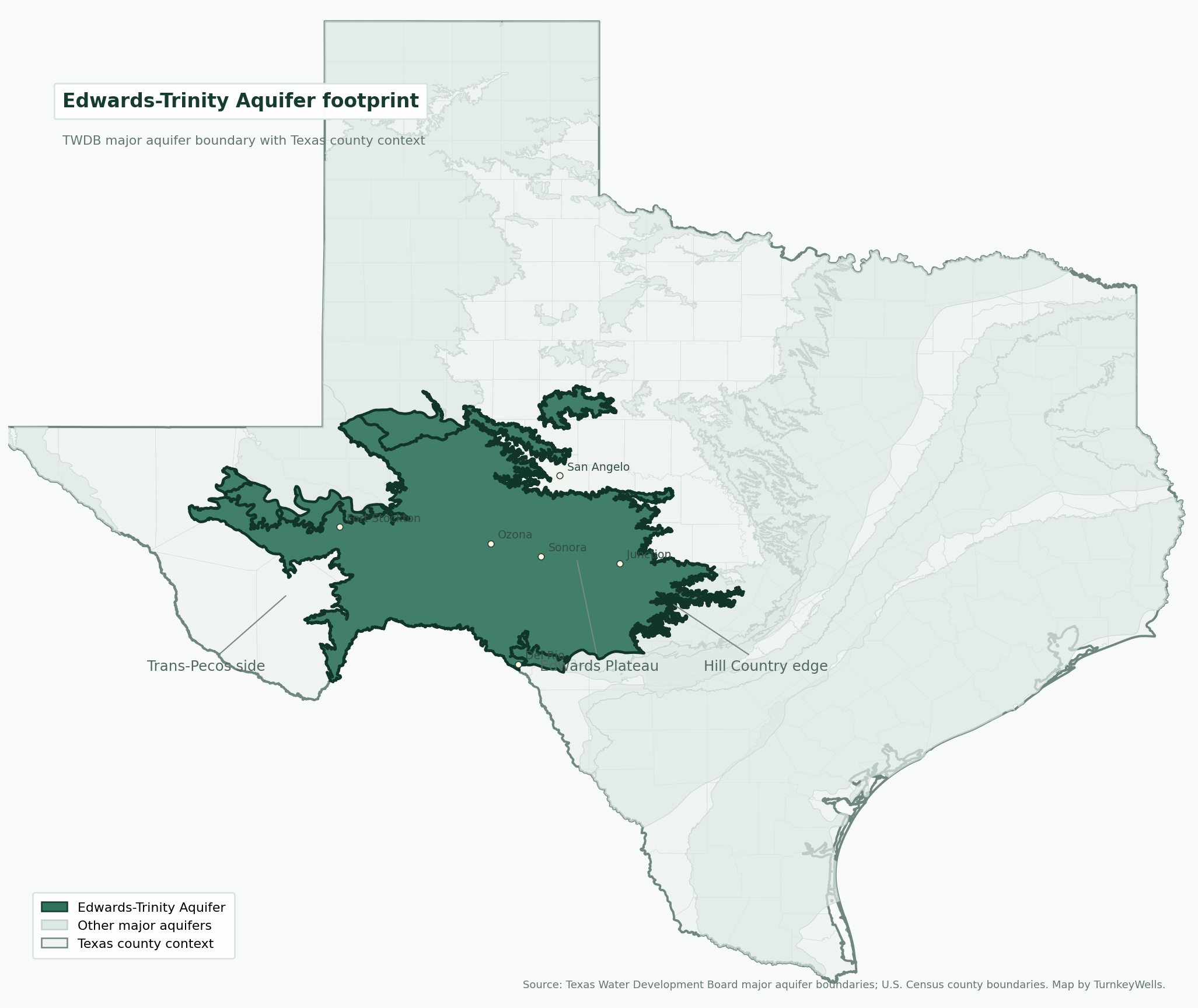
If you are evaluating land anywhere from the Hill Country edge through Menard, Kimble, Edwards, Sutton, Crockett, Schleicher, Val Verde, Pecos, Reagan, Glasscock, or the Trans-Pecos side of the footprint, the Edwards-Trinity question usually shows up before the contract is dry. How deep are the wells? Is the water hard? Is the district active? Does a shallow stock well tell me anything about a full-time house? Can I trust an old irrigation claim? Those are the questions that change a land deal from easy to expensive.
This page is built for buyers, sellers, ranch owners, agents, and rural property decision-makers who need something better than a generic geology label. It pulls together current TWDB aquifer facts, official footprint counts, and the TurnkeyWells local database so you can see how the Edwards-Trinity behaves in the real world: where the fresh section is thick, where the chemistry changes, why irrigation matters, and how our tools help before you sink money into the wrong assumption.
Quick Facts About the Edwards-Trinity Aquifer in Texas
| Planning Item | Practical Property Owner Meaning |
|---|---|
| Official TWDB designation | Edwards-Trinity (Plateau) Aquifer, a major Texas aquifer |
| Aquifer type | Mostly unconfined with small confined areas, built from Edwards Group limestone and dolomite plus Trinity Group sands |
| Texas extent | 41 counties, with 32,373 square miles of outcrop and 3,051 square miles of subsurface extent according to TWDB |
| Groundwater district coverage | About 82 percent of the aquifer sits inside groundwater conservation district jurisdiction |
| Saturated thickness | Less than 100 feet in the north and more than 800 feet down-dip to the south; freshwater saturated thickness averages 433 feet on the TWDB summary |
| TurnkeyWells exact tagged records | 12,563 GWDB wells tagged exactly Edwards-Trinity Plateau, with 9,669 usable depth values |
| TurnkeyWells submitted driller records in the official footprint | 53,478 well reports and 12,129 plugged-well records inside the TWDB Edwards-Trinity polygon |
| Typical tagged depth signal | 146 to 342 feet for the middle half of the tagged sample, with a 230-foot median and a 450-foot 90th percentile |
| Water quality baseline | Generally hard calcium bicarbonate water; total dissolved solids commonly run 400 to 1,000 mg/L in fresh portions, with salinity increasing westward and in deeper confined sections |
| Pumpage reality | TWDB says more than two-thirds of water pumped from the aquifer goes to irrigation, with the rest largely municipal and livestock use |
What the Edwards-Trinity Aquifer Actually Is
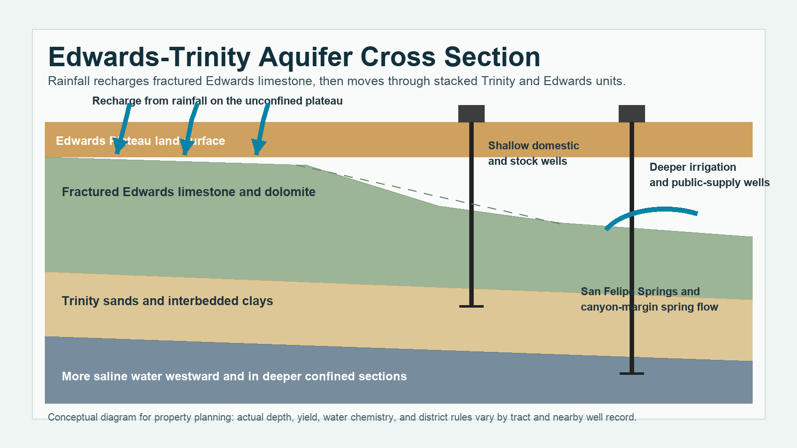
The Edwards-Trinity is not a one-layer tank. It is a stacked carbonate and sand system dominated by limestone and dolomite from the Edwards Group with Trinity sands beneath or alongside it, depending on where you are in the footprint. In plain English, some properties sit over fractured limestone that can move water quickly through cracks, solution openings, and karst pathways. Other properties depend more on Trinity sands and mixed intervals that behave differently under pumping stress.
That mixed geology is why the aquifer can support everything from shallow stock wells and ranch improvements to deeper irrigation wells and public-supply projects. The official TWDB summary says the aquifer is mostly unconfined with small confined areas. That matters because the unconfined sections recharge more directly from rainfall over the plateau, while confined sections and western Trinity-heavy zones can behave more slowly and often show saltier water chemistry.
The Edwards Plateau is also a major karst landscape. Fractures, sink-like features, caves, and solution channels are part of the groundwater story. For a property owner, the practical translation is simple. Water can be productive and reliable, but it can also move through rock in ways that make local evidence far more important than a broad county average. A tract with nearby strong wells can be a completely different proposition from a tract a few miles away where the fresh section thins out or the chemistry shifts.
The History of the Edwards-Trinity in Texas
Long before the modern well registry existed, springs coming off the Edwards-Trinity helped define where people and livestock could stay alive in this part of Texas. Ranching and settlement on the plateau were tied to groundwater and spring flow, not just because surface streams were inconsistent, but because the plateau is big, dry, and unforgiving when you guess wrong about water. San Felipe Springs near Del Rio is the headline example, but the aquifer historically fed many smaller springs along its margins and across canyon country.
Drilling technology changed the economics of the plateau. Hand-dug or shallow early wells gave way to drilled ranch and stock wells, then to bigger municipal and irrigation projects as equipment improved. The official TWDB aquifer summary notes that spring flows in the western portion of the aquifer have declined where irrigation pumping increased. That is the important historical pivot for modern land buyers: the aquifer is not a frozen system. Human demand has already changed how parts of it behave.
Groundwater districts are the other major historical milestone. As more of the plateau moved under formal groundwater management, the land game changed from “can a driller hit water” to “what does the district require and what does the nearby record really show.” Today about 82 percent of the aquifer lies within district coverage. That means old stories about a grandfathered stock well or a famous irrigation well matter less than current jurisdiction, current well logs, and current use-based expectations.
What TurnkeyWells Records Show About Edwards-Trinity Well Depth
The cleanest local count comes from the exact GWDB tag. TurnkeyWells has 12,563 wells tagged exactly Edwards-Trinity Plateau, and 9,669 of those records carry a usable depth value. Across that usable sample, the average recorded depth is 275 feet and the median is 230 feet. The middle half of the sample runs from roughly 146 feet to 342 feet, while the 90th percentile reaches about 450 feet.
The aquifer footprint is bigger than the exact tag count. When TurnkeyWells runs the official TWDB Edwards-Trinity polygon across the submitted driller report database, it finds 53,478 submitted driller reports and 12,129 plugged-well records inside the footprint. Those are geographic counts, not confirmed completion-name counts, but they matter because they show how much drilling and well turnover has actually happened across the plateau.
The tagged use mix also helps explain why buyers get confused. In the exact tagged sample, stock wells are the biggest bucket with 4,435 usable depth records and a 201-foot median. Domestic wells show 2,067 usable depth records with a 215-foot median. Irrigation wells show 906 usable depth records with a 300-foot median. Public-supply wells sit close to that with a 303-foot median. TWDB still says more than two-thirds of groundwater pumped from the aquifer goes to irrigation. Both statements can be true at once because a smaller number of big irrigation wells can move far more water than a larger number of scattered stock or domestic wells.
That distinction matters on a live deal. A ranch seller may quote the depth of the stock well that serves troughs and hunting blinds. That tells you something useful. It does not automatically tell you what a new full-time residential well, a subdivision well, or a higher-demand irrigation project will require. On the Edwards-Trinity, well use matters almost as much as county.
Representative County Depth Table
| County | Tagged depth sample | Average / median depth | Dominant use in tagged sample | Planning read |
|---|---|---|---|---|
| Concho County | 207 tagged depth records | 91 ft avg / 85 ft median | Stock | Shallower stock-and-domestic signal. Good reminder that some eastern plateau tracts are more manageable than the western reputation suggests. |
| Tom Green County | 273 tagged depth records | 143 ft avg / 121 ft median | Stock | Still comparatively shallow, but use-specific comparisons matter if the property is moving from ranch support to full-time residential demand. |
| Menard County | 642 tagged depth records | 170 ft avg / 160 ft median | Stock | Plateau ranch-country depth profile. A practical domestic benchmark, but still not a quote for every tract. |
| Kimble County | 521 tagged depth records | 194 ft avg / 187 ft median | Stock | Strong Hill Country edge example where stock and domestic wells dominate the planning conversation. |
| Schleicher County | 704 tagged depth records | 316 ft avg / 346 ft median | Stock | Deeper than the eastern edge and heavily ranch-oriented. Depth and casing assumptions should be more conservative here. |
| Edwards County | 461 tagged depth records | 350 ft avg / 335 ft median | Stock | A good example of the recharge-to-confined transition. Local depth can move fast over short distances. |
| Sutton County | 422 tagged depth records | 281 ft avg / 284 ft median | Stock | Classic central plateau mixed-demand county where a stock-well story may not fully price a new household project. |
| Crockett County | 463 tagged depth records | 401 ft avg / 400 ft median | Stock | A deeper western county. Budget and chemistry both deserve more skepticism before drilling. |
| Val Verde County | 500 tagged depth records | 568 ft avg / 429 ft median | Stock | One of the deeper tagged county signals, with spring history and western water-quality questions both in play. |
| Pecos County | 513 tagged depth records | 406 ft avg / 320 ft median | Stock | Western irrigation and stock context. A good place to separate big-water stories from practical domestic planning. |
The spread in that table is the point. Concho and Tom Green can read much shallower than Val Verde, Crockett, Pecos, or the deeper western side of the footprint. Menard and Kimble can look manageable for ranch-house planning, while the deeper counties make you respect casing, pump setting, and treatment costs sooner. There is no honest single-number answer for the whole aquifer.
What Those Depths Mean for a Real Property Decision
If you are buying land with an existing well, ask which interval it targets, how old the pump is, where the pump is set, whether the well has been cleaned or rehabbed, and whether anyone has a recent pump test. A 180-foot well on the plateau can be a great domestic asset. It can also be an old stock well that has never been asked to serve a full-time house, filtration system, irrigation line, and guest cabin. The registry depth alone does not tell you current performance.
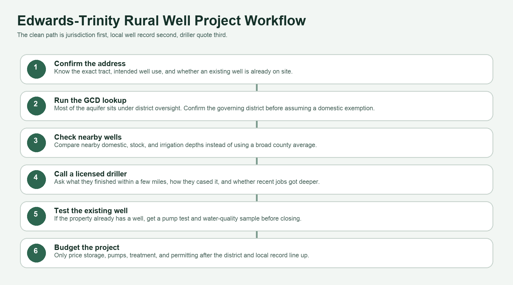
If you are drilling a new well, the safest sequence is local record first, district second, driller third, budget last. Pull the nearby wells, sort them by use, then decide whether your tract is behaving like the shallower ranch corridor or the deeper western corridor. That is where TurnkeyWells earns its keep. We can help you separate the useful nearby comparisons from the wrong well stories that travel around every rural county coffee shop.
Water Quality on the Edwards-Trinity
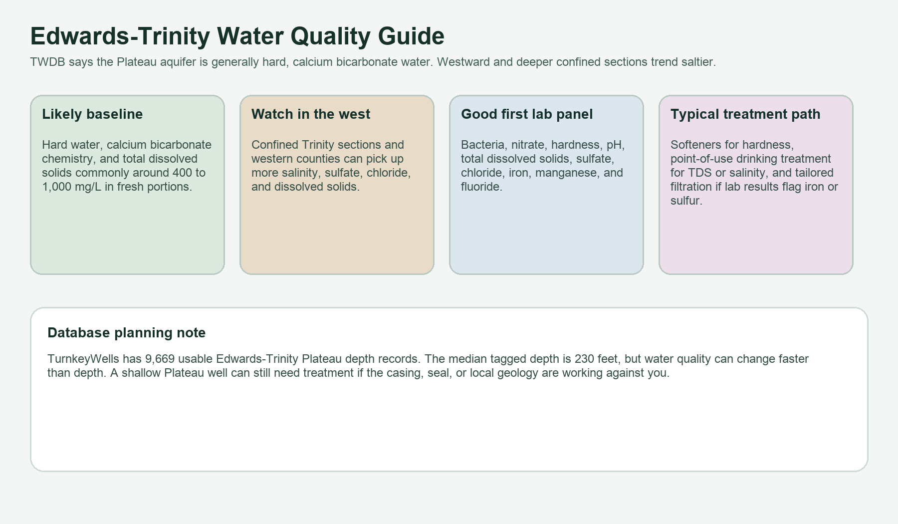
The official TWDB summary describes the aquifer water as generally hard, calcium bicarbonate type water. It also says total dissolved solids typically range from 400 to 1,000 milligrams per liter in the fresh portion. For a property owner, that translates into a familiar West Texas checklist: scale on fixtures and heaters, possible taste issues as dissolved solids climb, and more salinity risk the farther west you go or the deeper and more confined the water becomes.
TWDB also notes that the unconfined portion of the aquifer is generally fresh, with only small localized areas of slightly saline groundwater. Westward and in the confined Trinity-heavy zones, salinity usually increases. The older TWDB hydrologic atlas on this aquifer also flagged sulfate, chloride, fluoride, and dissolved-solids trouble spots, especially in the west and northwest parts of the study area. That is why the right water-quality question is never just “is Edwards-Trinity water good.” The right question is “what does this actual well test show on this actual tract.”
Hardness is often the first practical issue because it shows up in daily living. You see it on faucets, heater elements, and plumbing. Dissolved solids matter for taste and long-term equipment life. Chloride and sulfate can become more noticeable in western or deeper confined sections. Fluoride can be worth testing in areas where older TWDB sampling flagged it. Bacteria and nitrate should still be in the test panel for any domestic well even if the aquifer name sounds reassuring.
Treatment should follow the lab, not the rumor. A softener may solve the hard-water problem. It will not fix bacteria. A point-of-use drinking treatment system may help with elevated dissolved solids or taste, but it is not the same thing as whole-house conditioning. If a tract already has a well, get the sample before closing if the water matters to the deal. If you are drilling a new well, test immediately after completion before you buy equipment you do not need.
Groundwater Districts and Permitting
District oversight is not a side issue on the Edwards-Trinity. TWDB says about 82 percent of the aquifer lies inside groundwater conservation district coverage, and a property owner ignores that at his own expense. A domestic or livestock exemption can still involve registration, spacing requirements, or notice rules. Higher-volume irrigation, commercial, or public-supply projects can face permits, production limits, or reporting obligations that materially change the project timeline.
Representative districts across the aquifer include the Middle Pecos Groundwater Conservation District, Sutton County Underground Water Conservation District, Crockett County Groundwater Conservation District, Kinney County Groundwater Conservation District, Menard County Underground Water District, and Real-Edwards Conservation and Reclamation District. This is not a full district map and it is not legal advice. It is a reminder that the aquifer is too large and too actively managed to treat permitting as an afterthought.
The clean first move is still the same on every tract: run the Free GCD Lookup before you assume anything about exemptions, spacing, or allowed use. Then compare the district result to the nearby well record. If the tract already has a well, confirm whether the existing use matches what you are planning. Changing a ranch-use assumption into a higher-demand residential or irrigation project is where sloppy groundwater planning starts to cost money.
Check the District Before You Drill
Plateau projects go sideways when buyers rely on an old well story instead of the actual district and nearby record. Start with the governing district, then pull the local wells, then price the project.
Counties and Regions in the Edwards-Trinity Footprint
TWDB says 41 counties contain the aquifer. TurnkeyWells is not going to force wrong county links here just to fill space. Our clean published county-page set is still weighted toward other aquifer corridors, so this hub lists key plateau and Trans-Pecos regions in plain text until the matching county pages are genuinely ready and verified.
Hill Country and eastern plateau edge
Gillespie, Kerr, Kimble, Menard, Real, Edwards, and nearby ranch counties sit on the more familiar eastern side of the system where plateau recharge, stock wells, and mixed ranch-residential planning dominate the conversation.
Central plateau ranch corridor
Schleicher, Sutton, Crockett, Irion, Reagan, Concho, and Tom Green counties reflect the middle of the plateau story: ranch, hunting, stock water, scattered domestic demand, and deeper variability as you move west.
Western and Trans-Pecos side
Val Verde, Pecos, Reeves, Glasscock, Midland, Upton, and neighboring western counties bring the harder irrigation and salinity questions into play. A tract in this corridor deserves more skepticism about depth, chemistry, and long-term pumping assumptions.
How the Edwards-Trinity Compares to Nearby Texas Aquifers
The Edwards-Trinity is not the same planning problem as the Trinity Aquifer around DFW. The Trinity page is a better fit when the tract sits in North Texas limestone-and-sandstone country with a different county mix and a different recharge pattern. It is also not the same story as the Ogallala Aquifer, where unconfined High Plains depletion and saturated-thickness decline drive the conversation. And it is definitely not the same chemistry or coastal risk picture as the Gulf Coast Aquifer.
That comparison helps when buyers jump between regions and assume a Texas well is a Texas well. It is not. The Edwards-Trinity is its own lane: hard carbonate water, major ranch and livestock relevance, a real irrigation footprint, spring history along the margins, and a district-heavy permitting map across a broad plateau and Trans-Pecos corridor.
For Far West Texas properties closer to El Paso and Hudspeth counties, the Hueco-Mesilla Bolsons Aquifer guide explains a different basin-fill setting with heavy public-supply use, distinct bolsons, and property-specific water-quality questions.
What This Means for an Existing Well on a Ranch or Homesite
An existing Edwards-Trinity well can be a strong asset, but only if you know what it is. Many rural properties in this corridor have stock wells that were never designed to carry a full-time house with modern plumbing, irrigation zones, water softening, and guest use. Others have old domestic wells that still work but have never had a recent lab test or pump test. If the well matters to the purchase, treat it like real infrastructure and inspect it that way.
That means asking for the TWDB record if it exists, checking the depth, pump setting, and stated use, confirming whether the district paperwork lines up, and sampling the water before you close. If no record appears in the Free Well Check, that does not prove there is no well. It can also mean the well predates the modern registry or was never reported cleanly. At that point, physical inspection matters more than database comfort.
What This Means When You Are Drilling a New Well
A new Edwards-Trinity well starts with restraint. Do not let one neighbor’s shallow stock well or one old irrigation success story define the budget for your tract. Pull the nearby record first. Sort by use. Ask whether newer wells are getting deeper. Ask whether the district treats your planned use as exempt, registered, permitted, or metered. Then call the driller with those facts in hand.
The second practical rule is to respect the chemistry as much as the depth. A manageable domestic depth does not guarantee easy household water. If the tract sits in a more western or confined part of the aquifer, the water may still need treatment. That is why the right project budget includes drilling and completion, storage and pump work, and at least the possibility of conditioning or point-of-use treatment once the lab result comes back.
How TurnkeyWells Helps on Edwards-Trinity Properties
The Edwards-Trinity is a perfect example of why Texas groundwater due diligence needs local organization instead of generic copy. The public data exists. The hard part is sorting the right nearby wells, separating stock and domestic evidence from irrigation noise, checking the district before you promise anything, and turning that information into a decision you can actually use.
The Free Well Check is the fast starting point. It shows nearby registered well records at a Texas address so you can see whether the local pattern looks shallow, deep, domestic, stock, or irrigation-heavy. The Pre-Drill Intelligence Report takes that farther by organizing the nearby record, aquifer context, and local risk into a property-specific planning view. The Free GCD Lookup confirms the district before you assume anything about permits or exemptions. And if a sale involves TREC Form 61-0, these same tools make the disclosure side cleaner too.
Research the Property Before You Commit
On the Edwards-Trinity, bad assumptions show up as deeper casing, harder water, permit delays, and well stories that do not match your tract. Start with the local record before you commit money to the project.
Frequently Asked Questions About Edwards-Trinity Wells in Texas
How deep is a typical Edwards-Trinity well in Texas?
In the exact TurnkeyWells tagged sample, the median depth is about 230 feet and the middle half runs from about 146 to 342 feet. That still hides a big county spread. Concho or Tom Green can read much shallower than Val Verde, Crockett, or Pecos.
Is Edwards-Trinity water good to drink?
Often yes, but test the actual well. TWDB describes the water as generally hard calcium bicarbonate water, and salinity typically rises westward or in deeper confined sections. Hardness, dissolved solids, sulfate, chloride, and localized fluoride issues are all worth screening.
Why do stock wells and house wells tell different stories on the plateau?
Because use matters. A stock well can succeed at shallower depth and lower demand than a full-time residential or irrigation project. The same aquifer can carry all three uses, but they do not always hit the same interval or carry the same equipment burden.
Do I need a groundwater district permit?
Sometimes yes, sometimes you may have an exemption, and sometimes you still need registration or spacing compliance even if the use is exempt. The safest answer is parcel-specific, which is why the district lookup should happen before the driller quote.
What is the biggest mistake buyers make on Edwards-Trinity land?
They use the wrong comparison set. One shallow ranch well, one old irrigation story, or one county average can sound convincing, but nearby wells of the same intended use tell a much better story than broad local folklore.
Data and planning language in this guide draw on Texas Water Development Board aquifer facts, official aquifer mapping, local TurnkeyWells well-record checks, and district context. Well depth, yield, water chemistry, and permitting vary by property. This guide is a planning resource for landowners, buyers, agents, and rural property professionals. It is not a substitute for a licensed water well driller, a water-quality lab, or the applicable groundwater district.