Texas coastal and Southeast groundwater planning
The Gulf Coast Aquifer in Texas
A property owner guide to well depth, water quality, coastal risk, groundwater district rules, and what the Texas Gulf Coast well record says before you buy land or drill.
The Gulf Coast Aquifer is one of the biggest and most practical groundwater systems in Texas. It runs from the Louisiana line to the Rio Grande, underlies all or parts of 54 Texas counties, and serves everyone from rural homeowners and ranch buyers to municipal systems and irrigation operators. If you are looking at land in Southeast Texas, the upper coast, the mid-coast, or the lower coast, there is a good chance the Gulf Coast Aquifer is part of the water conversation even when nobody says the name out loud.
For a property owner, that matters because the Gulf Coast is not one simple aquifer with one simple answer. The system includes shallow private-well country in places like Newton and Polk counties, deeper municipal and public-supply drilling in the Houston region, heavy irrigation demand in counties like Wharton and Jackson, and coastal areas where chloride, saltwater encroachment, and subsidence change the risk profile. Two tracts can both sit on the Gulf Coast Aquifer and still have very different drilling costs, completion methods, treatment needs, and permitting questions.
This guide is built for buyers, sellers, landowners, agents, and rural homeowners who need something more useful than a geology label. It covers the Gulf Coast system itself, the differences between the Chicot, Evangeline, Jasper, and deeper related units, what the TurnkeyWells groundwater database shows about depth and use patterns, where water quality and subsidence become real issues, and how TurnkeyWells tools help before you commit money to a well project.
Quick Facts About the Gulf Coast Aquifer in Texas
| Planning Item | Practical Property Owner Meaning |
|---|---|
| Aquifer type | A large, layered coastal plain aquifer system made of interbedded sands, silts, clays, and gravels rather than one single solid rock unit |
| Texas extent | All or parts of 54 counties from the Rio Grande northeast to the Louisiana border |
| Main water-bearing components | Chicot, Evangeline, and Jasper aquifers, with deeper related water-bearing units and local naming differences across the coast |
| Maximum sand thickness | About 700 feet in the south and about 1,300 feet in the north according to TWDB summary mapping |
| TurnkeyWells GWDB records tagged Gulf Coast | 25,287 records, with 24,482 carrying usable depth values for planning analysis |
| Typical domestic depth signal in the tagged sample | Median about 164 feet, with the middle half running roughly 86 to 300 feet and the 90th percentile near 500 feet |
| Typical irrigation depth signal in the tagged sample | Median about 394 feet, with many irrigation wells falling deeper than domestic wells |
| Typical public-supply depth signal in the tagged sample | Median about 555 feet, which explains why Houston-area records should not be used blindly for rural home-well budgeting |
| Main property-owner risks | Iron or manganese, sediment, chloride or salinity in some coastal and South Texas areas, bacterial risk in shallow poorly protected wells, subsidence in heavily pumped areas, and local GCD or subsidence-district rules |
| Regulatory reality | Jurisdiction varies by county and can involve Groundwater Conservation Districts, subsidence districts, registration, spacing, permits, or pumping limits depending on location and use |
What the Gulf Coast Aquifer Actually Is
The Gulf Coast Aquifer is not a limestone aquifer like the Edwards and it is not a one-name sand package like a simple outcrop aquifer. It is a broad coastal plain system built from repeated deposition of sands, silts, clays, and gravels as rivers, deltas, bays, and shallow marine environments shifted back and forth across the Texas coast over geologic time. That layered structure is why well logs in Gulf Coast country often read like a repeating stack of sand, clay, sandy clay, gravel, and shale rather than a clean switch from one rock unit to another.
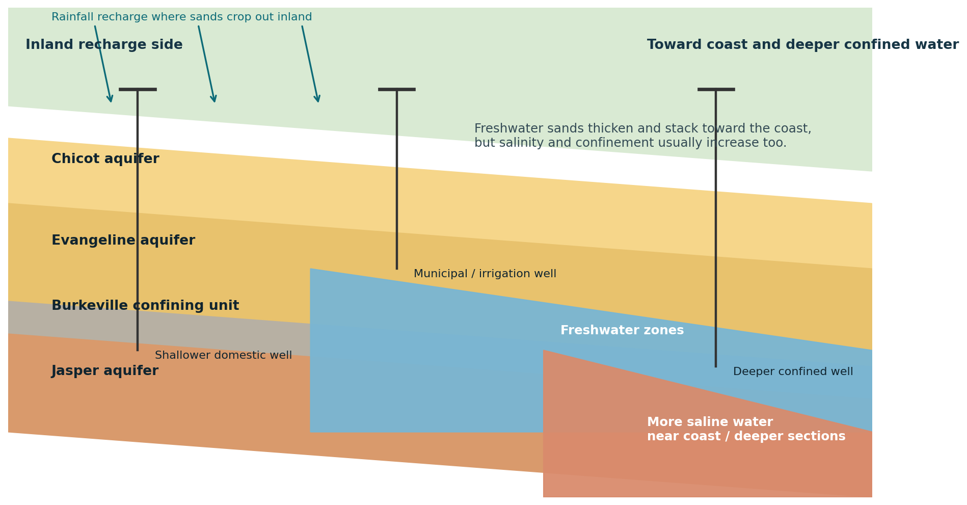
At the broadest level, the system is commonly described through the Chicot, Evangeline, and Jasper aquifers, with the deeper Catahoula carrying water near the outcrop in some areas. The Chicot is the shallowest major component. The Evangeline sits below it, and the Jasper is deeper still, separated in many places by the Burkeville confining system. Local naming changes across the coast, and not every formation is present everywhere, but the private-well lesson stays the same: depth, yield, and water quality depend on which sand package is actually being targeted on your tract.
This system is hydrologically connected and leaky, which means water moves through a large stacked framework rather than a single pressurized chamber. In practical terms, that is why one county can support shallow domestic wells, moderate-depth livestock wells, deeper municipal production, and even saltier or lower-quality water at greater depth. A Gulf Coast address tells you the groundwater family. It does not tell you the specific target interval until you look at the local well record.
Where It Sits in Texas and Why It Matters
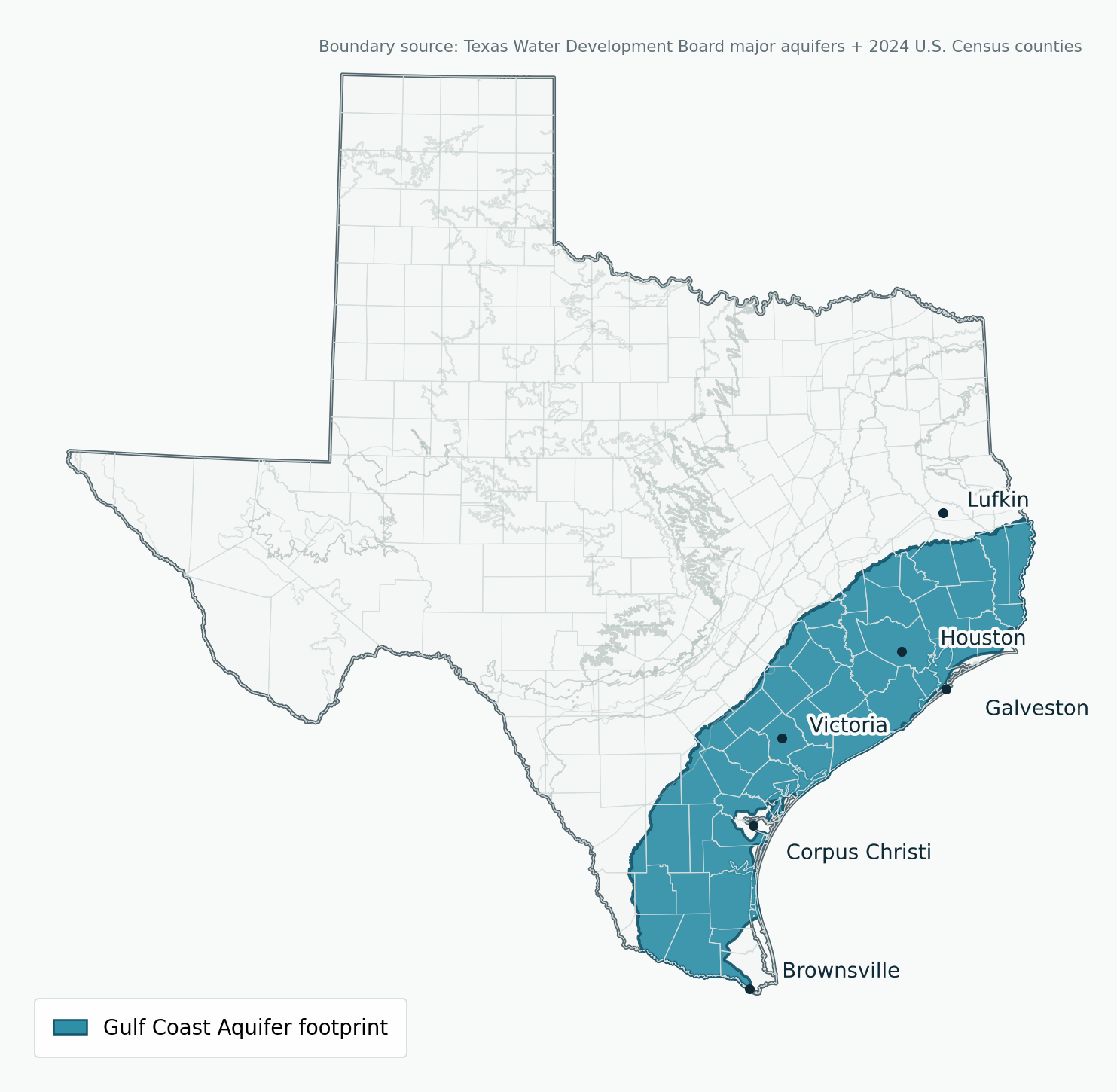
TWDB summary mapping describes the Gulf Coast Aquifer as stretching across all or parts of 54 Texas counties from the Rio Grande northeast to the Louisiana border. That footprint includes the upper coast around Houston and Galveston Bay, the central coast around Wharton, Jackson, Victoria, and Matagorda, the lower coast around Corpus Christi and Cameron County, and East Texas counties like Newton, Jasper, Angelina, Trinity, Polk, and San Augustine that sit in the broader system.
That statewide footprint matters because the Gulf Coast often controls whether rural land is easy or difficult to improve. In some East Texas counties, the system can mean domestic wells with friendlier depth ranges than the deeper sand corridors farther inland. In heavily pumped metropolitan areas, the same aquifer supports large public systems where water levels, subsidence controls, and conversion to surface water have shaped decades of policy. In the coastal south, the same system must also be judged against salinity and chloride risk. No serious land buyer should assume all Gulf Coast wells behave alike.
It also matters for comparison. A county page that sits on the Carrizo-Wilcox Aquifer usually starts with a different sand geometry and often deeper, more targeted drilling logic. A county page that sits on the Trinity Aquifer may involve limestone, sandstone, and a very different DFW-style groundwater story. Gulf Coast private-well planning is its own category, and the farther you get from generic county averages and into local logs, the better your decisions usually get.
The History of the Gulf Coast Aquifer in Texas
The Gulf Coast system has been part of Texas settlement for a long time because shallow groundwater made farming, ranching, towns, and industry possible before large modern surface-water infrastructure reached every area. Early wells were typically shallow and local, but as drilling equipment improved and communities expanded, deeper sand packages in the Gulf Coast system became more valuable. Municipal growth, port development, irrigation, and industrial demand all leaned heavily on this aquifer through the twentieth century.
The Houston story is the clearest example. TWDB history material notes that groundwater from the Chicot and Evangeline aquifers helped support the oil boom, the Houston Ship Channel, and the postwar population surge. Heavy municipal and industrial pumping drove major water-level declines in parts of Harris, Galveston, Fort Bend, and surrounding counties. Over time, those declines compacted dewatered clays and caused measurable land-surface subsidence. In some places around Galveston Bay and greater Houston, the subsidence was not just technical. It translated into flooding exposure, structural damage, and a policy shift toward surface-water conversion and tighter local oversight.
The Gulf Coast also has a strong agricultural history. TWDB summary material says municipal and irrigation uses account for about 90 percent of total pumpage from the aquifer. That helps explain why counties like Wharton, Jackson, Bee, and parts of South Texas can show a very different record than a domestic-well county in the East Texas timber belt. When irrigation-scale withdrawals and public-supply systems dominate a county’s history, the average well depth and the groundwater-management conversation both change.
For today’s property owner, the practical historical lesson is simple. The Gulf Coast system is well studied because it has been worked hard. That is good news if you want data. It is also a warning not to treat old pumpage patterns, old yields, or old urban wells as if they say everything about your tract. The history of the Gulf Coast Aquifer is a history of regional growth, local stress, and increasingly detailed regulation.
What TurnkeyWells Records Show About Gulf Coast Well Depth
The TurnkeyWells groundwater database includes 25,287 GWDB records explicitly tagged to the Gulf Coast Aquifer, and 24,482 of those records include usable depth values. Looking across the full tagged sample, the average recorded depth is about 410.5 feet and the median is about 295 feet. That full-system number is useful for scale, but it is not the number a rural homeowner should use first, because the Gulf Coast sample includes shallow domestic wells, high-capacity irrigation wells, and deep public-supply wells from dense metro corridors.
When you separate the private domestic signal from the rest, the planning picture sharpens. Domestic wells in the Gulf Coast tagged sample have a median depth of about 164 feet. The 25th percentile is about 86 feet, the 75th percentile about 300 feet, and the 90th percentile about 500 feet. That is a much better starting range for a property owner than a full-system average inflated by municipal and industrial drilling.
The system also shows why use type matters. Irrigation wells in the tagged sample have a median depth of about 394 feet and a 90th percentile near 880 feet. Public-supply wells show a median around 555 feet and a 90th percentile near 1,245 feet. If you are planning a single-family house or a small ranch residence, those public-supply numbers are not your budget model. They are context for how extensively the aquifer is used in some counties.
Representative County Planning Table
The table below uses GWDB records explicitly tagged Gulf Coast with usable depth values. It is meant for orientation, not guarantees. The most useful move is still to compare your property against the nearest relevant wells of the same intended use.
| County | Tagged Depth Sample | Average / Median Depth | Dominant Use in Sample | Planning Read |
|---|---|---|---|---|
| Harris | 3,383 records | 687 ft avg / 560 ft median | Public supply | Do not use big-metro depths as a rural home-well default. This is a high-demand municipal and industrial record set. |
| Brazoria | 1,369 records | 391 ft avg / 325 ft median | Public supply | Mixed municipal, rural, and coastal water-quality context. Chloride and coastal management matter more here than in inland timber counties. |
| Montgomery | 1,047 records | 491 ft avg / 341 ft median | Public supply | North-of-Houston growth corridor with deeper public-supply context and active groundwater-management history. |
| Wharton | 1,014 records | 310 ft avg / 255 ft median | Irrigation | Agricultural pumping history shapes the record. Domestic budgeting should still filter for nearby home-scale wells first. |
| Polk | 636 records | 237 ft avg / 200 ft median | Domestic | Closer to the private-well pattern many Southeast Texas acreage buyers actually care about. |
| Bee | 587 records | 235 ft avg / 150 ft median | Domestic | Shallower domestic pattern, but South Texas water quality and irrigation competition can still complicate the picture. |
| Jackson | 511 records | 582 ft avg / 365 ft median | Irrigation | Irrigation history pushes depth higher than many East Texas domestic-well counties. |
| Newton | 257 records | 211 ft avg / 120 ft median | Domestic | A strong example of a Gulf Coast private-well county where the home-scale signal matters more than metro or irrigation averages. |
That spread is the main point. The Gulf Coast label can mean a 120-foot domestic median in one county and a 560-foot public-supply median in another. The aquifer name helps you ask smarter questions. It does not replace parcel-specific due diligence.
How Depth and Yield Change Across the System
The best way to think about Gulf Coast wells is by use, location, and position in the system. East Texas domestic wells often target shallower sands that can work well for a home, livestock setup, or small acreage. Upper-coast metro records are commonly deeper because public-supply systems need more capacity and often target deeper, more protected sands. Central-coast and South Texas counties may show a strong irrigation signature that pulls depth upward compared with a purely residential sample.
Yield data in public records is less consistent than depth data across decades of reporting, so depth and use are the more reliable planning anchors in the TurnkeyWells dataset. Even so, TWDB’s summary material gives a useful scale check: in the Greater Houston metropolitan area, average public-supply well yields have been reported around 1,600 gallons per minute. That is not a private-well benchmark. It simply shows how capable some parts of the system can be when large utilities target the right interval with large-capacity production design.
For a private owner, the better questions are narrower. Are nearby domestic wells clustered under 200 feet or over 350 feet? Are they recent enough to reflect current drilling practice? Are the records mostly domestic wells, or are county averages being distorted by irrigation and public-supply infrastructure? If a county page is dominated by public-supply or irrigation history, you need a tighter filter before you budget a home well.
The system is also coastal and structurally complex. Sands can thicken, pinch, or shift over relatively short distances. Faulting, local depositional changes, and the move from inland recharge-oriented zones toward the coast can all change the target interval. That is why broad system knowledge helps, but the closest usable well logs still matter most.
Water Quality: Where Gulf Coast Wells Get Complicated
Water quality in the Gulf Coast Aquifer is often good in the shallower and fresher parts of the system, especially from the San Antonio River Basin northeast toward Louisiana according to TWDB summary material. But “generally good” is not the same thing as “no testing needed.” The system covers too much ground and too many water chemistries for that kind of shortcut.
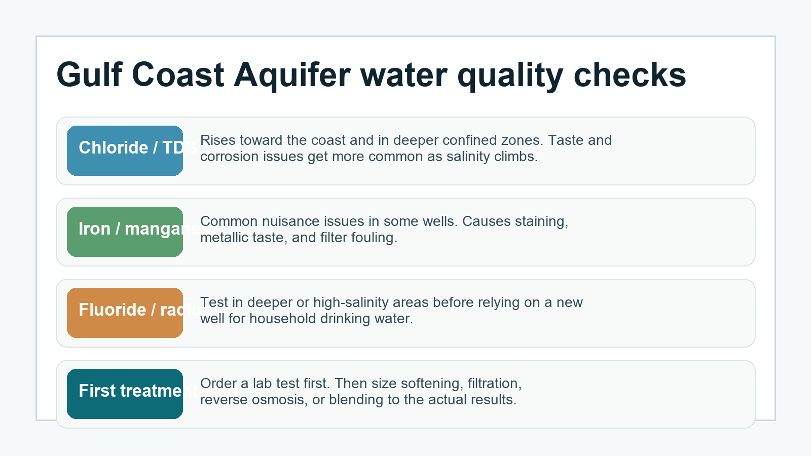
Along parts of the coast and especially farther southwest, the main large-scale risk is salinity. TWDB describes quality deterioration from the San Antonio River Basin southwestward toward Mexico through increased chloride concentration and saltwater encroachment along the coast. In practical terms, that means coastal and South Texas buyers need to be more suspicious of taste, corrosion, and chloride problems than a buyer in an inland East Texas timber tract.
Private-well owners also deal with everyday nuisance issues that may not show up in a one-line aquifer summary. Iron and manganese are common enough in many Gulf Coast settings to justify testing before closing on a home purchase. Fine sand and sediment can show up in shallower wells or in poorly developed completions. In East Texas, tannin color, lower pH, and bacterial risk can matter where surface drainage, old wellheads, or incomplete seals are part of the story. In older coastal infrastructure, corrosion and scaling can both become expensive long before the well is truly out of water.
Testing is the right order of operations. A softener may help hardness or manganese in some cases. Sediment filtration may be part of the answer in sandy completions. Reverse osmosis may make sense for a drinking-water tap when dissolved solids or chloride are elevated. Shock chlorination, continuous disinfection, or ultraviolet treatment can help where a bacterial result requires it. None of those choices should be made blind. The aquifer name gives you a shortlist of probable issues. The lab report tells you what you actually have.
Subsidence, Saltwater, and Other Gulf Coast-Specific Risks
Every major aquifer has its own version of “the thing you ignore at your own expense.” On the Gulf Coast, that thing is not just depth. It is depth plus pumping history plus coastal setting. TWDB summary material notes water-level declines of 200 to 300 feet in parts of eastern and southeastern Harris County and northern Galveston County, with land-surface subsidence reaching as much as nine feet in the most affected areas. That is not a rural-home-well story in every county, but it is the signature Gulf Coast reminder that groundwater history can reshape the surface itself.
Subsidence does not matter only to Houston. It matters because it changed how Texas coastal groundwater is managed. It led to stronger local oversight, shifts toward surface water in some areas, and a different standard of caution around high-volume withdrawals. A buyer planning a home on inland acreage may not be directly constrained by the same issues as a coastal utility, but the regulatory culture in the Gulf Coast region was shaped by those pumping consequences.
Saltwater encroachment is the other system-defining risk. When coastal pumping or natural gradients move poor-quality water landward or upward into freshwater zones, the problem is not easy to reverse at the single-property level. That is why coastal and near-coastal properties deserve a more skeptical review of historic water chemistry, nearby wells, and any signs that a better-quality interval has been bypassed or exhausted.
For a private buyer, these risks translate into three practical moves: compare the property against nearby wells of similar use, test actual water before relying on it, and confirm whether local management bodies treat the area as a subsidence-sensitive or high-demand zone. Those steps cost less than guessing wrong.
Groundwater Districts and Local Oversight
The Gulf Coast Aquifer crosses too many counties for one-size-fits-all regulation. Depending on where the property sits, you may be dealing with a traditional Groundwater Conservation District, a subsidence district, both, or a county where the first practical step is simply confirming who has jurisdiction. In the upper coast, groundwater management has to account for subsidence history and major municipal demand. In agricultural counties, irrigation and production volume can dominate the rulebook. In rural East Texas, the conversation may be simpler, but registration, spacing, and domestic exemptions still need to be checked instead of assumed.
Examples across the broader Gulf Coast region include districts and authorities such as the Harris-Galveston Subsidence District, Fort Bend Subsidence District, Lone Star Groundwater Conservation District, Lower Trinity Groundwater Conservation District, Southeast Texas Groundwater Conservation District, Brazoria County Groundwater Conservation District, and various county-scale coastal and South Texas groundwater districts. The point is not to memorize names. The point is that the applicable rules change by parcel.
Before drilling, deepening, replacing a major well, or buying land that depends on a private well, confirm the governing district through the Free GCD Lookup. Then verify whether the planned use is domestic, livestock, irrigation, public supply, or commercial, because those categories can change permitting, spacing, and reporting obligations. A domestic well may be exempt from part of the permitting process in one jurisdiction while a higher-volume irrigation or commercial well is not.
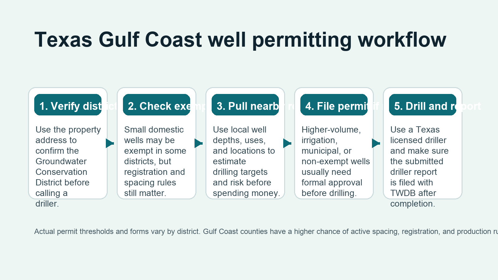
Check the Rules Before You Drill
Coastal and Southeast Texas wells can run into GCD, subsidence-district, spacing, registration, or use-based permit issues. Confirm the district and the nearby well record before you budget the project.
What This Means When Buying Land With an Existing Well
If a property already has a well, the Gulf Coast question is not simply whether the pump turns on. Ask what interval the well targets, how deep it is, how old it is, whether the water has been tested recently, and whether the wellhead protection and surface drainage look competent. A shallow Gulf Coast well can serve a property perfectly well, but it can also be more exposed to bacterial or surface-influence problems if the wellhead is poor and the seal is weak.
Ask for a current test rather than trusting an old report. Ask whether the registered owner on record matches the current ownership chain. Ask whether the property sits in a coastal, subsidence-sensitive, or saltier corridor where long-term water quality matters as much as simple flow. And if the county record is dominated by public supply or irrigation wells, do not let anyone use those big numbers to sell you on a home well without a closer comparable set.
If a seller is completing TREC Form 61-0, the Gulf Coast context matters there too. The seller needs a defensible answer on well presence, groundwater-district jurisdiction, and the basic groundwater picture at the property. The cleaner that record is before closing, the less drama shows up later.
What This Means When Drilling a New Gulf Coast Well
Drilling a new Gulf Coast well starts with restraint. Do not let a county-wide average be your only design input. The right questions are: what do the nearest domestic wells show, what interval are they finishing in, what does the district require, how vulnerable is this tract to shallow-water quality issues, and is there any reason to suspect chloride or saltwater concerns?
For East Texas domestic properties, a realistic planning path often starts with nearby well records, a district check, and a clear decision about intended use. For upper-coast properties around high-growth suburbs, you also need to respect the region’s longer groundwater-management history. For coastal tracts and South Texas properties, you should be thinking about chemistry and salinity sooner than you would in a more inland well market.
The biggest avoidable mistake is treating the Gulf Coast Aquifer as either universally easy or universally risky. It is neither. It is a giant system with plenty of usable domestic-well ground and plenty of places where the wrong assumption gets expensive fast.
Counties in the Gulf Coast System
TWDB mapping places all or parts of 54 Texas counties in the Gulf Coast Aquifer system. That includes major coastal and upper-coast counties like Harris, Brazoria, Fort Bend, Wharton, Jackson, Chambers, Jefferson, Orange, Cameron, Hidalgo, and others, plus East Texas counties such as Polk, Trinity, Angelina, Jasper, Newton, Sabine, and San Augustine.
TurnkeyWells only links county pages here when the page is both live and genuinely relevant to the Gulf Coast story. Two current clean examples are Water Well Drilling in Jasper County, Texas and Water Well Drilling in Newton County, Texas, where the local groundwater record points strongly to a Gulf Coast signal and the domestic-well pattern lines up cleanly with this hub.
Other current East Texas county pages may sit in mixed groundwater country where Yegua-Jackson, Sparta, Carrizo-Wilcox, or Jasper-related signals share the story with the broader Gulf Coast system. That is normal in this part of Texas and exactly why parcel-level well review beats county-name assumptions.
How TurnkeyWells Helps on Gulf Coast Properties
The Gulf Coast Aquifer is a perfect example of why broad public data needs organizing. There is plenty of groundwater information in Texas. The hard part is sorting the right local wells from the wrong comparison set and answering the permitting and water-quality questions in the right order.
The Free Well Check is the fast starting point. It shows nearby registered wells at a Texas address and helps you see whether the local pattern looks shallow, deep, dense, sparse, domestic, or heavily shaped by bigger infrastructure. The Pre-Drill Intelligence Report takes that further by organizing the nearby record set into a property-specific planning view. And the Free GCD Lookup tells you who governs the parcel before you assume anything about exemptions or permits.
Research the Property Before You Commit
On the Gulf Coast, the price of bad assumptions shows up in drilling depth, water chemistry, permit delays, and expensive treatment surprises. Start with the nearby well record and the governing district.
Frequently Asked Questions About Gulf Coast Wells in Texas
How deep is a typical Gulf Coast private well in Texas?
It depends on use and county. In the TurnkeyWells Gulf Coast-tagged sample, domestic wells show a median depth around 164 feet, but many counties run shallower or deeper than that. Public-supply and irrigation records are often much deeper, so home-well planning should focus on nearby domestic wells first.
Is Gulf Coast Aquifer water safe to drink?
Often yes, but not on reputation alone. Water quality is frequently good in fresher parts of the system, yet chloride, iron, manganese, sediment, bacteria, pH issues, and other chemistry problems can still appear. Test the actual well before relying on it for household use.
Why do Gulf Coast records show such different depths?
Because the system covers 54 counties and mixes shallow domestic wells, deep public-supply wells, and irrigation wells across different geologic intervals. A Newton County domestic well and a Harris County public-supply well are both Gulf Coast wells, but they are not the same planning problem.
Do I need a permit to drill a Gulf Coast well?
Sometimes yes, sometimes you may have a domestic exemption, and sometimes you may also be dealing with subsidence-district rules or special reporting. The only reliable answer is parcel-specific, which is why checking the applicable district before drilling matters.
What is the biggest mistake buyers make with Gulf Coast land?
Using the wrong comparison set. Buyers often hear one big county depth number or one old well story and assume it applies to the tract they are evaluating. On the Gulf Coast, nearby wells of the same intended use tell a much better story than broad county averages.
For a shallow river-corridor groundwater comparison, review the Brazos River Alluvium Aquifer Texas property guide.