The Queen City Aquifer in Texas: Property Owner's Guide
East and South Texas groundwater planning
The Queen City Aquifer crosses 42 Texas counties, but the aquifer name alone does not tell you what a particular tract will support. This guide explains the aquifer’s footprint, freshwater and water-quality trends, local well comparisons, district rules, and the checks that matter before buying land or planning a well.
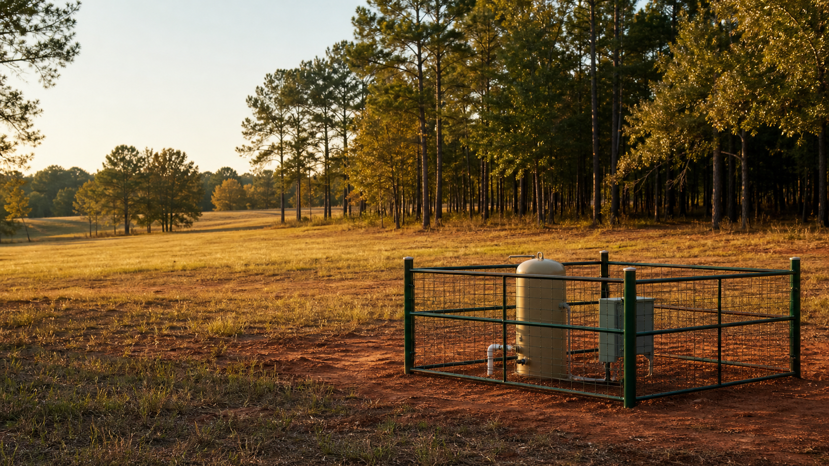
The Queen City is officially a minor aquifer, but its footprint is anything but small. It runs across the upper coastal plain from northeast Texas toward South Texas. The Texas Water Development Board maps 8,781 square miles of outcrop, where the formation reaches the surface, plus 7,015 square miles beneath younger formations.
That wide reach creates a predictable problem for land buyers. A Queen City well in northeast Texas may not have the same depth, chemistry, or regulatory setting as a well carrying the same aquifer label hundreds of miles to the south. County averages can also blend Queen City records with Carrizo-Wilcox, Sparta, Yegua-Jackson, Gulf Coast, or river-alluvium wells. The right question is not simply whether the property sits over the Queen City. It is which nearby wells provide valid comparisons for that exact tract and intended use.
Quick Facts About the Queen City Aquifer
| Planning item | What it means for a property owner |
|---|---|
| Aquifer classification | Texas minor aquifer with both unconfined and confined sections |
| Geographic reach | 42 counties across the Texas upper coastal plain |
| Mapped area | 8,781 square miles of outcrop and 7,015 square miles in the subsurface |
| Water-bearing material | Sand and loosely cemented sandstone separated by clay layers in the Queen City Formation |
| Formation thickness | The formation reaches as much as 2,000 feet thick in South Texas, which is not the same as a typical well depth |
| Average freshwater saturation | About 140 feet, according to TWDB |
| Primary uses | Domestic and livestock use, with significant municipal and industrial use in northeast Texas |
| Groundwater district coverage | About 63 percent of the aquifer lies within groundwater conservation districts |
| Broad water-quality trend | Generally fresh, with average total dissolved solids near 300 mg/L in the recharge zone and about 750 mg/L deeper in the aquifer |
| Northeast Texas warning | Some areas have excessive iron and high acidity |
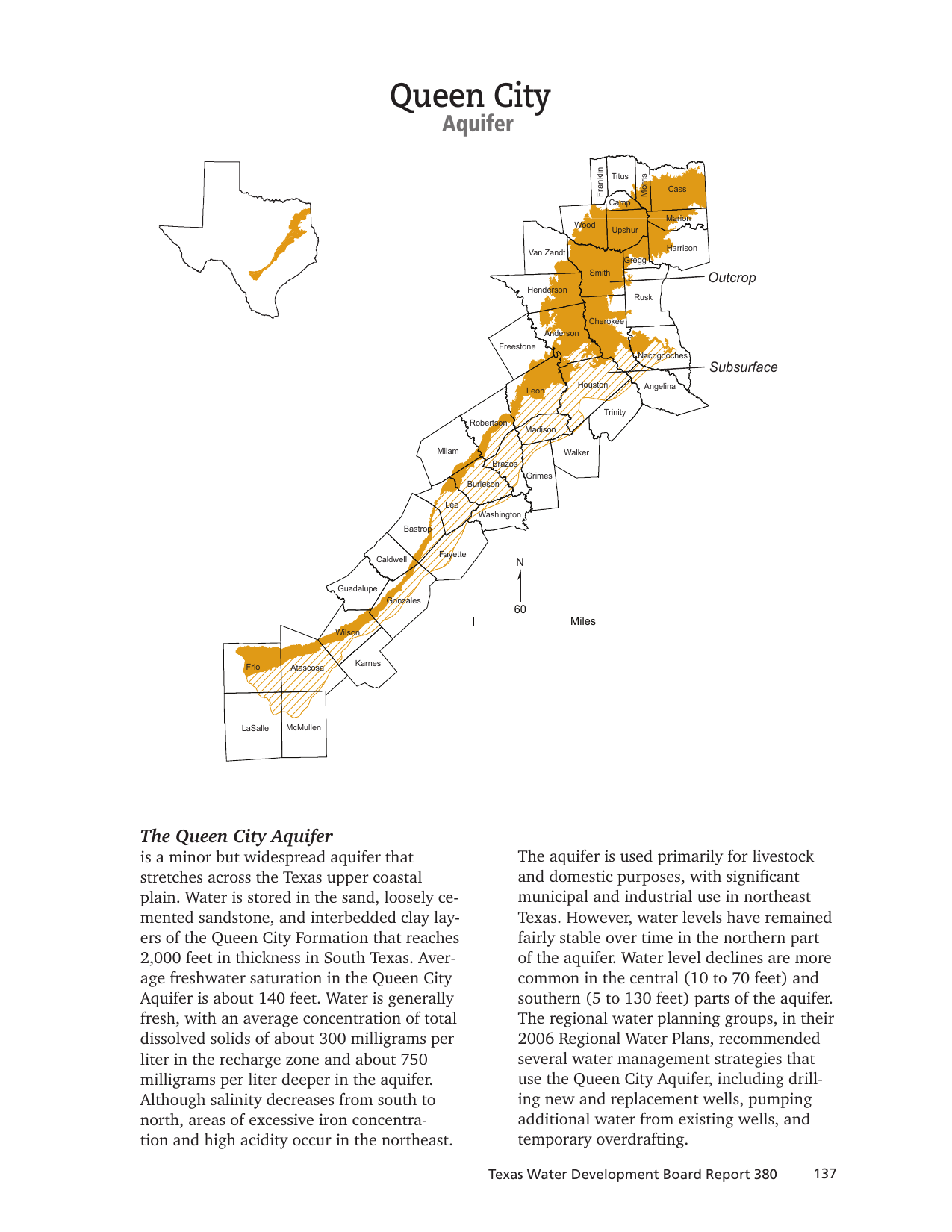
What the Queen City Aquifer Actually Is
The Queen City stores groundwater in sand and loosely cemented sandstone within the Queen City Formation. Clay layers occur between those water-bearing beds. Where the formation is exposed at the surface, the aquifer is unconfined and rainfall can enter the system more directly. Farther downdip, younger formations cover the Queen City and help confine the water under pressure.
Confined does not automatically mean a well will flow at the surface. It means the water is under pressure and may rise in the casing above the top of the producing interval. The actual water level, finished depth, available drawdown, and pump design still depend on the property and local completion history.
TWDB reports that the Queen City Formation reaches up to 2,000 feet thick in South Texas, while average freshwater saturation across the aquifer is about 140 feet. Those numbers describe regional geology. They should not be turned into a drilling quote or assumed well depth. A well only needs to be designed around the productive interval and conditions at the tract, not the formation’s maximum regional thickness.
Outcrop and Confined Areas Create Different Planning Problems
On the outcrop, the Queen City is closer to the surface and more directly connected to recharge. That can support shallower local completions, but it can also make water quality more sensitive to land use, septic systems, livestock activity, and surface conditions. A shallow well should never receive a clean bill of health based only on appearance or taste.
In confined areas, the target interval may be deeper and separated from the surface by lower-permeability layers. That can reduce some direct surface influence, but it raises different questions about drilling depth, pressure, mineral content, and whether nearby municipal or industrial records are appropriate household comparisons.
The most useful comparison set usually comes from nearby wells completed for the same purpose. A domestic buyer needs domestic records first. A livestock or irrigation project should study wells serving a similar demand. A municipal well may prove that the formation can produce water at scale, but its depth, construction, pumping test, and budget may have little value for a single home.
How the Queen City Changes Across Texas
The Queen City runs through a layered coastal-plain groundwater setting. In many counties, records may carry Queen City, Carrizo-Wilcox, Sparta, Yegua-Jackson, mixed, or unassigned labels. Some wells cross more than one named interval. Older records may use broad aquifer labels that do not match newer mapping cleanly.
Northeast Texas has the aquifer’s most significant municipal and industrial use. It is also where TWDB flags excessive iron and high acidity in some areas. Farther south, TWDB says salinity generally increases. That broad trend is useful for deciding which laboratory parameters deserve attention, but it does not predict the chemistry from a particular well.
Cass County shows why the comparison set matters. The county groundwater file includes Queen City records as well as a large Carrizo-Wilcox and Queen City combination group. The live Cass County water well guide provides local context, but even that county-level page cannot replace nearby records around an exact parcel.
Well Depth and Yield Require Local Evidence
TWDB’s Queen City summary does not publish one statewide household well-depth or yield range, and that is appropriate for an aquifer spanning 42 counties. A single number would hide changes in elevation, outcrop position, formation dip, local sand thickness, pumping demand, and the aquifer interval selected by the driller.
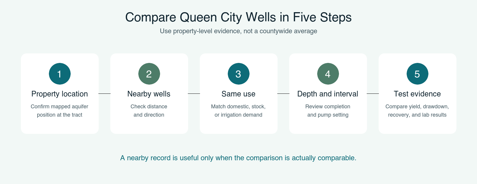
Before treating a nearby well as a comparable, check at least five things:
- Distance and direction from the property
- Total depth, completed interval, casing, screen, and pump setting
- Intended use, such as domestic, livestock, irrigation, public supply, or industrial
- Completion date and whether the record reflects current pumping conditions
- Reported yield, test duration, drawdown, and recovery when those fields exist
A driller’s reported gallons per minute at completion is not a guarantee of long-term household supply. Test length, drawdown, recovery, drought, nearby pumping, pump design, and storage all affect what the owner can use reliably. The Free Well Check is the sensible first pass because it helps identify nearby registered wells before a project is priced from a countywide average.
Queen City Water Quality: Fresh Does Not Mean Untested
TWDB describes Queen City groundwater as generally fresh. Average total dissolved solids are about 300 milligrams per liter in the recharge zone and about 750 milligrams per liter deeper in the aquifer. Salinity decreases from south to north, but that regional pattern does not guarantee drinking-water quality from an individual well.
In northeast Texas, excessive iron can cause orange or brown staining, metallic taste, sediment, and treatment-system fouling. High acidity means low pH may also be a concern in some areas. Acidic water can contribute to corrosion in plumbing and equipment, especially when the system contains vulnerable metals.
For a domestic well, a practical laboratory panel should include total coliform and E. coli bacteria, nitrate, pH, iron, manganese, hardness, chloride, sulfate, and total dissolved solids. Property conditions may justify additional testing for arsenic, lead, petroleum compounds, pesticides, or other contaminants. A state aquifer summary cannot replace a certified laboratory result from the actual well.
Buying Property With an Existing Queen City Well
An existing well can be valuable, but only when its condition and record are understood. Ask for the driller report, pump information, repair history, recent lab results, and any groundwater district registration or permit. Confirm that the well being discussed is actually on the property and that the reported aquifer and depth fit the available public record.
Run the well under realistic demand and have qualified professionals evaluate pressure, flow, water level, recovery, electrical controls, storage, and treatment equipment. A brief faucet test tells you almost nothing about sustained capacity. Likewise, clear water in a glass does not answer the bacteria, acidity, iron, or dissolved-mineral questions.
For a Texas sale involving groundwater, documentation also matters to the transaction file. The TREC Form 61-0 water disclosure guide explains the current disclosure workflow. Buyers, sellers, agents, and title professionals should reconcile the seller’s statements with available records rather than waiting until closing to discover that a well’s identity or district status is uncertain.
Planning a New Queen City Well
Start with the tract, not the aquifer headline. Confirm the mapped aquifer position, review nearby comparable wells, identify the groundwater district, and then ask licensed drillers how they interpret the local record. A useful proposal should explain the likely target interval and major uncertainties without pretending the subsurface is guaranteed.
Do not budget from formation thickness or from the deepest well in the county. Do not assume a nearby public-supply completion is the right design for a house. Do not assume that fresh regional water eliminates treatment. The defensible plan combines nearby domestic evidence, current district rules, site access, septic and setback constraints, expected water demand, and a post-completion laboratory test.
Check the Property Before You Trust the Aquifer Label
A Queen City map confirms regional context. Nearby comparable wells and the actual district rules turn that context into a usable property decision.
Groundwater District and Permit Checks
TWDB reports that about 63 percent of the Queen City Aquifer lies within groundwater conservation districts. That percentage is a regional fact, not a yes-or-no answer for a property. District boundaries can cut across counties, and local rules can differ on registration, permits, spacing, production, reporting, and domestic or livestock exemptions.
Use the Free GCD Lookup on the property address, then verify the result with the district before drilling or changing well use. A domestic exemption, when available, does not necessarily erase registration, spacing, construction, or reporting obligations. The district and a licensed Texas water well driller should confirm the current requirements.
How the Queen City Compares With Nearby Aquifers
The Queen City sits between other important coastal-plain aquifer units. It should not be treated as another name for the Carrizo-Wilcox Aquifer, even though county records and older descriptions sometimes group them. The formations occupy different stratigraphic positions and may produce different depth and water-quality outcomes on the same regional trend.
The Sparta Aquifer and Yegua-Jackson Aquifer also appear in many of the same East and Central Texas county conversations. Along river valleys, shallow alluvial wells can create another comparison problem. A county total that blends all of those systems is useful for inventory, but weak for pricing or judging a Queen City household well.
Related Queen City Property Resources
- Cass County private well and aquifer planning
- Carrizo-Wilcox Aquifer guide for Texas property owners
- Sparta Aquifer property owner’s guide
- Yegua-Jackson Aquifer property owner’s guide
Frequently Asked Questions About the Queen City Aquifer
Is the Queen City a major aquifer?
No. Texas classifies it as a minor aquifer, but it is widespread and crosses 42 counties. Minor describes its statewide classification, not whether it matters to a particular property.
How deep is a Queen City well?
There is no responsible statewide answer. Depth changes with outcrop or downdip position, elevation, local sand development, target interval, and intended use. Compare nearby wells serving the same purpose and have a licensed driller interpret the tract.
Is Queen City groundwater fresh?
TWDB says it is generally fresh. Average total dissolved solids are about 300 mg/L in the recharge zone and about 750 mg/L deeper in the aquifer. Individual wells still require laboratory testing.
What water-quality problems occur in the Queen City?
TWDB identifies excessive iron and high acidity in parts of northeast Texas. Salinity is generally greater toward the south. Bacteria and nitrate are property and well-condition questions that also belong in domestic testing.
Do I need a permit for a Queen City well?
Requirements depend on the property’s groundwater district and the proposed use. About 63 percent of the aquifer has groundwater district coverage. Check the exact address and confirm current rules before drilling.
What should I verify before buying land with a Queen City well?
Verify the well location, driller report, depth and construction, pump and repair history, sustained performance, laboratory results, district status, and disclosure record. Then compare the well with nearby records that match its intended use.
Build the Decision Around the Property
Use the aquifer map for context, then check nearby wells, district jurisdiction, and water-quality risk before you buy or drill.
Sources: Texas Water Development Board, Queen City Aquifer summary, and TWDB Report 380, Aquifers of Texas. Aquifer boundaries, well depth, yield, water quality, and groundwater district requirements vary by property. This guide is for planning and education. It is not a drilling guarantee, laboratory certification, engineering opinion, legal opinion, or permit determination.