East and Central Texas coastal-plain groundwater planning
A practical guide to Sparta well depth, mixed county signals, water-quality watchouts, district rules, and what Texas property owners should verify before buying or drilling on a layered sand-and-clay tract.
The Sparta Aquifer is less forgiving than its "minor aquifer" label sounds. The file is full of counties where a rural household well, a public-supply well, and an abandoned deeper test hole can all carry the same aquifer name while pointing to three very different budgets. Buyers get burned when the impressive deep number wins the conversation before anyone sorts intended use, county position, or chemistry risk.
That is what separates Sparta from the broader Yegua-Jackson and Gulf Coast conversations. Sparta is a narrower inland sand corridor with a sharper split between East Texas household patterns and the deeper Brazos, Burleson, and Fayette side of the file. A tract in Houston or San Augustine County can behave like a practical domestic-well decision. A tract farther west can shift quickly into a deeper-treatment and full-system planning problem.
This guide is built for that split. It uses current Texas Water Development Board mapping and the TurnKeyWells record to sort Sparta into a household lane, a mixed-county warning lane, and a deep-use caution lane so a buyer can decide whether the next move is a quick Well Check, a fuller Pre-Drill file, or a hard stop until the groundwater story is cleaner.
Quick Facts About the Sparta Aquifer in Texas
| Planning item | Practical property-owner meaning |
|---|---|
| Aquifer type | minor Gulf Coastal Plain aquifer made of Sparta sands with clay-rich confining intervals and lignitic coastal-plain material. It is a layered groundwater corridor, not a single clean sandstone body that behaves the same everywhere. |
| Texas extent | About 6,321 square miles in the current TWDB minor-aquifer mapping. It covers a long East and Central Texas belt where county averages are often less useful than nearby domestic well records. |
| Aquifer-tagged records | 1,012 GWDB wells tagged exactly Sparta, with 952 usable depth values. |
| Overall depth range | Median about 308 feet, with the middle half running from about 140 to 500 feet and the 90th percentile near 759 feet. |
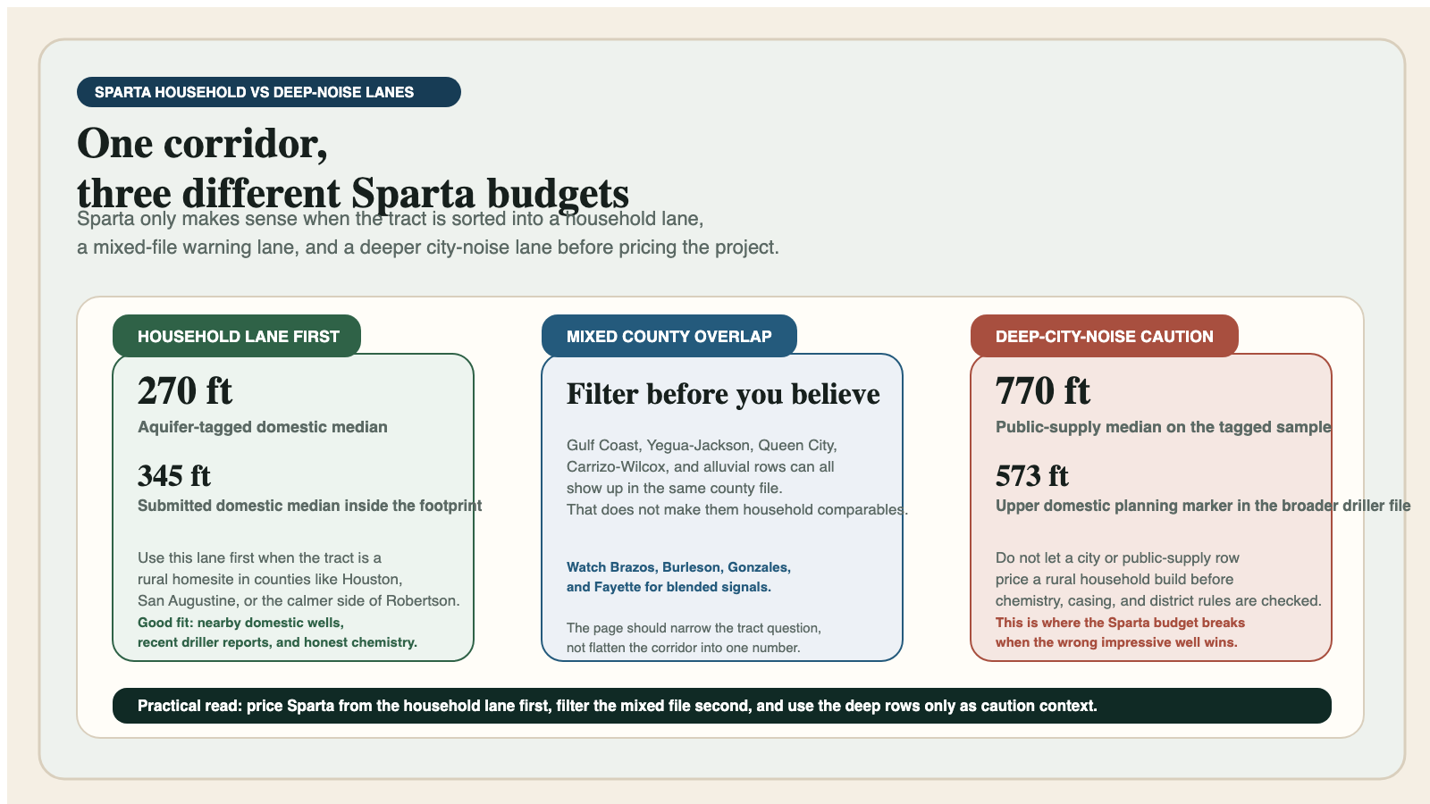
| Domestic-well depth range | 392 aquifer-tagged domestic rows with a 270-foot median and a middle band of about 138 to 425 feet. |
| Stock-well depth range | 133 stock rows with a 327-foot median. That keeps the aquifer grounded in ranch and acreage use, not just city supply. |
| Public-supply depth range | 50 public-supply rows with a 770-foot median and a much wider upper-end tail than most household projects should use as a default budget. |
| Submitted driller-report domestic signal inside the mapped footprint | 7,587 domestic rows with a 345-foot median total depth and a 573-foot upper planning marker. |
| Main planning risk | Mixed county groundwater stories. Sparta often overlaps counties where Gulf Coast, Yegua-Jackson, Queen City, Carrizo-Wilcox, or alluvial signals also show up and can distort the wrong comparison set. |
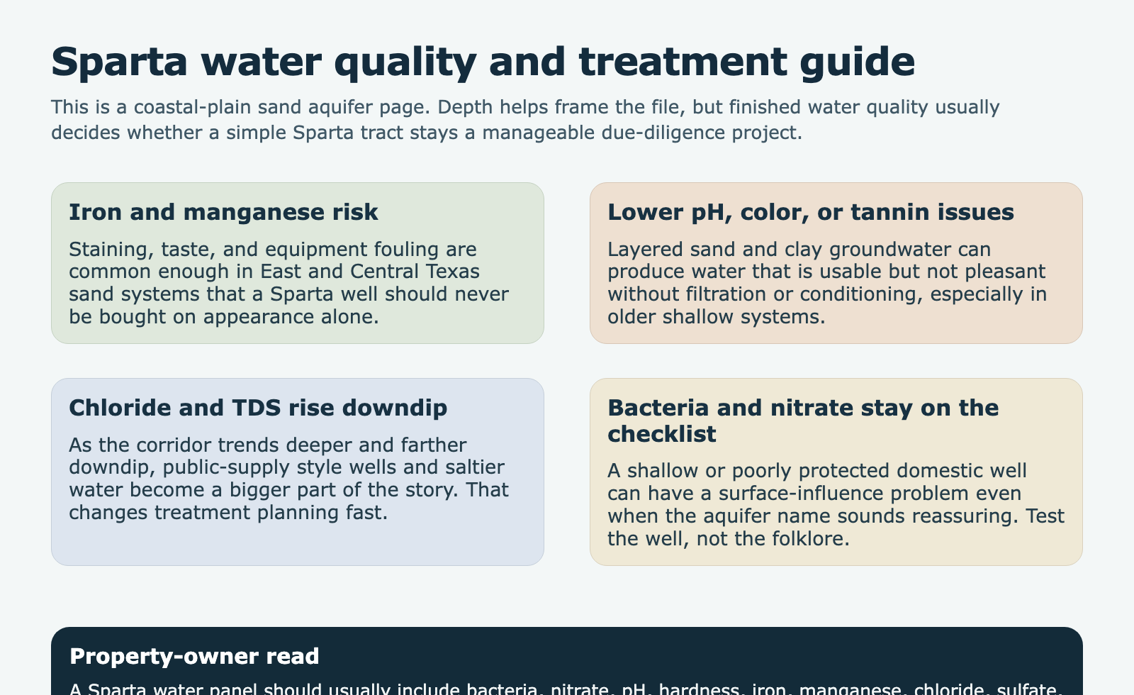
| Main water-quality watchouts | Iron, manganese, color, lower pH, and rising dissolved-solids or chloride risk in deeper or downdip lanes. Test the actual well before trusting the aquifer reputation. |
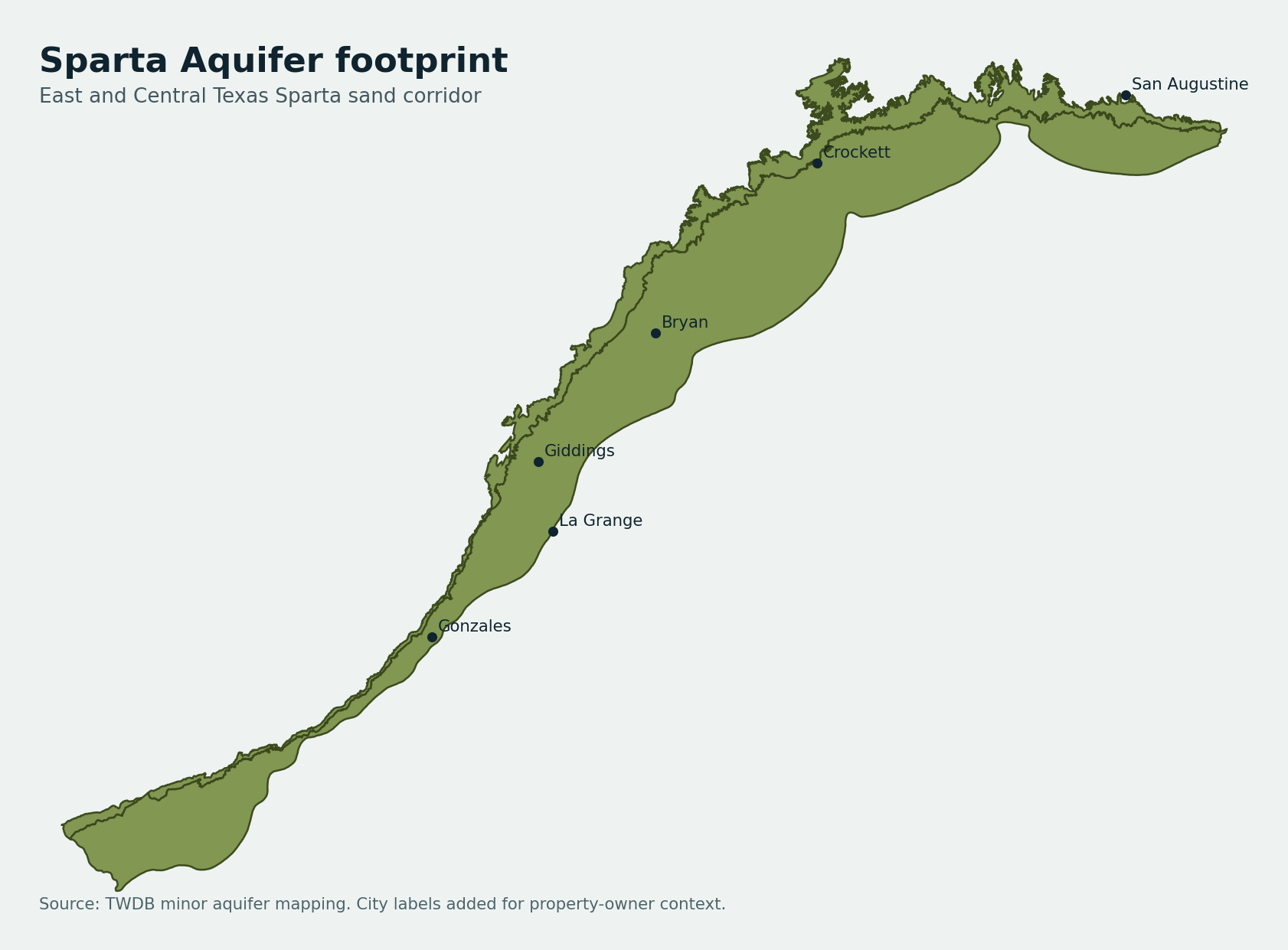
What the Sparta Aquifer Actually Is
The Sparta is not a giant catch-all coastal-plain label. In Texas it is a thinner sand-and-clay corridor that keeps asking the same question: are you looking at a household well, or are you staring at a deeper city, industrial, or public-use record that should never set a household budget?
Geologically, Sparta sands can absolutely support useful domestic wells, but the tract story changes faster than buyers expect as the corridor moves from East Texas timber-country counties into the Brazos, Burleson, and Fayette side of the map. That is why this page needs county position, intended use, and nearby domestic completions together rather than a statewide slogan about "Sparta depth."
The practical read is simple. Sparta is a sorting aquifer. If the nearby record is clean and domestic-heavy, the file can be encouraging. If the same county file is crowded by deeper public-use or mixed-label rows, the first job is filtering, not optimism.
Why Buyers Get Burned by Mixed County Signals
The most common Sparta failure is using the most dramatic well in the dataset instead of the most relevant one. A deep public-supply or municipal-adjacent well looks authoritative on paper, so it gets quoted first. Then a household buyer builds a budget around a number that belonged to a completely different project.
Sparta also creates false confidence in the other direction. A shallow domestic example from the calmer side of a county can make a deeper tract look easier than it is. In this corridor the wrong "lucky" comparable is just as dangerous as the wrong scary one.
That is why mixed-county discipline counts for more here than broad aquifer folklore. Houston, San Augustine, Brazos, Burleson, Fayette, Gonzales, and Robertson do not represent one reusable drilling story. They represent planning lanes that need to be separated before money moves.
What the TurnkeyWells Record Shows About Sparta Depth
The raw Sparta numbers already warn against shortcuts. The tagged sample centers at about 308 feet, but the middle band is wide and the upper end reaches far past what most rural buyers expect when they first hear "minor aquifer." That spread alone is enough to make one-number budgeting unreliable.
The household lane is still real. Domestic rows center around 270 feet, which is why Sparta should not be treated like a hopeless deep-water page. But stock, irrigation, and especially public-supply rows pull the file in different directions fast, and that is where a tract budget drifts if use is not sorted first.
The broader driller-report footprint reinforces the same warning. A 345-foot domestic median and a 573-foot upper planning marker are not contradictory. They are the corridor telling you to separate the normal household pattern from the harder tail before you commit to a build.
Record Snapshot
The Sparta Aquifer is a sorting aquifer. Most expensive mistakes happen when a household project borrows a deep-use number it never should have copied.
County Sparta Planning Lanes
The county table is useful only if it keeps the lanes separate. Read it as a map of where Sparta stays calmer for household planning, where it starts to deepen, and where mixed labels or deeper-use rows demand more caution.
| County | Record density | Depth signal | Main use in exact sample | How to read it |
|---|---|---|---|---|
| Houston County | 107 aquifer-tagged depth rows | 371 ft avg / 330 ft median | Domestic | A high-density Sparta county where domestic evidence is strong enough to guide buyers, but the file still gets distorted if deeper public-use rows are treated like kitchen-and-bath comparables. |
| Brazos County | 103 aquifer-tagged depth rows | 532 ft avg / 500 ft median | Domestic | One of the clearest mixed-county examples. Sparta is real here, but deeper municipal and public-supply noise can push a household budget badly off course. |
| Burleson County | 103 aquifer-tagged depth rows | 553 ft avg / 420 ft median | Domestic | A useful transition county where domestic, stock, unused, and public-supply Sparta rows all show up together. That makes use sorting non-negotiable. |
| San Augustine County | 34 aquifer-tagged depth rows | 215 ft avg / 187 ft median | Domestic | A cleaner East Texas domestic read that helps anchor the page on private-well reality instead of only on deeper corridor numbers. |
| Bastrop County | 31 aquifer-tagged depth rows | 264 ft avg / 250 ft median | Domestic | Shows the west-central edge of the Sparta story, where the aquifer can still be relevant on acreage but should not be treated like a uniform one-depth answer. |
| Fayette County | 31 aquifer-tagged depth rows | 465 ft avg / 464 ft median | Domestic | A deeper central-corridor Sparta sample that keeps the page honest about how quickly the planning burden can change from one county to the next. |
| Gonzales County | 58 aquifer-tagged depth rows | 427 ft avg / 470 ft median | Domestic | A south-central transition county where Sparta sits inside a broader mixed-groundwater conversation and buyers need nearby domestic wells more than folklore. |
| Robertson County | 20 aquifer-tagged depth rows | 172 ft avg / 170 ft median | Domestic | Helpful because the depth signal looks calmer than Brazos or Burleson, which proves the aquifer does not behave like one corridor-wide drilling number. |
Houston and San Augustine ground the page in real East Texas domestic evidence. Brazos, Burleson, and Fayette show where deeper or noisier files can pull a buyer off course. Gonzales and Robertson prove the corridor does not move in one direction at one speed.
Water Quality: Where the Sparta Turns Into a Real Ownership Question
Sparta water quality can be more expensive than the drill-depth mistake. A tract can hit a usable sand and still produce water that needs treatment for iron, manganese, color, low pH, or a stronger dissolved-solids load than the buyer expected.
That is why Sparta should be read as a full-system page, not a footage page. A cheaper depth number can still turn into a worse ownership outcome if the water requires storage, filtration, oxidation, softening, or more maintenance than the seller ever disclosed.
The risk usually grows as the file trends deeper or farther downdip, which is one reason the public-supply side of the Sparta sample looks so different from the household side. Those deeper rows are useful as caution context, but they are not permission to guess treatment cost after closing.
If the tract already has a well, order a fresh lab panel and treat the result as part of the acquisition file. If the tract needs a new well, keep chemistry on the same planning checklist as depth, casing, storage, pump sizing, and district rules.
Groundwater Districts and Local Oversight
Sparta also crosses enough county and district boundaries that the rulebook can change before the water story does. A buyer who gets the well comparison right can still lose time or money by assuming the county name alone answers the permitting question.
That is why the first live check is still the GCD lookup. Domestic and livestock use may be simpler, but spacing, registration, production, or higher-volume uses can shift the timeline and paperwork faster than a county-average depth table will reveal.
On Sparta tracts, the clean workflow is: confirm the district, isolate the right domestic comparables, review chemistry or treatment risk, then price the complete ownership problem. The wrong order creates false confidence.
Buying Property With an Existing Sparta Well
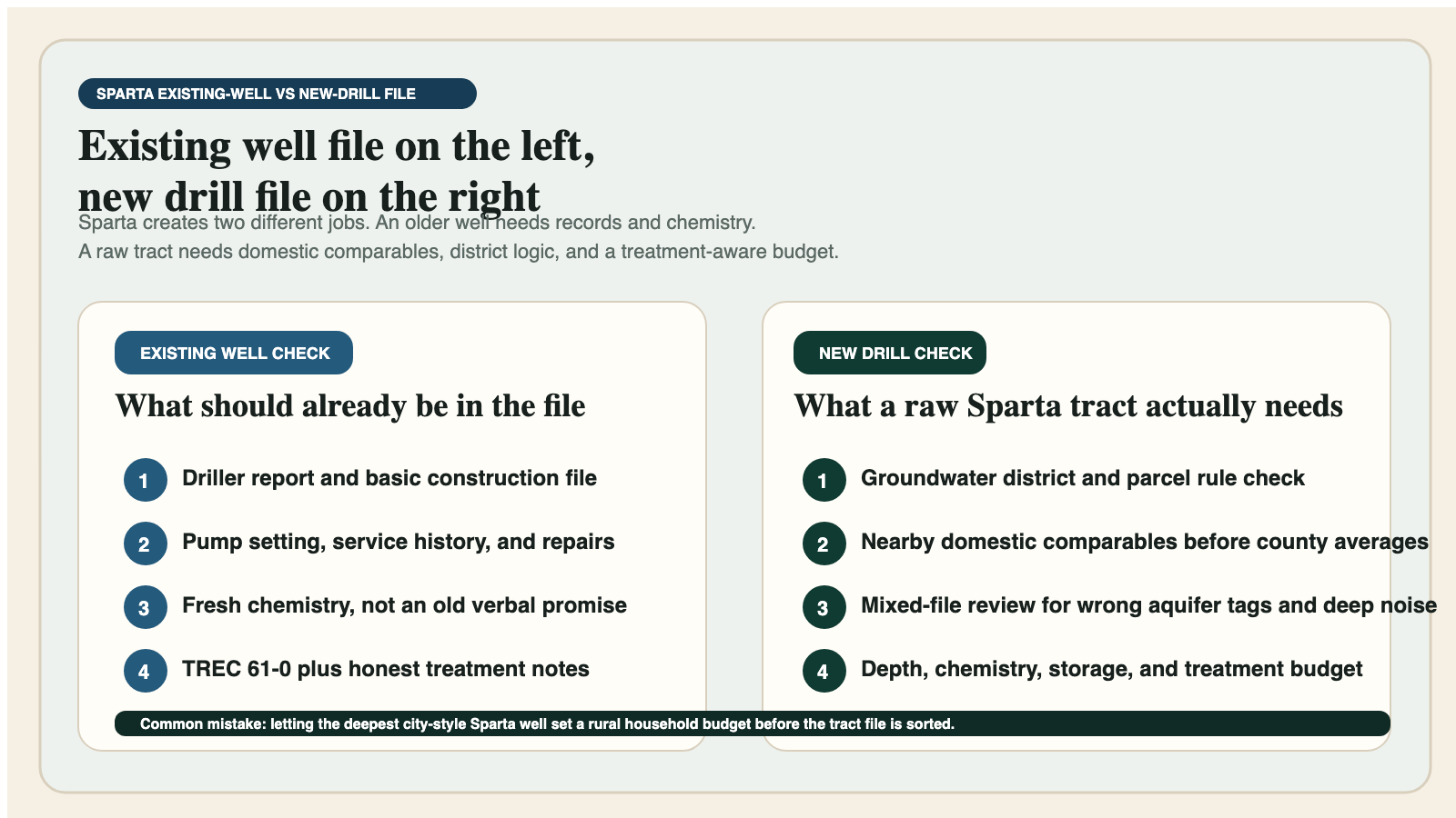
If a Sparta tract already has a well, ask whether the file is clean enough to survive closing. The driller report, pump setting, service notes, treatment equipment, and fresh chemistry panel all belong in the conversation before anyone celebrates that the faucet works.
That discipline becomes even more important when the deal involves TREC Form 61-0. Sparta buyers and sellers both benefit when the groundwater story is documented instead of narrated from memory, because the expensive surprises on this page usually come from missing records or stale water-quality assumptions.
Planning a New Sparta Well
A new Sparta well should be priced from nearby domestic evidence first. Start with the household lane, not the deepest public-supply row and not the one lucky shallow well somebody remembers from a better tract.
The good news is that Sparta does show a real domestic pattern. The danger is that the pattern sits beside a much deeper caution lane. That split is why the page is useful: it can tell you whether the tract still looks like a normal rural domestic project or whether it needs a fuller pre-drill file before anyone quotes a budget.
When the property is real enough to spend money on, the Pre-Drill Intelligence Report is the right escalation because it forces the comparison set, district logic, and chemistry-treatment planning into one file instead of letting each answer show up too late.
Relevant Live County Pages in the Sparta Corridor
Useful county examples in the Sparta corridor include Houston County, Brazos County, Burleson County, San Augustine County, Bastrop County, Fayette County, Gonzales County, and Robertson County. Those pages help because they show how the corridor changes from one county to the next instead of pretending the aquifer is uniform.
Just as important are the counties this page does not force. Some Sparta counties also sit in stronger Gulf Coast, Yegua-Jackson, Carrizo-Wilcox, or alluvial narratives. A county only belongs here when the aquifer relationship is real enough to help a property owner rather than just pad the interlink count. Accuracy beats filler on aquifer pages.
How the Sparta Aquifer Compares With Other TurnkeyWells Aquifer Guides
Sparta overlaps other TurnKeyWells aquifer guides, but it should not be blurred into them. Gulf Coast work often leans harder into Chicot, Evangeline, Jasper, and broader coastal salinity stories. Yegua-Jackson usually reads like a wider multi-county corridor with a larger mid-depth household lane. Sparta is narrower and more likely to punish a buyer who confuses domestic evidence with deep municipal noise.
It also behaves differently from the Carrizo-Wilcox Aquifer, where a different regional sand story and a different set of budget expectations dominate the file. Sparta’s personality is mixed counties, usable household evidence, and a constant need to filter out the wrong impressive well.
How TurnkeyWells Helps on a Sparta Property
TurnKeyWells helps by sorting the record before the budget hardens. A Free Well Check gives the first pass on nearby registered wells, record density, and whether the tract sits in a cleaner household lane or a mixed-file lane that needs more discipline.
When the property is real, the Pre-Drill Intelligence Report and GCD lookup turn that first pass into a tract file: nearby domestic comparables, district context, treatment watchouts, and the deeper caution lane that should inform the budget without hijacking it.
Frequently Asked Questions About Sparta Wells in Texas
How deep is a typical Sparta private well in Texas?
There is no single statewide Sparta number, but the household lane in the tagged sample centers around 270 feet and the broader domestic driller file centers around 345 feet. Some tracts will come in easier than that, and some will run much deeper once the mixed-file or downdip cautions show up.
Is Sparta water good?
Sometimes yes, but Sparta water should be judged by the actual sample, not the aquifer nickname. Iron, manganese, color, low pH, and in deeper lanes stronger dissolved-solids or chloride pressure can all change the treatment cost.
Why do some Sparta counties look much deeper than others?
Because Sparta crosses mixed counties, different use types, and different positions in the coastal-plain sequence. A San Augustine household well and a deeper Brazos or Burleson public-use row can both be Sparta without belonging in the same household budget conversation.
What is the easiest mistake to make on a Sparta property?
Using the wrong comparable wells. Sparta buyers get in trouble when a deep city-style or mixed-file row is treated like a kitchen-and-bath household comparable. Sorting the local domestic evidence is usually the difference between a sound plan and an expensive one.
The Bottom Line on the Sparta Aquifer in Texas
The Sparta Aquifer is not an aquifer that rewards shortcuts. It is a useful, real-world groundwater corridor for Texas property owners, but only when it is read as a layered, mixed-county, use-specific planning problem. The safe play is simple: verify the district, sort the nearby domestic wells, test the actual water, and budget the full system instead of just the drill hole. That is competent due diligence, not overkill.
That is exactly where TurnkeyWells helps. Start with the Well Check, confirm the district, and use the Pre-Drill report before you trust the wrong county average or the wrong impressive well nearby. On a Sparta tract, that discipline is what keeps an ordinary rural property decision from turning into a correction project.
For another East Texas groundwater comparison, review the Queen City Aquifer Texas property guide.