The Brazos River Alluvium Aquifer in Texas: Property Owner's Guide
Brazos River groundwater planning
The Brazos River Alluvium Aquifer follows 350 river miles through 13 Texas counties. Its shallow, unconfined sand and gravel can support productive wells, but the aquifer changes quickly across a floodplain. This guide explains the geology, river connection, yield evidence, hard-water risk, and property checks that matter before you buy land or plan a well.
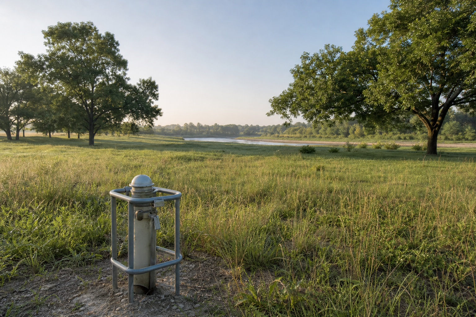
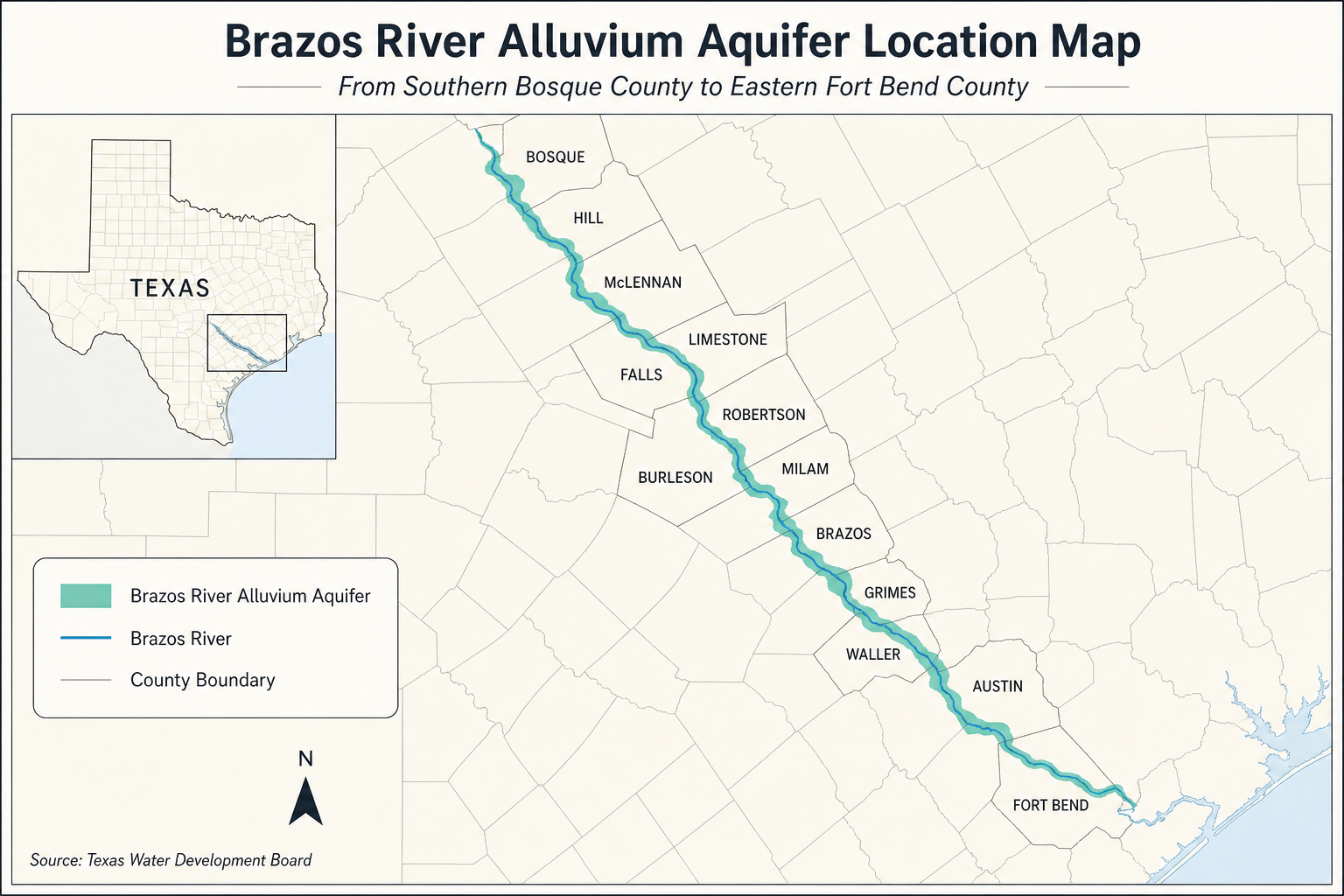
The Brazos River Alluvium is not a broad regional formation that sits uniformly under whole counties. It is a ribbon of river-deposited material extending from southern Bosque County to eastern Fort Bend County. The Texas Water Development Board maps 1,057 square miles of aquifer, as much as seven miles wide in places.
That narrow geometry is the first property lesson. A tract can be in a county crossed by the aquifer without sitting on productive Brazos alluvium. Even inside the mapped footprint, sand and gravel lenses can pinch out or grade into silt and clay. An aquifer map establishes context. It does not prove that a particular homesite has a productive interval.
Quick Facts About the Brazos River Alluvium Aquifer
| Planning item | What it means for a property owner |
|---|---|
| Aquifer classification | Texas minor aquifer, unconfined and under water-table conditions in most places |
| Geographic reach | About 350 river miles from southern Bosque County to eastern Fort Bend County |
| County footprint | Parts of 13 counties, not every tract in those counties |
| Mapped area | 1,057 square miles and as much as seven miles wide |
| Water-bearing material | Floodplain sand and gravel mixed with silt and clay |
| Thickness | Negligible to 168 feet, averaging about 50 feet regionally |
| Reported yields | Most wells yield 250 to 500 gallons per minute; some reach 1,000 gpm, primarily relevant to irrigation-scale use |
| Main use | Irrigation |
| Water quality | Very hard and fresh to slightly saline; generally below 1,000 mg/L TDS but as high as 3,000 mg/L in some wells |
| District coverage | About 85 percent lies within groundwater conservation districts |
What the Brazos River Alluvium Aquifer Actually Is
Alluvium is material deposited by flowing water. Along the Brazos, the productive floodplain deposits include fine to coarse sand and gravel, with silt and clay mixed through the sequence. TWDB says terrace deposits also occur but are not an appreciable groundwater source. For property planning, a terrace label and a floodplain-alluvium target should not be treated as interchangeable.
The deposits have complex geometry. Beds and lenses of sand and gravel can end abruptly or transition vertically into finer material. In general, finer sediment occurs higher in the aquifer and coarser material occurs lower. That pattern helps explain why a nearby irrigation well can be encouraging without guaranteeing the same completion a short distance away.
TWDB reports thickness from negligible to 168 feet, with an overall average near 50 feet. Those are aquifer-thickness figures, not promised well depths. Ground elevation, saturated thickness, river position, local sediment, and the selected completion interval all affect the finished well.
The Brazos River Connection Changes the Due Diligence
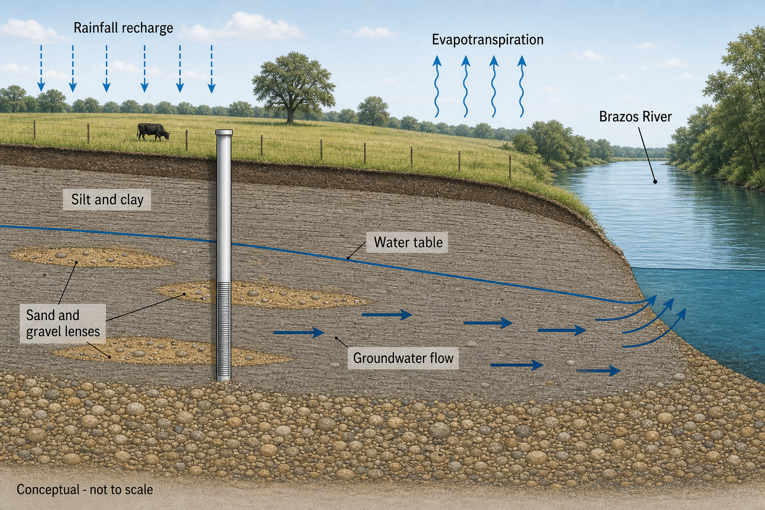
The water table generally slopes toward the Brazos River. TWDB interprets that direction as evidence that the river is a gaining stream in most places, meaning groundwater commonly discharges toward the river. Recharge comes from rainfall on the aquifer followed by downward leakage into the saturated zone. Discharge occurs through evapotranspiration, flow to the river, and pumping.
This connection does not mean a landowner can assume a well has a fixed river-supplied yield. River stage, drought, local pumping, sediment continuity, and the well’s distance from the active channel can affect conditions. It also does not erase floodplain, erosion, access, or contamination concerns. Groundwater potential and buildability are separate questions.
Before buying a river-bottom tract, review the aquifer map alongside the survey, flood information, existing well records, septic layout, easements, and intended building location. A productive shallow interval is not useful if the well site conflicts with setbacks, lies in a vulnerable location, or cannot be serviced reliably.
Well Yield: Strong Numbers Need the Right Context
TWDB reports that most wells yield 250 to 500 gallons per minute and some produce as much as 1,000 gpm. Those are substantial numbers, but the aquifer is used mainly for irrigation. They should not be presented as a guaranteed domestic-well range or as proof that every mapped parcel can support high-capacity pumping.
Irrigation wells are designed, screened, pumped, and tested for a different demand than a household well. A domestic project may need far less flow, but it still needs reliable recovery, suitable water quality, and a system matched to peak household demand. A high completion-test number also does not answer what the well will sustain through drought or long pumping cycles.
When reviewing nearby records, separate domestic, livestock, irrigation, public-supply, monitor, and unused wells. Then compare distance, total depth, screened interval, reported yield, test duration, drawdown, recovery, completion date, and pump setting when available. The Free Well Check is a practical starting point for finding nearby registered wells without turning a countywide average into a tract guarantee.
Water Quality: Very Hard and Locally Saline
TWDB describes water in the Brazos River Alluvium as very hard and fresh to slightly saline. Total dissolved solids are generally below 1,000 milligrams per liter, but some wells reach 3,000 mg/L. That spread is large enough to change taste, scaling, plumbing, irrigation suitability, and treatment decisions.
Very hard water can leave scale on fixtures and heating elements, reduce soap performance, and shorten equipment life. Elevated dissolved solids can create taste and corrosion concerns and may limit the usefulness of the water for salt-sensitive crops. Neither condition can be priced responsibly from the aquifer name alone.
A domestic laboratory panel should include total coliform and E. coli bacteria, nitrate, hardness, pH, total dissolved solids, chloride, sulfate, iron, and manganese. A shallow unconfined well also deserves a property-specific review of septic systems, livestock areas, chemical storage, fuel, agricultural activity, and flood history. Additional testing may be justified by what has happened on or near the tract.
Buying Property With an Existing Alluvial Well
Start by proving that the well belongs to the tract and matches the record being discussed. Ask for the driller report, pump information, repair history, water test results, district registration or permit, and any irrigation-use records. Confirm the well location against the survey rather than relying on a seller’s recollection.
Have qualified professionals evaluate sustained flow, pressure, recovery, electrical controls, casing condition, wellhead protection, storage, and treatment equipment. A short faucet test can hide a weak recovery rate or a storage tank doing all the work. Clear water can still carry bacteria, nitrate, hardness, or dissolved salts.
For a real estate transaction involving groundwater, the Texas TREC Form 61-0 water disclosure guide explains the current disclosure process. The strongest file is one where the seller’s statements, public record, district status, physical inspection, and lab result point to the same well.
Planning a New Brazos River Alluvium Well
A new-well plan should begin with the parcel boundary and proposed use. Confirm whether the intended well site sits on mapped floodplain alluvium, find nearby wells serving a comparable purpose, check the groundwater district, and have a licensed Texas driller interpret the local sediment record.
Site planning matters more here than on a simple regional map. The well must fit around septic setbacks, structures, access, utilities, drainage, erosion, and flood exposure. The most promising subsurface target may not be the best legal or serviceable well location. Resolve that conflict before equipment is mobilized.
Do not build a budget from the aquifer’s average thickness or its highest reported irrigation yield. A useful proposal should describe the likely target, casing and screen approach, testing plan, uncertainty, surface equipment, and potential treatment needs. The Pre-Drill Intelligence Report can organize nearby records, aquifer context, district boundaries, and property-level flags before contractor proposals are compared.
Check the Parcel, Not Just the River
The Brazos alluvium can be productive, but its sand and gravel lenses are irregular. Verify the mapped tract, nearby comparable wells, district rules, and water-quality risks before relying on a yield number.
Groundwater District and Permit Checks
About 85 percent of the aquifer lies within groundwater conservation districts, according to TWDB. District boundaries do not follow the aquifer or county lines perfectly. Rules can differ on registration, permits, spacing, production, metering, reporting, and domestic or livestock exemptions.
Use the Free GCD Lookup for the property address and confirm the result directly with the district. An exemption from a production permit does not necessarily remove registration, spacing, construction, or reporting requirements. Current district rules and the proposed use control the answer.
How This Aquifer Compares With Other Texas Aquifers
The Brazos River Alluvium is much shallower and narrower than regional systems such as the Trinity Aquifer or Carrizo-Wilcox Aquifer. Those formations can extend beneath broad areas and reach significant downdip depths. The alluvium instead follows the modern river corridor and depends on locally continuous sand and gravel.
It also differs from the Gulf Coast Aquifer, a thick sequence of coastal sands and clays with multiple producing zones. In counties where regional aquifers and Brazos alluvium overlap, a county total can mix very different wells. Confirm the mapped aquifer and completion interval before using any record as a comparable.
Related Property Resources
- Find nearby registered Texas water wells
- Check a Texas property’s groundwater district
- Trinity Aquifer guide for Texas property owners
- Carrizo-Wilcox Aquifer property planning guide
Frequently Asked Questions
How deep is the Brazos River Alluvium Aquifer?
TWDB reports aquifer thickness from negligible to 168 feet, averaging about 50 feet. Thickness is not the same as finished well depth. The parcel’s elevation, saturated interval, local sediment, and well design determine the actual completion.
How much water can a well produce?
Most wells reportedly yield 250 to 500 gpm, and some reach 1,000 gpm. The aquifer is used mainly for irrigation, so those figures should not be treated as domestic-well guarantees. Local test and recovery data matter.
Is the water good for household use?
It can be, but TWDB describes it as very hard and fresh to slightly saline. Total dissolved solids generally remain below 1,000 mg/L but reach 3,000 mg/L in some wells. Test the actual well for bacteria, nitrate, minerals, and property-specific risks.
Does every Brazos River property sit on the aquifer?
No. The mapped aquifer is a narrow, variable floodplain deposit, not the entire Brazos basin. Productive sand and gravel lenses can also pinch out within the mapped area.
Does the river recharge the aquifer?
TWDB says recharge occurs mainly from rainfall and downward leakage. Groundwater generally slopes toward the river, which indicates that the Brazos is a gaining stream in most places. Local interaction can still change with stage, drought, and pumping.
Do I need a permit?
Requirements depend on the exact groundwater district and proposed use. About 85 percent of the aquifer has district coverage. Check the parcel and confirm current rules before drilling or changing use.
Turn the Regional Map Into a Property Decision
Start with nearby well evidence and the district result, then evaluate floodplain siting and actual water chemistry before you buy or drill.
Sources: Texas Water Development Board, Brazos River Alluvium Aquifer summary; TWDB Report 380, Aquifers of Texas; and TWDB Bulletin 6310, Reconnaissance Investigation of the Ground-Water Resources of the Brazos River Basin, Texas. Aquifer boundaries, well depth, yield, water quality, flood conditions, and groundwater district requirements vary by property. This guide is for planning and education. It is not a drilling guarantee, laboratory certification, flood determination, engineering opinion, legal opinion, or permit determination.