North Central Texas Rolling Plains groundwater planning
The Seymour Aquifer in Texas
A practical guide to shallow pod depth, nitrate and salinity risk, irrigation pressure, groundwater district rules, and what the local Texas well record says before you buy land or drill.
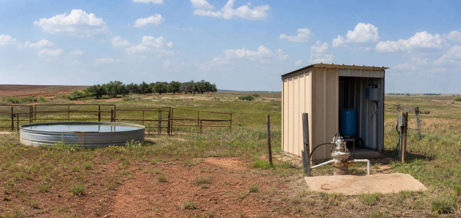
The Seymour Aquifer is one of those Texas aquifers that can fool a property owner in both directions. People hear that it is shallow and assume every well will be cheap and easy. Or they hear that it is tied to nitrate, chloride, and irrigation pressure and assume the whole thing is a mess. Both shortcuts miss the real story. The Seymour is a patchwork of shallow alluvial pods across the Rolling Plains of North Central Texas, and the value of a tract often comes down to which pod you are actually in, what nearby wells show, and whether the water quality on that specific property cooperates.
That is why the Seymour matters to buyers, sellers, ranch owners, agents, and rural homeowners. If you are looking at land in Wilbarger, Knox, Haskell, Baylor, Jones, Wichita, Foard, Hardeman, Hall, or the neighboring Rolling Plains counties, this aquifer can support domestic supply, municipal supply, stock use, and heavy irrigation. But it does not behave like a deep continuous sand aquifer, and it definitely does not behave like a limestone system such as the Trinity Aquifer. The Seymour is shallow, pod-driven, and far more sensitive to farming history and chemistry than the average buyer expects.
This guide is built for property owners who need a practical answer instead of a geology lesson that goes nowhere. It uses current Texas Water Development Board facts, TurnkeyWells groundwater records, and footprint-level well counts to explain what the Seymour Aquifer is, why it became productive, where the strong pods sit, what the North Central Texas well record says about depth, why the Haskell-Knox warning matters, and how TurnkeyWells tools help before you trust the wrong well story.
Quick Facts About the Seymour Aquifer in Texas
| Planning item | Practical property-owner meaning |
|---|---|
| Aquifer type | Unconfined shallow pod system, not one continuous regional layer |
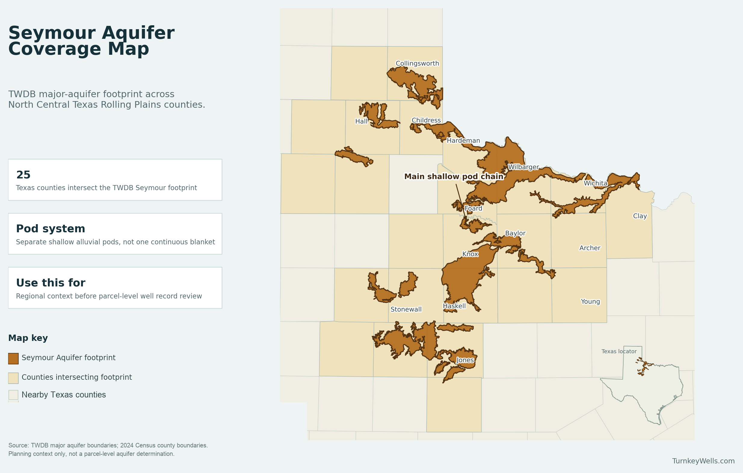
| Texas extent | 3,374 square miles across 25 counties in North Central Texas |
| Groundwater district coverage | About 62 percent of the aquifer sits inside groundwater conservation district jurisdiction |
| Geology | Isolated alluvial sediments up to about 360 feet thick, made of gravel, conglomerate, sand, and silty clay |
| TurnkeyWells exact Seymour-tagged sample | 4,780 GWDB rows, with 3,757 carrying usable depth values |
| Typical exact-tag depth signal | Median about 44 feet, with the middle half about 33 to 57 feet and the 90th percentile near 73 feet |
| Domestic exact-tag depth signal | Median about 38 feet, with the middle half about 27 to 53 feet |
| Submitted driller report domestic total-depth signal inside the official footprint | 954 domestic rows with a 57-foot median and a 110-foot upper planning marker |
| Main water-quality risks | Nitrate, chloride, sulfate, dissolved-solids variation, and localized saline pockets, especially where cultivation and irrigation history are heavy |
| Pumpage reality | TWDB says about 90 percent of groundwater pumped from the aquifer is used for irrigation, which is why the domestic and irrigation stories must be separated |
What the Seymour Aquifer Actually Is
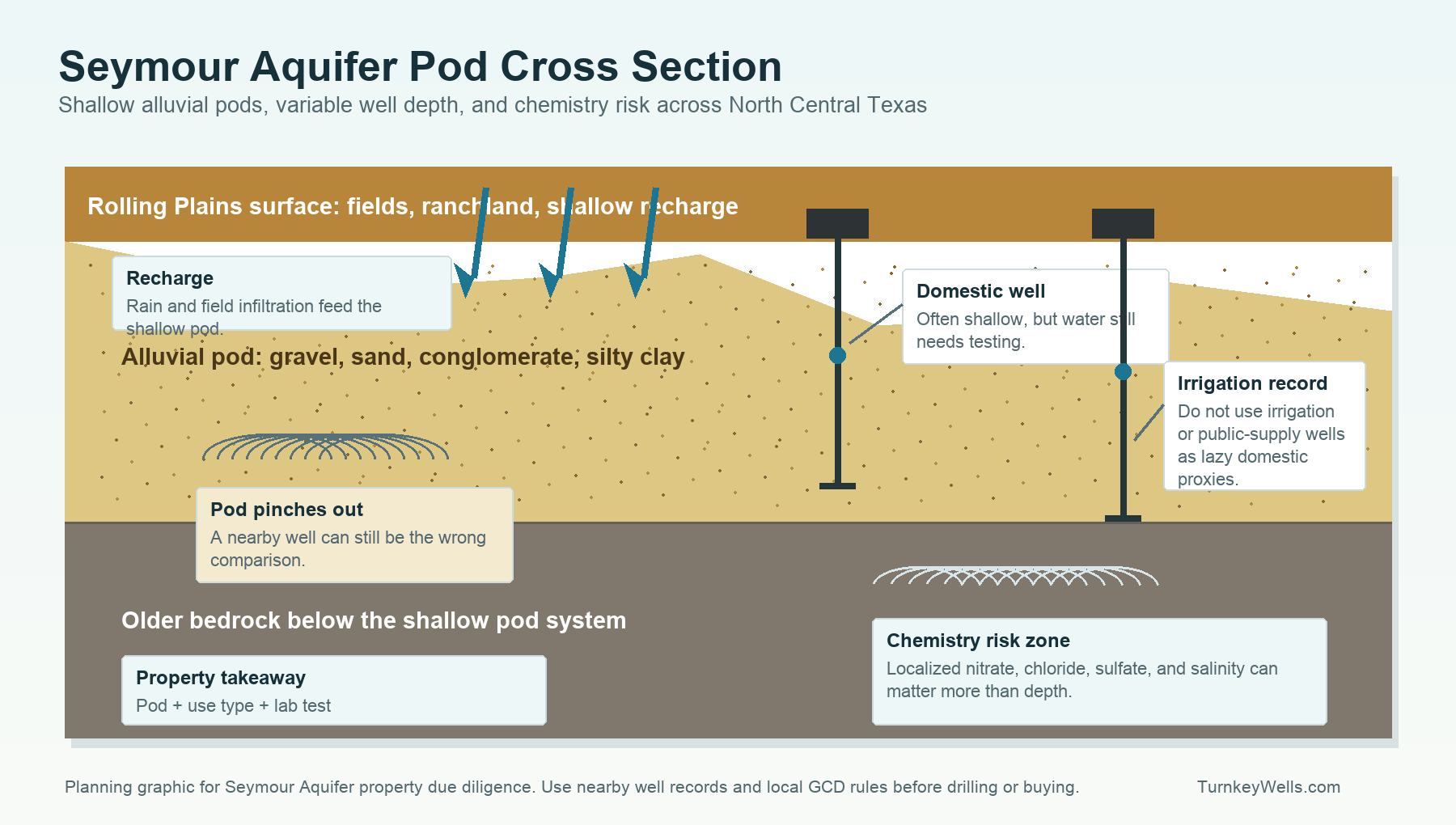
The Texas Water Development Board describes the Seymour as a major aquifer extending across North Central Texas with water stored in isolated pods of alluvial sediment. That wording is more important than it may sound. This is not an aquifer where you assume the same layer continues cleanly for county after county. The Seymour is made of discontinuous beds of gravel, conglomerate, sand, and silty clay that were laid down in alluvial settings and now sit as separate water-bearing pods over older bedrock.
For a property owner, that pod structure changes the whole planning approach. A neighbor with a shallow well does not automatically tell you what your tract will do if the pod pinches out or the better water-bearing interval sits off to one side. County averages also get weird fast because a pod with strong irrigation development can dominate the record even when a smaller domestic cluster nearby behaves differently. On the Seymour, broad labels help you ask the right question, but they do not replace local wells.
It also means the aquifer is naturally shallow compared with many other Texas major aquifers. That sounds like good news, and sometimes it is. In the TurnkeyWells exact Seymour-tagged sample, the median depth is only about 44 feet. Domestic wells in that same exact-tag sample show a median of about 38 feet. That is far shallower than the kind of numbers you see on the Gulf Coast Aquifer or the Ogallala Aquifer. But shallow does not mean uniform, and it definitely does not mean no treatment problems.
Why the Seymour Became a Real Aquifer Story
One of the unusual parts of the Seymour history is that TWDB says the aquifer was reportedly not productive before significant land clearing and farming. The agency notes that saturated thickness was once inadequate to support pumping, then increased gradually after land clearing reduced evapotranspiration losses and allowed more recharge to remain in the shallow system. That is a very different origin story from the classic Texas aquifer narrative where the rock was always the star and the only question was when people drilled into it.
That history matters because it explains why the Seymour feels so tied to agriculture. This is not just a shallow water source under farm country. In many ways the aquifer became more usable because the landscape and water balance changed with cultivation. The upside is that some of the Rolling Plains gained a workable shallow-water source. The downside is that the same farming history helped create the water-quality risks that show up today, especially nitrate from fertilizer leaching and heavy irrigation-driven chemistry problems in the core pods.
The practical lesson is that the Seymour should be approached as a working agricultural aquifer that also serves homes, small towns, and ranch improvements. If you buy land here, you are inheriting the geology and the land-use history together. That is why water quality can be the expensive surprise even when the well depth looks manageable.
What TurnkeyWells Records Show About Seymour Well Depth
The cleanest statewide Seymour count in the TurnkeyWells database comes from exact GWDB tags. There are 4,780 rows tagged exactly Seymour, and 3,757 of those have a usable depth value. Across that exact-tag sample, the average depth is about 48.5 feet and the median is about 44 feet. The middle half runs from roughly 33 to 57 feet, and the 90th percentile lands near 73 feet.
That is the first major planning point. The Seymour is genuinely shallow by Texas aquifer standards. But the use mix matters. Exact-tag domestic wells show a median of about 38 feet. Irrigation wells show a median near 47 feet. Public-supply wells are still shallow compared with many Texas aquifers, with a median around 46 feet. Stock wells track close to that with a median around 45 feet. These are not deep-project numbers. They are shallow-pod numbers, and that is exactly why people sometimes stop thinking too soon.
The footprint-wide submitted driller record adds a second useful check. Inside the official Seymour polygon, TurnkeyWells finds 6,608 submitted driller reports and 2,560 plugged-well records. In those submitted driller reports, the dominant footprint uses are irrigation at 2,163 reports, monitor wells at 1,330, stock wells at 1,208, and domestic wells at 955. That mix is important because it shows just how much of the local story is shaped by irrigation and agricultural activity rather than strictly residential groundwater use.
Domestic submitted driller reports inside the footprint still stay shallow overall, but they run a little deeper than the exact-tag GWDB domestic slice. TurnkeyWells sees 954 domestic total-depth rows with a median of 57 feet, a middle band of roughly 42 to 80 feet, and a 90th-percentile planning marker near 110 feet. Pump settings in those domestic footprint rows show a median around 52 feet. That is still shallow territory, but it is not zero-risk territory.
Representative county depth table
| County | Exact-tag sample | Average / median depth | Dominant use in sample | Planning read |
|---|---|---|---|---|
| Wilbarger County | 829 exact-tag depth records | 51 ft avg / 44 ft median | Irrigation | A large irrigated pod with a lot of agricultural noise. Good local evidence, but not a one-size domestic budget number. |
| Knox County | 828 exact-tag depth records | 42 ft avg / 42 ft median | Irrigation | One of the core Seymour counties. Still shallow by Texas standards, but nitrate and chemistry deserve as much attention as depth. |
| Haskell County | 671 exact-tag depth records | 50 ft avg / 51 ft median | Irrigation | A strong irrigation county where shallow does not mean carefree. This is where the Haskell-Knox water-quality warning becomes practical. |
| Jones County | 643 exact-tag depth records | 48 ft avg / 44 ft median | Unused | Mixed domestic, stock, and unused records. Useful for buyers on the southern edge of the aquifer where the pod geometry gets less predictable. |
| Baylor County | 405 exact-tag depth records | 33 ft avg / 33 ft median | Irrigation | A shallower pod pattern. Good reminder that some Seymour tracts can be affordable to drill, but not automatically safe to drink untreated. |
| Wichita County | 92 exact-tag depth records | 44 ft avg / 44 ft median | Public Supply | Public-supply heavy in the exact tag sample. A good warning not to let municipal or city-edge records stand in for a small domestic well. |
| Collingsworth County | 26 exact-tag depth records | 109 ft avg / 110 ft median | Irrigation | A much deeper northern fringe signal. This is where the shallow Seymour stereotype breaks down fast. |
| Hall County | 34 exact-tag depth records | 129 ft avg / 128 ft median | Irrigation | Another deeper northern pod. Good example of why county and pod matter more than the aquifer name alone. |
The spread in that county table is the second major planning point. Baylor, Knox, and parts of Wilbarger really do look shallow. Hall and Collingsworth do not. Wichita has a public-supply-heavy exact-tag slice that should not be used as a lazy stand-in for a domestic homesite. Jones shows what happens at the southern fringe when the county mix gets noisier. The aquifer name is useful, but the pod and county still decide the budget.
Why Shallow Does Not Mean Easy
Buyers love shallow numbers because shallow usually sounds like cheaper drilling, smaller pumps, and faster project timelines. The Seymour does offer that upside in the right tract. But shallow aquifers come with their own traps. A shallow system is often more exposed to land-use effects, more vulnerable to localized contamination, and more sensitive to bad well construction or weak surface drainage than a deeper confined aquifer. The Seymour checks all of those boxes.
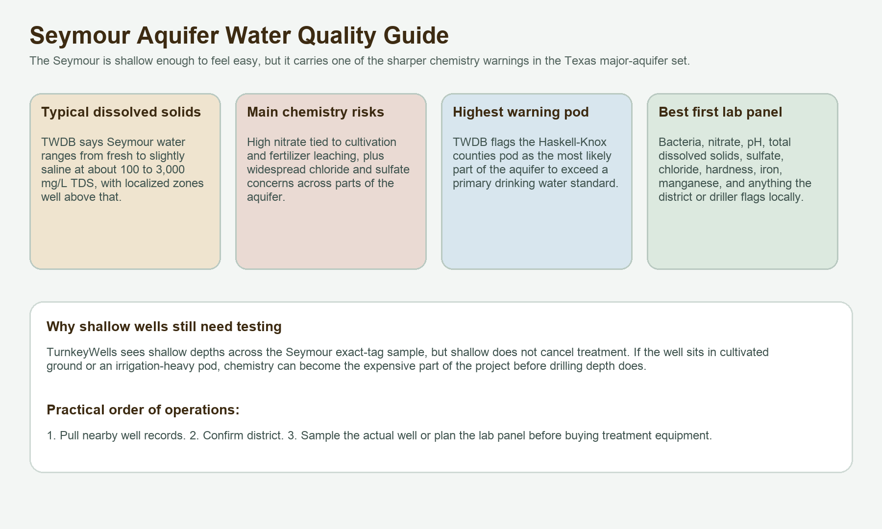
TWDB says water in the Seymour ranges from fresh to slightly saline, with total dissolved solids from about 100 to 3,000 milligrams per liter, while localized areas run from 3,000 to more than 10,000 milligrams per liter. That means the nice shallow well story can break hard if your tract sits in the wrong water-quality pocket. A fifty-foot well is not a gift if it leads straight to nitrate, sulfate, chloride, or high-TDS treatment costs.
That chemistry-first reality is why the Seymour should be treated as a quality-and-quantity problem together. Depth tells you whether a well may be practical. Water quality tells you whether it will be practical to live with. On some tracts the answer to both questions is yes. On others, the well may be shallow enough to drill and still expensive to use.
Water Quality: The Part of the Seymour Buyers Ignore at Their Own Expense
The water-quality warning on the Seymour is unusually direct. TWDB says high nitrate concentrations are tied to oxidation of soil organic nitrogen during initial cultivation followed by fertilizer leaching on cultivated land. It also says excessive chloride and sulfate occur throughout the aquifer. That is not subtle language. It is the agency telling you this aquifer has a real land-use chemistry story, not just a vague possibility of nuisance minerals.
The Haskell-Knox pod is the headline example. TWDB says the Haskell-Knox counties pod has the highest probability of exceeding any primary drinking water standard. That does not mean every well in Haskell or Knox is bad. It means the water-quality risk is strong enough there that nobody should buy or build on the assumption that shallow equals automatically drinkable with no real testing.
Nitrate is the first major issue because it is a real drinking-water concern rather than a simple nuisance. Chloride and sulfate matter for taste, corrosion, scaling, and livestock-use context. Dissolved solids affect taste and long-term equipment wear. Because the Seymour is shallow and heavily tied to cultivated land, bacterial screening and basic domestic well-health checks still matter too, especially on older wells or properties where the wellhead protection is sloppy.
That makes the right test panel fairly straightforward. For a Seymour domestic well, start with bacteria, nitrate, pH, total dissolved solids, hardness, chloride, sulfate, iron, manganese, and anything the local district or driller says is showing up in the same pod. If the property already has a well and water quality matters to the deal, that test should happen before closing. Waiting until after the purchase to discover a nitrate or chloride problem is exactly the kind of avoidable own-goal that this page is trying to help people avoid.
Irrigation Pressure and Why the Comparison Set Matters
TWDB says almost all of the groundwater pumped from the Seymour, about 90 percent, is used for irrigation. That one fact should change how you read every local well story. An irrigation aquifer record is not the same thing as a domestic aquifer record. Irrigation wells, irrigation pumping history, and irrigation-driven chemistry changes can all distort what a homeowner or land buyer thinks he is seeing.
In the exact-tag TurnkeyWells sample, irrigation is the biggest use bucket by far at 1,715 usable depth rows. Inside the official footprint, irrigation also dominates the submitted driller-report record. That is why a county average or a broad sample can tell the wrong story to a domestic buyer. The correct question is never just, “How deep are Seymour wells here?” The correct question is, “How deep are nearby domestic wells in this pod, and what do they say about water quality?”
This is also why a tract with a known irrigation history nearby deserves extra skepticism about water-level assumptions, water-quality assumptions, and project budgeting. A small home well is not the same planning problem as a field-scale irrigation project, even when both wells sit inside the same aquifer footprint. The Seymour record is useful only when you sort the right wells into the right bucket.
Groundwater Districts and Rule Check
About 62 percent of the Seymour Aquifer lies within groundwater conservation district coverage, according to TWDB. That means district review is not optional if you are serious about drilling, reworking, or buying land that depends on a private well. Domestic exemptions may exist in some places, but registration, spacing, notice, or use-based rule differences can still matter. And the Seymour footprint is broad enough that the rulebook is not the same in every county pod.
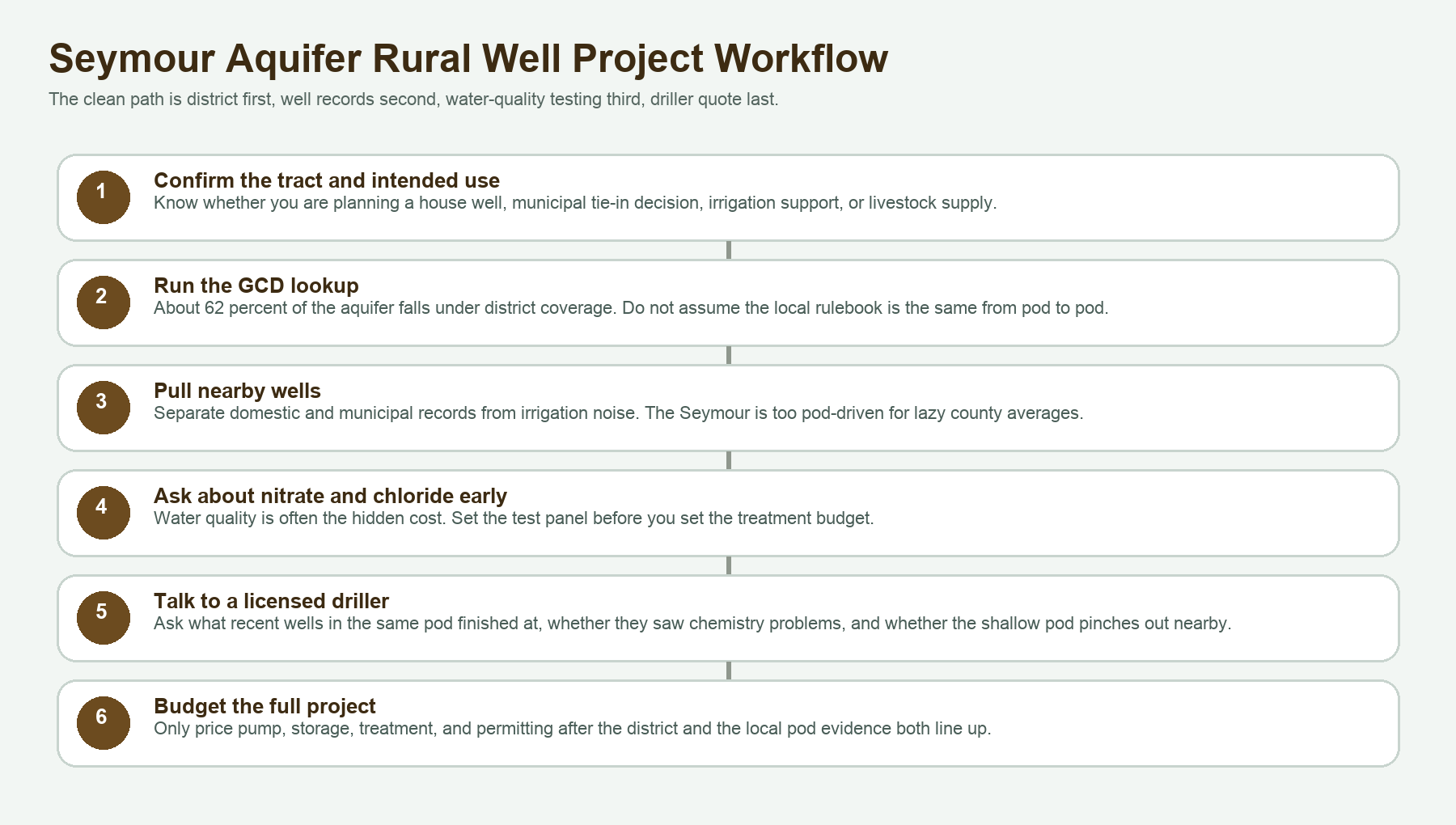
The first move is still simple: run the Free GCD Lookup on the actual property. Do that before you call the driller for a final quote and before you assume the same exemption your neighbor talked about five years ago still applies to your tract. The right sequence on the Seymour is district first, well records second, water test third, quote fourth.
That sequence is especially important because a shallow aquifer tempts people to move too fast. It is easy to hear that the well might only be fifty or sixty feet deep and start treating the job like a minor utility hookup. But if the district has spacing issues, the pod evidence is mixed, or nitrate and chloride are already part of the local conversation, the real project cost is larger than the shallow depth alone suggests.
Check the Rules and the Pod Before You Drill
The Seymour can look easy on depth and ugly on chemistry. Confirm the district, the nearby wells, and the actual pod before you trust a shallow-number sales pitch.
What This Means When Buying Land With an Existing Well
An existing Seymour well can be a real asset, but only if you know what it is serving and how it performs. If the property has a shallow domestic well, ask for the driller report if it exists, the pump depth if anyone knows it, a recent lab test, and a clear picture of surface drainage and wellhead protection. Because this aquifer is shallow and influenced by land use, the condition of the wellhead and the chemistry of the water matter just as much as the raw depth.
If the property has only an old irrigation or stock well, do not let anyone pretend that automatically solves the household supply question. An old irrigation well may prove the pod is productive, but it does not prove the water is pleasant, safe, or cheap to condition for a house. A stock well can be a great ranch clue and still not answer the domestic question cleanly. On the Seymour, the use history has to match your intended use.
This also matters for transaction paperwork. If a seller is completing TREC Form 61-0, the cleanest deal is the one where the well record, the district, and the actual water condition are documented before everybody is improvising during escrow.
What This Means When Drilling a New Seymour Well
A new Seymour well starts with local record discipline. Pull the nearby wells. Separate domestic, municipal, and irrigation evidence. Check the district. Then decide whether the tract is in one of the cleaner shallow pods or in an area where chemistry and pod continuity deserve more skepticism. Only after those steps should you treat the shallow depth as good news.
For many Rolling Plains tracts, the Seymour can be a workable domestic aquifer because the depth signal stays modest. That is the upside. The hidden part of the budget is what happens after the drill if nitrate, chloride, sulfate, or total dissolved solids need treatment. The smartest Seymour project budgets for both possibilities instead of treating the job like depth is the whole story.
It is also worth remembering that the aquifer behaves in pods. If a driller says the nearest strong well is shallow and productive, ask how close it really is and whether it is in the same pod geometry as your tract. On this aquifer, that question is not nitpicking. It is the whole game.
Current TurnkeyWells County Links in Seymour Country
TurnkeyWells only links county pages here when the page is both live and genuinely relevant to the aquifer. One current verified Seymour-country county page is Water Well Drilling in Clay County, Texas, which returns live and sits on the northern fringe of the aquifer story. The Seymour footprint also touches a wider Rolling Plains county set where TurnkeyWells still needs more county coverage before forcing more links here would be honest.
That restraint matters. The Seymour is too pod-specific for filler interlinking. When additional Haskell, Knox, Wilbarger, Baylor, or Jones county pages are genuinely published and verified, they should belong here. Until then, it is better to keep the aquifer hub accurate than to spray unrelated county links across it just to hit a quota.
How the Seymour Compares to Other Texas Aquifers
The Seymour is not the same planning problem as the Ogallala Aquifer. The Ogallala conversation is dominated by saturated-thickness decline, broad High Plains irrigation history, and a much more famous depletion narrative. The Seymour is smaller, pod-based, shallower, and more tightly tied to localized chemistry and agricultural recharge history.
It is also not the same as the Gulf Coast Aquifer, where stacked coastal sands, municipal depth inflation, and saltwater encroachment shape the story. And it is definitely not the same as the Trinity Aquifer, where limestone and sandstone in North Texas create a different depth-and-recharge pattern. The Seymour has its own personality: shallow, pod-driven, agriculture-heavy, and chemistry-sensitive.
How TurnkeyWells Helps on Seymour Properties
The Seymour is exactly the kind of aquifer where public data exists but easy interpretation does not. A landowner can pull a few well logs and still misread the tract if he blends irrigation wells with domestic wells, skips the district check, or assumes that a shallow well must have easy chemistry. TurnkeyWells helps organize that mess into a property decision you can actually use.
The Free Well Check is the fast starting point. It shows nearby registered wells at a Texas address so you can see whether the local pod reads shallow, dense, irrigation-heavy, municipal, or sparse. The Pre-Drill Intelligence Report goes further by organizing the nearby record, the aquifer context, and the local planning risk into a parcel-focused view. And the Free GCD Lookup tells you who governs the tract before you assume anything about spacing or exemptions.
Research the Property Before You Commit
On the Seymour, the cost of a bad assumption usually shows up in chemistry, pod continuity, or the wrong comparison set. Start with the nearby well record and district before you trust the shallow depth story.
Frequently Asked Questions About Seymour Wells in Texas
How deep is a typical Seymour Aquifer well in Texas?
It is shallow by Texas standards, but the exact answer depends on the pod and the well use. In the TurnkeyWells exact Seymour-tagged sample, the median depth is about 44 feet. Domestic exact-tag wells show a median around 38 feet, while submitted domestic driller reports inside the official footprint run a little deeper with a median around 57 feet.
Is Seymour Aquifer water safe to drink?
Sometimes yes, but not by reputation alone. TWDB flags nitrate, chloride, sulfate, and dissolved-solids issues across parts of the aquifer and specifically warns about the Haskell-Knox pod. Test the actual well before relying on it for household use.
Why does the Seymour matter so much for farmland and ranchland?
Because it is a shallow Rolling Plains aquifer heavily tied to agriculture. TWDB says about 90 percent of groundwater pumped from the aquifer goes to irrigation, and the farming history also helps explain some of the nitrate and chemistry concerns.
Do I need a permit to drill a Seymour well?
Sometimes yes, sometimes a domestic exemption may apply, and sometimes registration or spacing rules still matter even when permitting looks lighter. About 62 percent of the aquifer lies under district coverage, so the right answer is parcel-specific. Start with the Free GCD Lookup.
What is the biggest mistake buyers make with Seymour land?
Confusing shallow depth with low risk. On the Seymour, the expensive surprise is often chemistry, pod continuity, or using irrigation and municipal wells as the wrong comparison set for a domestic homesite.