Texas Hill Country and San Antonio corridor groundwater planning
A practical guide to well depth, recharge-zone risk, spring behavior, municipal-versus-domestic record reading, groundwater rules, and how to avoid the wrong land decision on one of Texas’s fastest-moving aquifers.

The Edwards (Balcones Fault Zone) Aquifer is one of the rare Texas aquifers that can sound simple and still fool people fast. Buyers hear “Edwards” and think clean limestone water, spring-fed beauty, and a proven water source under some of the most valuable land in South Central Texas. That is partly true. They also hear stories about San Antonio drawing almost everything from the aquifer, drought pumping restrictions, recharge-zone contamination fights, and the mysterious bad-water line. That is true too. The mistake is treating those stories like they all describe the same tract the same way.
This aquifer is really a set of different property problems stitched together by one name. A Hill Country homesite in the recharge zone, a San Antonio fringe tract inside the public-supply corridor, a northern-segment parcel near Austin, and a deeper agricultural property farther west can all be called Edwards while behaving very differently on well depth, drought sensitivity, permitting, contamination vulnerability, and long-term planning risk. The right move is not to hunt for one famous aquifer average. It is to figure out which part of the Edwards story your property actually belongs to.
That is why this page is built for land buyers, existing well owners, agents, sellers, rural homeowners, and anyone pricing a serious Texas property decision. It pulls together current Texas Water Development Board facts, the official Edwards footprint, and the TurnkeyWells groundwater record so you can see how the aquifer behaves in the real world: where the shallow recharge country sits, where the public-supply and irrigation record runs much deeper, why the spring system matters, where the fresh-water line starts to change, and how our tools help before you trust the wrong well story.
Quick Facts About the Edwards Aquifer in Texas
| Planning item | Practical property-owner meaning |
|---|---|
| Aquifer type | confined and unconfined. The outcrop and recharge side behaves differently from the confined down-dip side. |
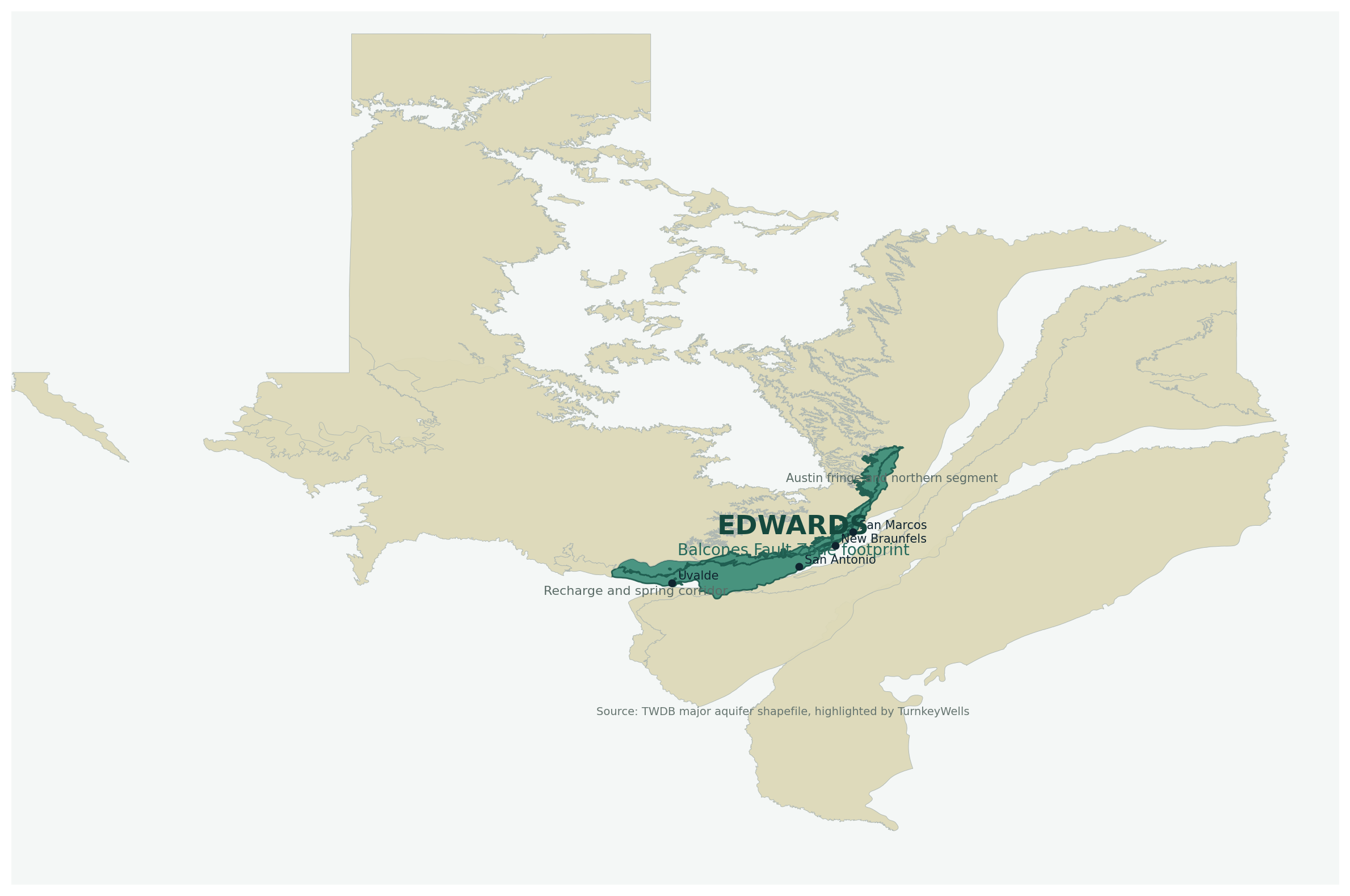
| Texas extent | 1,566 square miles of outcrop plus 2,481 square miles of subsurface area across 14 counties. |
| Groundwater district coverage | About 87 percent of the aquifer sits inside groundwater conservation district jurisdiction, so parcel-level rule checks are standard, not optional. |
| Geology and thickness | Highly permeable dissolved limestone, generally about 200 to 600 feet thick, with freshwater saturated thickness averaging about 560 feet in the southern segment. |
| TurnkeyWells exact tagged records | 4,076 GWDB wells tagged exactly Edwards (Balcones Fault Zone), with 3,653 usable depth values. |
| Typical exact-tag depth signal | Median about 475 feet, with the middle half running from about 300 to 840 feet and the 90th percentile near 1,400 feet. |
| Domestic exact-tag depth signal | Median about 360 feet, with the middle half about 265 to 460 feet. |
| Submitted driller-report domestic signal inside the official footprint | 6,818 domestic rows with a 530-foot median and a 900-foot upper planning marker. |
| Main water-quality theme | Usually hard but fresh water inside the official boundary, with contamination vulnerability in the recharge zone and salinity risk as you move toward the bad-water line beyond the fresh boundary. |
| Famous springs and rapid response | Comal, San Marcos, Hueco, San Pedro, San Antonio, and Leona springs all connect to the Edwards story. Water levels and springflow can rise or drop quickly with rainfall, drought, and pumping. |
What the Edwards (Balcones Fault Zone) Aquifer Actually Is
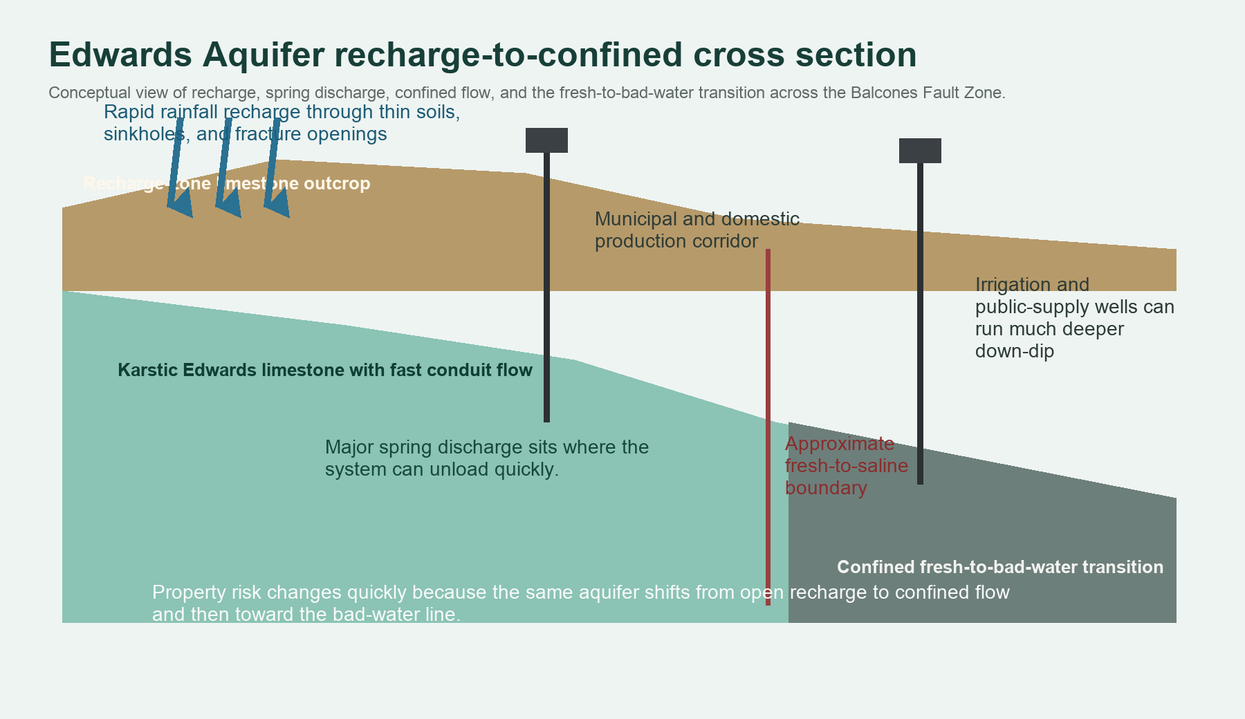
The Texas Water Development Board describes the Edwards (Balcones Fault Zone) as a major aquifer in South Central Texas made primarily of partially dissolved limestone. That dissolved-limestone detail is the whole game. The Edwards is not just another rock layer with water in it. It is a karst aquifer, which means water can move quickly through fractures, channels, and solution openings in the limestone. That is why the aquifer can deliver major springflow and major public-supply production, and it is also why contamination and drought signals can show up faster than people expect.
For property owners, the cleanest first distinction is unconfined versus confined. In the unconfined recharge area north and west of the Balcones Fault Zone, rain can move into the aquifer more directly through the karstic outcrop. That is great for keeping the system refreshed and keeping total dissolved solids low. It is also great for carrying contamination risk if the surface use is careless. In the confined section farther down-dip, water is under pressure, the flow path is longer, and the fresh-water line eventually gives way to the bad-water boundary where salinity increases beyond the official aquifer edge.
That split is why the Edwards feels like a premium aquifer and a high-attention aquifer at the same time. It has some of the strongest groundwater reputation in Texas, but it does not reward lazy due diligence. A tract’s exact position relative to the recharge zone, the faulted corridor, the spring system, and the fresh-water boundary matters more here than on many slower and more uniform sand aquifers.
Why This Aquifer Matters So Much in Texas Property Decisions
The Edwards matters because it is tied directly to growth, agriculture, drought politics, and spring health. San Antonio gets almost all of its water supply from this aquifer. That means property owners are not operating in some quiet backwater geology lane. They are inside one of the most important groundwater management stories in Texas. When rainfall is good, the aquifer can recover quickly. When drought and pumping line up the wrong way, water levels and springflow can drop fast enough to change planning assumptions, pumping restrictions, and the emotional tone of the entire region.
It also matters because the same aquifer supports radically different uses. In the TurnkeyWells exact-tag sample, domestic wells are a major bucket, but public-supply and irrigation wells are also huge. That is why buyers get fooled when they use the first nearby Edwards record they find. The right comparison for a rural home, a horse property, a subdivision-edge tract, and an agricultural operation is not always the same. On the Edwards, the use mix has to be separated before the depth numbers mean anything honest.
The land-value side is just as important. A tract with proven Edwards access can be more attractive than a property depending on a deeper, slower, or saltier aquifer. But that value premium only holds if the parcel sits in the right part of the Edwards story, under the right rules, with the right water-quality evidence and the right drought expectations. That is what good due diligence is for.
Springflow, Recharge, and Why the Edwards Responds So Fast
The springs are not trivia. Comal Springs in Comal County is the largest spring in Texas, and San Marcos Springs in Hays County is the second largest. Hueco, San Pedro, San Antonio, and Leona springs also discharge from the aquifer. These springs exist because the Edwards can move water quickly through the karst system and unload it where the geology allows. That same rapid movement is why water levels and springflows respond so quickly to rainfall, drought, and pumping.
For a property owner, that fast response has two meanings. First, the aquifer can rebound quickly after meaningful recharge. This is not a system where every drought drop implies a decades-long recovery story. Second, the aquifer can also show stress quickly when rainfall is poor or demand is high. If your parcel sits in a drought-sensitive part of the Edwards, the right question is not only whether a well exists. It is how nearby wells and nearby spring behavior reacted when the weather got ugly.
This is where rural property buyers often miss the plot. They hear “Edwards” and assume permanent abundance because the springs are famous. But a spring-fed aquifer is not a magical aquifer. It is a responsive aquifer. That can be a strength, and it can also be a warning that local rules, pumping history, and recharge protection deserve more respect than the average tract listing gives them.
What TurnkeyWells Records Show About Edwards Well Depth
The cleanest statewide count comes from exact groundwater database tags. TurnkeyWells has 4,076 wells tagged exactly Edwards (Balcones Fault Zone), and 3,653 of those carry a usable depth value. Across that usable sample, the average depth is about 648.8 feet and the median is about 475 feet. The middle half of the exact-tag sample runs from roughly 300 to 840 feet, while the 90th percentile reaches about 1,400 feet.
Those aquifer-wide numbers are useful, but they hide an enormous use split. Exact-tag domestic wells show a median around 360 feet. Stock wells show a median around 400 feet. Public-supply wells show a median around 591 feet. Irrigation wells push much deeper, with a median near 916 feet and an upper band that runs well above a typical homesite budget. That split is the biggest reason generic Edwards averages mislead people.
The footprint-wide submitted driller-report record adds another reality check. Inside the official Edwards polygon, TurnkeyWells finds 30,818 submitted driller reports and 10,485 plugged-well records. Inside that footprint, the biggest submitted-use buckets are domestic at 6,820 reports, irrigation at 1,235, public supply at 225, stock at 562, and monitor wells at 5,918. That is not a sleepy one-use aquifer. It is a crowded, heavily worked groundwater corridor.
Domestic submitted driller reports inside the official footprint show 6,818 total-depth rows with a median of 530 feet, a middle band from about 320 to 800 feet, and a 90th-percentile planning marker near 900 feet. Pump settings in those same domestic footprint rows show a median around 500 feet. That is a solid planning lane for real residential decisions, but it is still too broad to use without county and segment context.
Representative county depth table
| County | Exact-tag sample | Average / median depth | Dominant use in sample | Planning read |
|---|---|---|---|---|
| Bexar County | 1,044 exact-tag depth records | 897 ft avg / 788 ft median | Public Supply | The heavy municipal heart of the aquifer. Excellent for showing the scale of the San Antonio segment, but a city supply record is not a domestic homesite budget. |
| Medina County | 580 exact-tag depth records | 901 ft avg / 682 ft median | Irrigation | One of the strongest irrigation-and-domestic crossover counties. Good local evidence, but it can overstate what a light-use house well will need. |
| Travis County | 408 exact-tag depth records | 394 ft avg / 380 ft median | Domestic | The northern segment runs much shallower and tighter here. Useful for Austin fringe and recharge-zone property decisions, especially where contamination risk matters more than raw depth. |
| Williamson County | 405 exact-tag depth records | 316 ft avg / 222 ft median | Domestic | A reminder that the Edwards can look surprisingly manageable on the northern end, but parcel-level rule and recharge sensitivity still matter. |
| Uvalde County | 393 exact-tag depth records | 716 ft avg / 593 ft median | Irrigation | A high-volume agricultural county where strong irrigation history can distort what a domestic buyer thinks is typical. |
| Hays County | 345 exact-tag depth records | 419 ft avg / 400 ft median | Domestic | One of the cleaner domestic planning counties in the sample and a good example of how quickly springflow and urban recharge protection become part of the conversation. |
| Comal County | 222 exact-tag depth records | 375 ft avg / 325 ft median | Domestic | Comal County carries classic spring-fed Edwards value, but it also punishes sloppy assumptions about recharge, septic risk, and drought sensitivity. |
| Bell County | 135 exact-tag depth records | 242 ft avg / 171 ft median | Domestic | A northern fringe county where the Edwards reads much shallower than the San Antonio corridor and proves how misleading one aquifer-wide average can be. |
The spread in that table is the point. Bell and Williamson show that the northern Edwards can read much shallower than people imagine when they only think about the San Antonio segment. Bexar and Medina remind you how much city-scale and irrigation-scale infrastructure can inflate an aquifer-wide number. Hays and Comal look attractive for domestic planning, but those same recharge and spring strengths come with stricter contamination attention. Uvalde proves how quickly agricultural demand can change the comparison set. There is no honest single-number Edwards answer for the whole state corridor.
Domestic Versus Municipal Versus Irrigation: The Comparison Problem
One of the easiest ways to get burned on an Edwards property is to mix uses. A public-supply well in Bexar County, a city-edge irrigation well in Medina County, and a domestic well in Hays County can all be “Edwards” while implying very different casing, pump, demand, and budget stories. If a seller or broker waves around one big water well number without saying what the well was drilled for, you do not have useful evidence yet. You have a conversation starter.
This matters even more because the Edwards is a famous aquifer. Famous aquifers attract folklore. Somebody always knows about a giant city well, a legendary spring-fed ranch tract, or a drought year when everything got weird. Those stories are not always wrong. They are just often irrelevant to the actual parcel in front of you. The right Edwards comparison is the nearby domestic or same-use well set on the same part of the aquifer story, not the loudest number in the room.
TurnkeyWells helps by sorting that record set before it becomes an expensive assumption. The job is not to collect more wells than anybody else. The job is to separate the wrong wells out of the decision before they take over the budget.
Water Quality: Usually Good, But Not a Free Pass
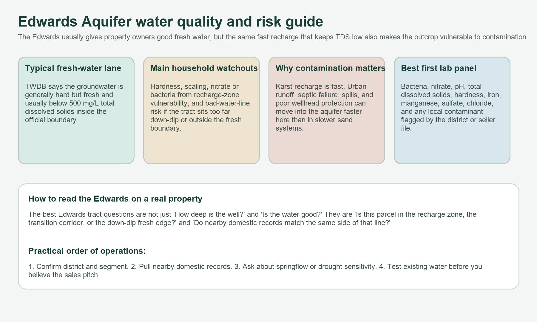
TWDB says water quality in the Edwards is generally very good. Inside the official boundary, the groundwater is usually hard but fresh and contains less than 500 milligrams per liter of total dissolved solids. That is strong by Texas private-well standards. It is one reason the Edwards has such a good reputation. If your tract sits in the fresh unconfined or productive confined part of the aquifer, the water story can be very favorable.
But the Edwards does not hand out a free pass. First, it is still hard water. That means scale on fixtures, heater wear, and household treatment questions can still matter. Second, the outcrop and recharge-zone vulnerability is real. TWDB says the rapid recharge and flow through karstic features make the aquifer vulnerable to contamination, especially from nonpoint source pollution and runoff in urbanized areas. That means bacteria, nitrate, septic issues, spills, and careless surface management deserve more attention here than on slower aquifers where surface water takes longer to translate into groundwater risk.
Third, the bad-water line matters. South and east of the official fresh-water boundary, increased residence time and interaction with evaporite members of the Edwards Formation drive salinity upward. A tract does not have to be far into the wrong side of the system before the chemistry changes from “great Edwards water” to “this is now a treatment and usability problem.” That is why parcel position matters just as much as aquifer name.
For an existing Edwards well, the right first lab panel is basic but non-negotiable: bacteria, nitrate, pH, total dissolved solids, hardness, sulfate, chloride, iron, manganese, and any local contaminant of concern identified by the district, seller file, or neighborhood history. If the parcel sits on or near the recharge zone, surface sanitation and drainage around the wellhead matter almost as much as the test results themselves.
Recharge-Zone Property Risk: The Part Buyers Underestimate
Recharge-zone property sounds attractive because it is close to the part of the aquifer that refills. That is not wrong. It is also where the aquifer is most exposed. Thin soils, fractured limestone, sinkholes, caves, and direct infiltration features mean surface mistakes can matter quickly. A poor septic setup, a badly protected wellhead, a spill, heavy runoff concentration, or simply a property that has not been managed carefully can create a bigger groundwater concern here than on a slower sand system.
That does not mean recharge-zone property is bad property. It means recharge-zone property needs sharper diligence. If a tract already has a well, look at the wellhead, drainage, casing condition, pad condition, and recent water tests. If the tract does not have a well yet, understand the district and local protection context before assuming the same easy drilling story applies across the whole neighborhood.
The Edwards is famous partly because it moves water fast. Buyers need to remember that fast flow is a risk pathway as much as a water-supply strength. The same feature that helps springs and recovery can also help contamination travel.
Groundwater Districts, Pumping Rules, and Why the Edwards Gets Managed Hard
About 87 percent of the aquifer lies within groundwater conservation district coverage. That alone tells you the Edwards is not a casual permit story. The exact rulebook varies by location, but the aquifer’s public-supply importance, drought sensitivity, and springflow value mean rule checks need to happen early. Domestic and livestock exemptions may still exist in places, but registration, spacing, permit classifications, pumping limits, or notice requirements can still affect timing and design.
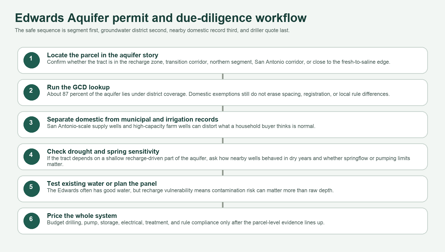
The safest move is always to run the Free GCD Lookup on the exact parcel before you trust any verbal rule summary. That matters even more on the Edwards because the aquifer crosses different management cultures. A northern-segment tract and a San Antonio-area tract may both sit on Edwards water while living under very different practical expectations. The district check is how you keep that from becoming an expensive surprise after the land is already under contract.
The order of operations matters too. On the Edwards, district first, well record second, water test third, and driller quote fourth is the safe sequence. Reverse it and the wrong assumption starts steering the whole project.
Check the Segment Before You Trust the Sales Pitch
The Edwards can be a premium water source, but only when the parcel sits in the right part of the aquifer story. Confirm the district, the nearby same-use wells, and the actual water condition before you buy or drill.
What This Means When Buying Land With an Existing Edwards Well
An existing Edwards well can be a serious value add, but only if you know what kind of Edwards well it is. Ask for the driller report if it exists, the pump depth if anyone knows it, a current lab test, and a clear explanation of how the system performed in recent dry periods. If the parcel sits in recharge-zone country, wellhead protection and drainage deserve a direct visual inspection, not a casual answer from the seller.
If the property has an older well tied to irrigation or a high-capacity historical use, do not assume that automatically solves the household question. The well may prove the aquifer is productive. It does not prove the water quality is household-friendly, the pump setup is sized correctly for modern domestic use, or the same rule path will apply if the system gets altered.
This also matters for disclosure. If a seller is completing TREC Form 61-0, the clean transaction is the one where the district, the well record, and the water condition are documented before everyone starts improvising during escrow.
What This Means When Drilling a New Edwards Well
A new Edwards project should start with local record discipline, not with a romantic idea about Hill Country water. Pull nearby same-use wells. Separate domestic from municipal and irrigation records. Check the district. Confirm whether the tract sits in a recharge-zone lane, a spring-sensitive lane, or closer to the down-dip fresh-water edge. Then talk to the driller with a real comparison set instead of a myth.
Many Edwards tracts do turn into strong private-well properties because the aquifer is productive and the fresh-water lane is good. But that upside becomes a liability when buyers skip the parcel-level details and treat the aquifer name like a guarantee. The expensive correction on the Edwards is often not that there is no water. It is that the parcel sits under a different rule set, a different use mix, or a different contamination and chemistry risk than the buyer assumed.
The best Edwards drill budget includes more than footage. It includes pump and storage planning, electrical work, possible treatment, drought expectations, and the rule path that applies to the tract. The whole aquifer rewards people who think one step earlier than the sales pitch.
Current TurnkeyWells County Links in Edwards Country
TurnkeyWells only links county pages here when the county page is both live and genuinely aligned with the same aquifer story. Right now the clean published county-page set is still weighted toward Gulf Coast, East Texas, and other aquifer corridors. Rather than forcing the wrong Hill Country or Austin-metro county links into this page, this hub stays honest and keeps the Edwards county set in plain text until the matching live county pages are actually ready and verified.
That restraint matters. The Edwards is too segment-sensitive for filler interlinking. When the correct Bexar, Comal, Hays, Medina, Uvalde, Travis, or Williamson county pages are genuinely published and verified, they belong here. Until then, it is better to keep the aquifer hub accurate than to spray unrelated county links across it just to satisfy a quota.
How the Edwards Compares to Other Texas Aquifers
The Edwards is not the same planning problem as the Trinity Aquifer. The Trinity story is more spread across limestone and sandstone belts with a different recharge pattern and a different depth mix. It is also not the same as the Edwards-Trinity Aquifer, which covers a much broader plateau-and-ranch corridor where domestic, stock, and irrigation wells tell a more geographically stretched story.
It is definitely not the same as the Gulf Coast Aquifer, where stacked coastal sands, saltwater encroachment, and municipal-depth inflation dominate the conversation, or the Ogallala Aquifer, where saturated-thickness decline and High Plains irrigation depletion shape the whole narrative. The Edwards is smaller, faster, karstic, spring-driven, and far more politically and environmentally sensitive than most Texas aquifers with comparable public familiarity. The Pecos Valley Aquifer guide covers a very different West Texas alluvial system where basin position, irrigation demand, and water chemistry drive the property review.
How TurnkeyWells Helps on Edwards Properties
The Edwards is exactly the kind of aquifer where plenty of public data exists and plenty of bad conclusions still get made. A buyer can pull a few logs, hear one famous spring story, get one driller quote, and still completely miss the actual parcel risk. TurnkeyWells helps sort the property into the right segment, the right use mix, and the right next question before money is committed.
The Free Well Check is the quick first step. It shows nearby registered wells at a Texas address so you can see whether the tract sits in a dense domestic lane, a public-supply corridor, a sparse western lane, or a recharge-zone pattern that deserves more caution. The Pre-Drill Intelligence Report goes farther by organizing the nearby record, aquifer context, and local risk into a tract-specific planning view. The Free GCD Lookup confirms the district before you assume anything about exemptions, spacing, or permit steps.
Research the Property Before You Commit
On the Edwards, the expensive mistake is usually not ignoring the aquifer. It is assuming every Edwards tract behaves the same. Start with the nearby well record and district before the wrong comparison becomes your budget.
Frequently Asked Questions About Edwards Wells in Texas
How deep is a typical Edwards Aquifer well in Texas?
It depends heavily on the county, the segment, and the use. In the TurnkeyWells exact Edwards (Balcones Fault Zone) sample, the median depth is about 475 feet. Domestic wells in that exact-tag sample show a median around 360 feet, while irrigation and public-supply wells often run much deeper.
Is Edwards Aquifer water good to drink?
Often yes, and that reputation is deserved inside the fresh-water boundary. TWDB says the water is generally hard but fresh and usually below 500 mg/L TDS inside the official aquifer boundary. But recharge-zone contamination and bad-water-line position still matter, so every actual well should be tested.
Why do people worry so much about recharge-zone property?
Because the Edwards is karstic and recharges fast. That is good for keeping the aquifer productive and bad for anyone who assumes spills, runoff, septic trouble, or poor wellhead sanitation will be filtered slowly before they matter.
Do I need a permit to drill an Edwards well?
Sometimes yes, sometimes a domestic or livestock exemption may apply, and sometimes registration and spacing rules still matter even when permitting looks lighter. About 87 percent of the aquifer sits under district coverage, so the only honest answer is parcel-specific. Start with the Free GCD Lookup.
What is the biggest mistake buyers make on Edwards land?
Treating the aquifer name like a guarantee. The expensive mistake is usually confusing one segment or one use type for another, then discovering too late that the tract belongs to a different rule, depth, or contamination story.
Data and planning language in this guide draw on Texas Water Development Board aquifer facts, official aquifer mapping, and local TurnkeyWells well-record checks. Well depth, yield, water chemistry, drought sensitivity, and permitting vary by property. This guide is a planning resource for landowners, buyers, agents, and rural property professionals. It is not a substitute for a licensed water well driller, a water-quality lab, or the applicable groundwater district.