East and Central Texas coastal-plain groundwater planning
A practical guide to Yegua-Jackson well depth, mixed county signals, water-quality watchouts, district rules, and what Texas property owners should verify before buying or drilling on a layered sand-and-clay tract.
The Yegua-Jackson Aquifer is one of those Texas groundwater pages that makes buyers pay for fuzzy thinking. Plenty of tracts across East and Central Texas sit in counties where more than one aquifer name shows up on the record, where shallow domestic wells and deeper public-supply wells both exist, and where an old county average can quietly ruin a new drill budget. A property owner who hears only “coastal plain wells are usually fine” or only “that county has deep water” is probably listening to the wrong person.
That is why this aquifer deserves attention. The Yegua-Jackson corridor runs through a large part of East and Central Texas where ranch buyers, rural homeowners, land investors, agents, and existing well owners all need tract-level groundwater answers instead of folklore. In one county, the Yegua-Jackson can look like a workable domestic-well story. A county or two away, the same aquifer name can carry deeper public-supply noise, more salinity risk, or a much stronger overlap with Gulf Coast, Sparta, Queen City, Carrizo-Wilcox, or river-alluvium records. The aquifer name stays the same while the property decision changes.
This guide is built to slow that process down in a useful way. It combines current Texas Water Development Board boundary data with the TurnkeyWells groundwater record so you can see the Yegua-Jackson the way a buyer or owner should see it: as a layered, county-crossing, tract-specific planning problem. That means separating domestic evidence from public-supply and unused noise, respecting the difference between shallower East Texas slices and deeper downdip corridor wells, and treating water quality and district context as part of the same decision instead of as afterthoughts.
Quick Facts About the Yegua-Jackson Aquifer in Texas
| Planning item | Practical property-owner meaning |
|---|---|
| Aquifer type | minor Gulf Coastal Plain aquifer made of interbedded sands, silts, clays, and lignite-rich intervals. It is a layered groundwater corridor, not a single clean sandstone body that behaves the same everywhere. |
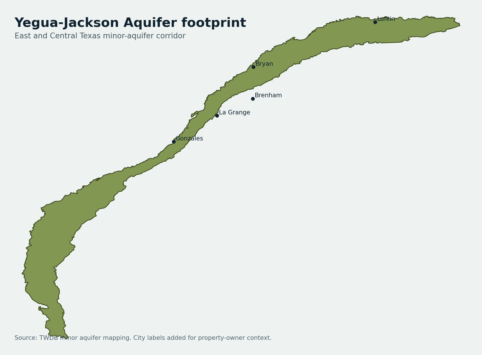
| Texas extent | About 10,932 square miles in the current TWDB minor-aquifer mapping. It covers a long East and Central Texas belt where county averages are often less useful than nearby domestic well records. |
| Aquifer-tagged records | 1,785 GWDB wells tagged exactly Yegua-Jackson, with 1,680 usable depth values. |
| Overall depth range | Median about 264 feet, with the middle half running from about 140 to 411 feet and the 90th percentile near 606 feet. |
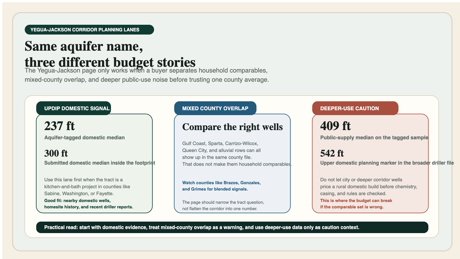
| Domestic-well depth range | 735 aquifer-tagged domestic rows with a 237-foot median and a middle band of about 125 to 330 feet. |
| Stock-well depth range | 237 stock rows with a 235-foot median. That keeps the aquifer grounded in ranch and acreage use, not just city supply. |
| Public-supply depth range | 182 public-supply rows with a 409-foot median and a much wider upper-end tail than most household projects should use as a default budget. |
| Submitted driller-report domestic signal inside the mapped footprint | 6,406 domestic rows with a 300-foot median total depth and a 542-foot upper planning marker. |
| Main planning risk | Mixed county groundwater stories. Yegua-Jackson often overlaps counties where Gulf Coast, Sparta, Queen City, Carrizo-Wilcox, or alluvial signals also show up and can distort the wrong comparison set. |
| Main water-quality watchouts | Iron, manganese, color, lower pH, and rising dissolved-solids or chloride risk in deeper or downdip lanes. Test the actual well before trusting the aquifer reputation. |
What the Yegua-Jackson Aquifer Actually Is
The Yegua-Jackson is a minor aquifer in the Texas coastal plain, but that label can be misleading if you hear “minor” and assume it is a minor property decision. For land buyers and existing well owners, the practical point is not the size label. The practical point is that the aquifer is built from repeated coastal-plain deposition: interbedded sands, silts, clays, and lignite-rich intervals that do not deliver one simple statewide water story. A Yegua-Jackson tract should be treated like a layered groundwater file, not like a single clean rock unit.
That layered geology is why nearby well logs can look repetitive and still hide important differences. One domestic well may finish in a shallower sand package with manageable household water. Another tract nearby may rely on a deeper or more municipal-style interval. A third tract may sit in a county where the most visible groundwater discussion is really about a different aquifer or a river-alluvium slice. This is a page where local records are critical because the geology invites confusion.
It also explains why the Yegua-Jackson is easy to misread in public data. In plenty of counties, the aquifer shares attention with Gulf Coast tags, Sparta tags, Carrizo-Wilcox tags, or Brazos River Alluvium tags. That does not make the Yegua-Jackson unimportant. It means the page is best understood as a corridor that helps you ask better questions about a tract, not as a magic label that answers every depth and quality question by itself.
Why Buyers Get Burned by Mixed County Signals
The biggest Yegua-Jackson problem is not usually “nobody knows anything.” It is the opposite. Too many people know one partial thing and then use that one partial thing as though it solves the property. Somebody quotes a county average without sorting use. Somebody points to a deep city or public-supply well and calls it comparable to a two-bath rural house. Somebody else grabs a shallower domestic example from the wrong side of the county and sells the tract like every nearby well should behave the same way. All three mistakes are common in mixed coastal-plain groundwater counties.
The database backs that up. The exact Yegua-Jackson sample is not tiny. It contains 1,680 usable depth rows. But even inside that clean aquifer-tagged lane, use type changes the story fast. Domestic wells center around 237 feet. Stock wells sit close by at 235 feet. Public-supply wells jump to 409 feet, and irrigation rows push deeper again with a median near 364 feet. That means a buyer who blends all nearby wells together can create a budget that belongs to nobody’s actual project.
The county mix makes the risk worse. Yegua-Jackson counties do not line up into one clean shallow group or one clean deep group. Fayette reads differently from Grimes. Sabine reads differently from Brazos. Gonzales reads differently from Washington. Even when the aquifer tag is the same, the actual tract can sit in a county where river-bottom influence, mixed aquifer labels, deeper public-use records, or a stronger rural domestic history all change what the right comparable set should be.
What the TurnkeyWells Record Shows About Yegua-Jackson Depth
Across the aquifer-tagged GWDB sample, the Yegua-Jackson carries a median depth of about 264 feet, with the middle half running from roughly 140 to 411 feet. The 90th percentile is about 606 feet. That is already enough spread to punish one-number budgeting. A property owner who uses only the median will under-budget some tracts and overreact to others.
The use split is the more useful lens. Domestic aquifer-tagged wells show a median near 237 feet, with a middle band of about 125 to 330 feet. Stock wells stay close, which helps explain why the aquifer often feels workable on ranch and rural-residential land when the comparison set is honest. Public supply is deeper. Irrigation is deeper. Unused or legacy rows spread wider still. This is exactly the type of aquifer where intended use outweighs the county headline.
The driller-report footprint data tells a similar story from a broader field sample. Inside the mapped Yegua-Jackson footprint, TurnkeyWells finds 6,406 domestic submitted driller-report rows with a 300-foot median total depth, a middle band of roughly 200 to 416 feet, and a 90th-percentile planning marker near 542 feet. Domestic pump-depth rows are fewer, but still useful enough to show a 160-foot median pump setting inside the corridor.
Record Snapshot
The Yegua-Jackson is a comparison-set aquifer. Most bad budgets here come from mixing the wrong wells together, not from a total lack of public data.
County Yegua-Jackson Snapshots
County snapshots are useful only when they keep you honest. They are not promises. They are guardrails that show why a Yegua-Jackson tract in one county may behave very differently from a Yegua-Jackson tract in another. The table below uses aquifer-tagged usable depth rows and keeps the emphasis on how each county should be read, not just how its numbers look on a spreadsheet.
| County | Record density | Depth signal | Main use in exact sample | How to read it |
|---|---|---|---|---|
| Fayette County | 198 aquifer-tagged depth rows | 271 ft avg / 200 ft median | Domestic | A balanced east-central Texas sample where domestic evidence is strong and the aquifer still behaves like a layered tract-by-tract planning problem rather than a one-depth county. |
| Angelina County | 202 aquifer-tagged depth rows | 313 ft avg / 255 ft median | Domestic | A stronger East Texas domestic slice that keeps the page honest about timber-country wells, mixed sand packages, and the overlap with other East Texas aquifer names. |
| Brazos County | 184 aquifer-tagged depth rows | 354 ft avg / 300 ft median | Domestic | Useful because it sits in a mixed groundwater county where Brazos alluvium, Sparta, and Yegua-Jackson all compete for attention. Buyers here need the right comparable set fast. |
| Burleson County | 142 aquifer-tagged depth rows | 339 ft avg / 300 ft median | Domestic | A good example of how Yegua-Jackson can share the page with alluvium, Queen City, Sparta, and Carrizo-Wilcox, which makes county averages dangerous when used lazily. |
| Grimes County | 107 aquifer-tagged depth rows | 365 ft avg / 342 ft median | Domestic | A county where Yegua-Jackson is meaningful but not alone. Helpful for showing the deeper, layered side of the corridor that can look very different from a shallower East Texas tract. |
| Gonzales County | 116 aquifer-tagged depth rows | 276 ft avg / 214 ft median | Domestic | Shows the south-central transition where Yegua-Jackson, Sparta, Queen City, and Carrizo-Wilcox can all influence the same county file and force buyers back to nearby domestic wells. |
| Sabine County | 90 aquifer-tagged depth rows | 245 ft avg / 168 ft median | Domestic | One of the cleaner East Texas Yegua-Jackson domestic reads. Useful for private-well buyers who need a less metro-distorted picture of the aquifer. |
| Washington County | 72 aquifer-tagged depth rows | 353 ft avg / 289 ft median | Domestic | A practical corridor county where Gulf Coast and Yegua-Jackson signals overlap and tract position carries more weight than county folklore. |
Fayette is a useful anchor because it behaves like a practical central-Texas Yegua-Jackson county without pretending the whole corridor is shallow. Angelina and Sabine help on the East Texas side because they keep the page grounded in private-well and timber-country reality. Brazos, Burleson, and Grimes show how quickly mixed groundwater counties complicate the story. Gonzales and Washington prove that the same aquifer label can still sit inside a deeper multi-aquifer county conversation where the domestic comparison set carries more weight than the county badge.
Water Quality: Where the Yegua-Jackson Turns Into a Real Ownership Question
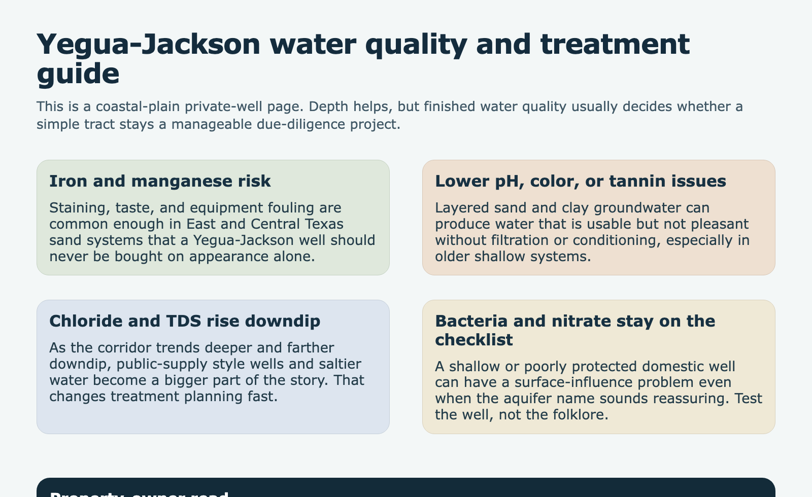
Aquifer pages get misread when buyers focus only on depth. The Yegua-Jackson is a good example. A domestic depth that looks manageable on paper can still produce water that needs treatment or tighter maintenance than the buyer expected. Iron and manganese are common enough in East and Central Texas groundwater systems that staining, taste, and equipment fouling belong in the conversation early. A shallow domestic well that looks financially friendly can still become an ownership hassle if nobody tested the actual water.
Color, lower pH, and organic influence are relevant too. In layered coastal-plain sands and clays, a well can technically be “good water” and still be water the owner does not enjoy living with. That does not mean the aquifer is bad. It means the right question is not “is Yegua-Jackson water good?” The right question is “what does this well test show on this tract, at this depth, with this completion and this maintenance history?”
As the corridor trends deeper or farther downdip, total dissolved solids and chloride risk become more important. Public-supply style wells and deeper mixed-use county files are part of the reason the aquifer-tagged public-supply median is so much higher than the domestic median. That deeper water is not a household death sentence, but it does mean a buyer should treat chemistry as part of the budget and not as a surprise for after closing.
The safest habit is testing. If the property already has a well, get a current panel instead of trusting old assumptions. If the well is older, shallow, or poorly protected at the surface, bacteria and nitrate still need attention. If the county file trends deeper, iron, manganese, chloride, sulfate, and dissolved solids deserve attention. The aquifer name narrows the list. The lab result settles the question.
Groundwater Districts and Local Oversight
The Yegua-Jackson corridor does not live under one single groundwater rulebook. That is one more reason the page cannot be reduced to a county average or a driller anecdote. Some properties will be straightforward domestic-well conversations. Others will sit in counties where the district answer, the intended use, or the spacing and registration lane carries far more weight than the buyer expected. The mistake is assuming the county name alone settles the rule question.
That is why the first tool is not a drill quote. It is the Free GCD Lookup. Run the tract through the district answer before you price the well. If the intended use is domestic or livestock, the parcel may still have rules that apply. If the planned use is commercial, irrigation, or higher volume, that difference can change the timing and paperwork in a way that no county average will warn you about.
Mixed groundwater counties make this even more important. A buyer who already has to sort Yegua-Jackson from Gulf Coast, Sparta, Carrizo-Wilcox, or river-alluvium noise does not need a second blind spot on the regulatory side. TurnkeyWells uses the district result and the nearby well record together because each one corrects a different kind of bad assumption.
Buying Property With an Existing Yegua-Jackson Well
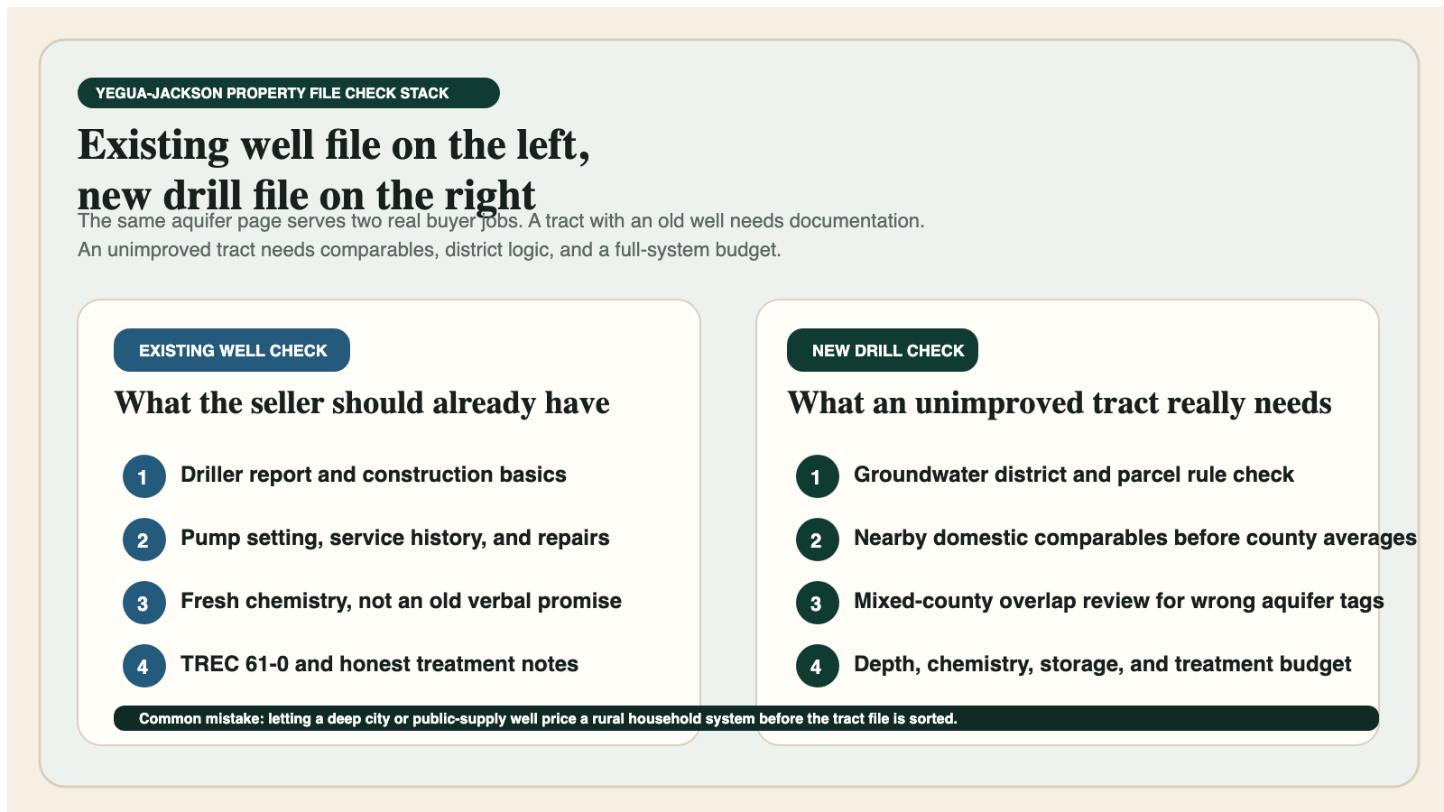
If the property already has a well, the first question is not whether the pump starts when you flip the switch. The first question is whether the record, test history, and nearby comparable wells support the story the property is being sold with. A functioning private well can still be poorly documented, poorly protected, or paired with chemistry that changes the household budget after closing. A Yegua-Jackson property should be evaluated like an asset with documentation needs, not like a mystery box that hopefully keeps working.
Ask for the driller report if it exists. Ask for service history, pump-setting information, and treatment-equipment notes. Ask for the most recent water-quality test. If the test is old or thin, budget for a new one while the deal still has contingency room. A seller saying “we never had a problem” is not evidence. It is a sentence. On a layered coastal-plain aquifer page, sentences do not replace records.
The seller side deserves attention too. A seller who already has the file, the test, and a realistic description of the system usually closes with less drama. That is especially true if the transaction involves TREC Form 61-0. Clean well history, district context, and honest water-quality documentation reduce the chances that the groundwater conversation turns into a last-minute negotiation about something that should have been known all along.
Planning a New Yegua-Jackson Well
A new Yegua-Jackson well should start with comparable domestic or intended-use evidence, not with the deepest dramatic well somebody found online and not with the shallowest lucky hit somebody remembers from ten years ago. The safer planning sequence is: confirm the district, sort nearby domestic wells, understand whether the tract sits in a mixed groundwater county, and then let the deeper public-supply or irrigation history act as context instead of as the household budget model.
The encouraging part of the page is that the domestic signal is real. aquifer-tagged domestic rows center around 237 feet, and the driller-report domestic sample inside the mapped footprint centers around 300 feet. That does not guarantee a tract. It does mean the aquifer has a real household-well pattern when the comparison set is honest. Buyers should use that honest pattern first, then widen out to the more mixed county story only after the household baseline is understood.
The caution part is that the upper tail is real too. A 90th-percentile domestic planning marker near 542 feet is not there for decoration. Some tracts will run harder, deeper, or more treatment-heavy than the median suggests. That is why TurnkeyWells treats the Pre-Drill Intelligence Report as the right next step when a Yegua-Jackson property moves from casual interest to real money. The cost of getting the comparison set wrong is usually much higher than the cost of doing the record work first.
Relevant Live County Pages in the Yegua-Jackson Corridor
Useful county examples in the Yegua-Jackson corridor include Fayette County, Brazos County, Burleson County, Grimes County, Gonzales County, Washington County, and Sabine County. Those pages help because they show how the corridor changes from one county to the next instead of pretending the aquifer is uniform.
Just as important are the counties this page does not force. Some Yegua-Jackson counties also sit in stronger Gulf Coast, Sparta, Carrizo-Wilcox, or alluvial narratives. A county only belongs here when the aquifer relationship is real enough to help a property owner rather than just pad the interlink count. Accuracy beats filler on aquifer pages.
How the Yegua-Jackson Compares With Other TurnkeyWells Aquifer Guides
The Yegua-Jackson is not the same planning problem as the Gulf Coast Aquifer, even though the two often show up in overlapping counties and broader coastal-plain conversations. The Gulf Coast page is more dominated by the Chicot, Evangeline, Jasper, coastal salinity, and metro pumpage story. The Yegua-Jackson page is more about mixed county signals, domestic comparison discipline, and layered tract-by-tract sand packages inside a long inland corridor.
It is also not the same as the Carrizo-Wilcox Aquifer, where deeper sand targets and a different regional development story often shape the budget. Nor is it the same as the Trinity Aquifer, where North Texas limestone and sandstone behavior changes the whole groundwater conversation. The Yegua-Jackson has its own personality: mixed counties, honest domestic evidence, and a constant need to separate the right wells from the impressive but wrong ones.
How TurnkeyWells Helps on a Yegua-Jackson Property
The Free Well Check is the fast first pass. It helps you see whether a Texas address already has nearby registered wells and whether the local record feels sparse, dense, shallow, deep, or mixed. On a Yegua-Jackson tract, that first look often reveals whether the property sits in a strong domestic-well pattern or in a county where the comparison set needs more discipline.
The Pre-Drill Intelligence Report is the stronger next move when a tract is real enough to budget. It organizes the nearby record, use mix, aquifer context, and local risk so a buyer does not price a rural domestic well from a public-supply or legacy well pattern. That carries more weight on this aquifer than on pages where one dominant county story does most of the work.
The Free GCD Lookup closes the rule gap. On Yegua-Jackson properties, the best outcome usually comes from doing those three steps in order: tract record, district answer, then deeper budget decisions. The page gets dramatically less mysterious once the workflow is clean.
Frequently Asked Questions About Yegua-Jackson Wells in Texas
How deep is a typical Yegua-Jackson private well in Texas?
There is no single statewide number, but the domestic aquifer-tagged sample centers around 237 feet and the domestic driller-report sample inside the mapped footprint centers around 300 feet. Some tracts will run shallower, and some will run meaningfully deeper, especially in mixed or downdip counties.
Is Yegua-Jackson water good?
Sometimes yes, but not by reputation alone. Iron, manganese, color, lower pH, and in deeper corridors higher dissolved solids or chloride can all change the treatment story. Test the actual well instead of assuming the aquifer name settles the question.
Why do some Yegua-Jackson counties look much deeper than others?
Because the corridor crosses mixed groundwater counties, different use types, and different positions in the coastal-plain sequence. A Sabine County domestic well and a deeper public-supply style well in another county can both be Yegua-Jackson wells without telling the same household-budget story.
What is the easiest mistake to make on a Yegua-Jackson property?
Using the wrong comparable wells. Buyers often mix domestic, public-supply, irrigation, unused, and other aquifer tags together. On this page, sorting the right local domestic evidence is usually the difference between a sound plan and an expensive one.
The Bottom Line on the Yegua-Jackson Aquifer in Texas
The Yegua-Jackson is not an aquifer that rewards shortcuts. It is a useful, real-world groundwater corridor for Texas property owners, but only when it is read as a layered, mixed-county, use-specific planning problem. The safe play is simple: verify the district, sort the nearby domestic wells, test the actual water, and budget the full system instead of just the drill hole. That is competent due diligence, not overkill.
That is exactly where TurnkeyWells helps. Start with the Well Check, confirm the district, and use the Pre-Drill report before you trust the wrong county average or the wrong impressive well nearby. On a Yegua-Jackson tract, that discipline is what keeps an ordinary rural property decision from turning into a correction project.