North and Northeast Texas groundwater planning
The Woodbine Aquifer in Texas
A practical guide to Woodbine depth shifts, iron and salinity risk, groundwater district rules, and how to avoid using the wrong North Texas wells as your property budget baseline.
The Woodbine Aquifer is one of those Texas aquifers that gets oversimplified in both directions. Some buyers hear “North Texas sandstone” and assume they are dealing with a moderate rural household well. Others hear city-supply depths out of Dallas, Grayson, or Fannin County and assume every Woodbine tract is a deep, expensive, nearly municipal project. Both shortcuts are lazy. The Woodbine is a minor aquifer, but it is not a minor planning problem.
For property owners, the real Woodbine story is transition. On the western and updip side of the aquifer, household and irrigation wells can look manageable compared with the deeper public-supply record farther east and northeast. Move downdip, and the same aquifer name starts carrying deeper finished depths, more public-supply noise, more unused legacy rows, and a bigger water-quality question. That is why a single county average or one dramatic well story can misprice a tract fast.
This guide is built for buyers, sellers, ranch owners, rural homeowners, agents, and small developers who need something more useful than a geology label. It combines current Texas Water Development Board Woodbine facts with TurnkeyWells groundwater records and the official aquifer footprint so you can see what the Woodbine is, where it sits, how it changes from the rural fringe to the deeper downdip corridor, where water quality can get ugly, and how TurnkeyWells tools help before you drill or buy on a bad assumption.
Quick Facts About the Woodbine Aquifer in Texas
| Planning item | Practical property-owner meaning |
|---|---|
| Aquifer type | Minor sandstone aquifer that overlies the Trinity, with shale and clay breaks that create three main water-bearing Woodbine zones |
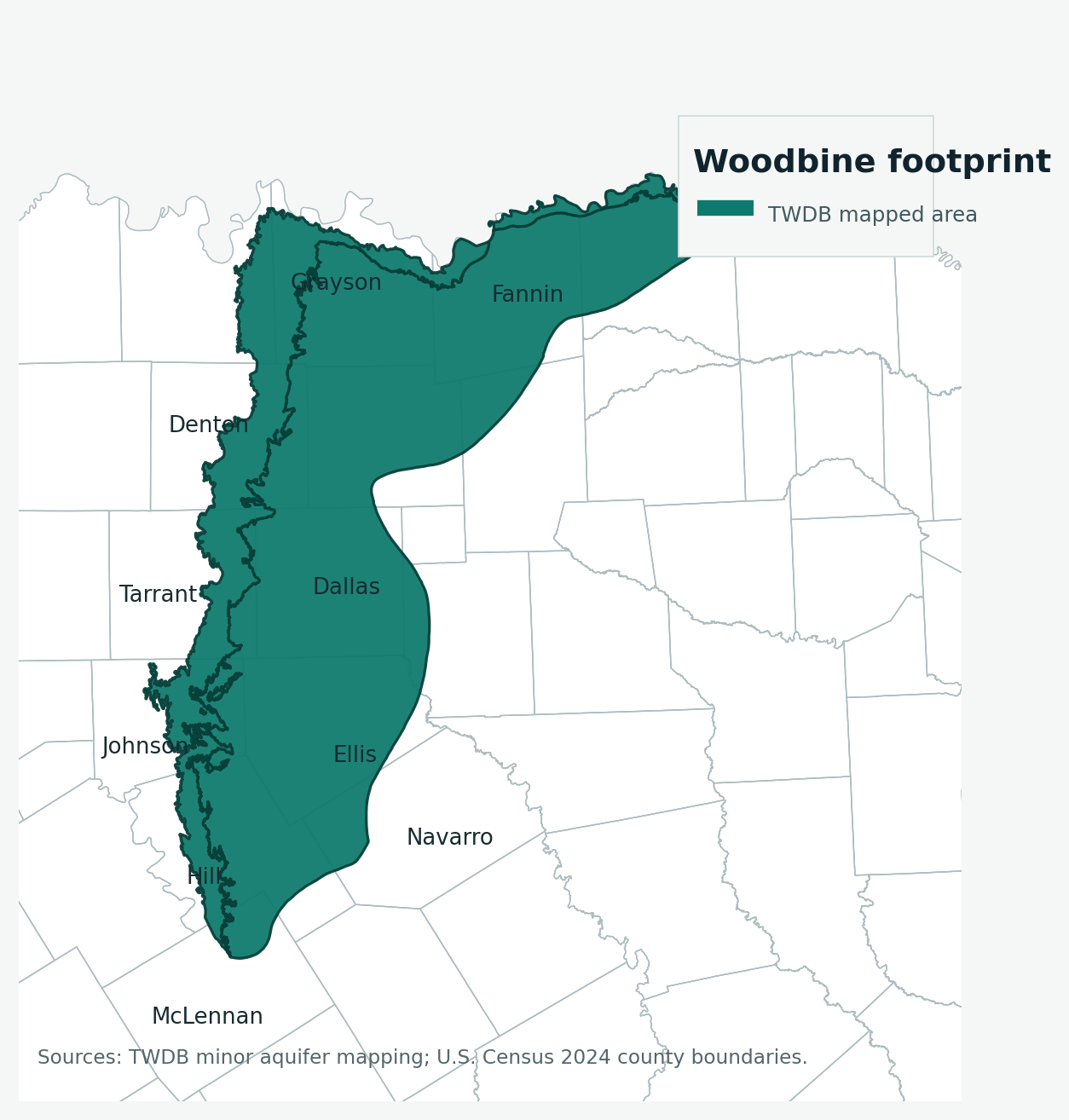
| Texas extent | 1,561 square miles of outcrop and 5,784 square miles in subsurface across 17 North and Northeast Texas counties |
| Groundwater district coverage | About 73 percent of the aquifer sits inside groundwater conservation district jurisdiction |
| Thickness signal | The Woodbine reaches about 600 feet thick in subsurface areas, while freshwater saturated thickness averages about 160 feet |
| TurnkeyWells exact Woodbine-tagged sample | 1,409 GWDB rows, with 1,394 carrying usable depth values |
| Typical exact-tag depth signal | Median about 440 feet, with the middle half about 250 to 990 feet and the 90th percentile near 1,433 feet |
| Domestic exact-tag depth signal | Median about 301 feet, with the middle half about 232 to 654 feet |
| Submitted driller-report domestic total-depth signal inside the official footprint | 4,066 domestic rows with a 275-foot median and a 810-foot upper planning marker |
| Main water-quality warnings | Upper-zone iron problems, fresh water usually to about 1,500 feet, and a deeper slightly to moderately saline lane that often runs about 1,000 to 4,000 mg/L TDS |
| Common bad comparison | Blending deep city-supply Woodbine or metro monitor rows with a rural domestic homesite budget |
What the Woodbine Aquifer Actually Is
The Texas Water Development Board describes the Woodbine as a minor aquifer in northeast Texas that overlies the Trinity Aquifer and consists of sandstone interbedded with shale and clay. For property owners, that tells you two useful things right away. First, this is not a simple open sand body that behaves the same from one county to the next. Second, the Woodbine sits in conversation with other North Texas groundwater systems, which is one reason local wells can show such a broad range of depth, yield, and water-quality outcomes.
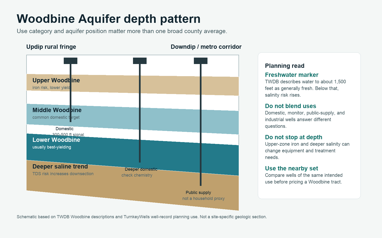
TWDB says the aquifer forms three distinct water-bearing zones. That matters because “Woodbine” on a well record does not always mean the same production interval, the same yield quality, or the same treatment burden. The lower zones generally yield the most water. The upper zone can produce much less and often runs high in iron. That one fact should already change how you think about a shallow Woodbine well. Hitting water is not the same as hitting the right water.
The Woodbine also reaches deeper and behaves differently as you move into the subsurface side of the aquifer. TWDB says it can reach about 600 feet thick in the subsurface, while freshwater saturated thickness averages about 160 feet. That is a helpful statewide framing number, but it is not a finished-depth quote. It is a reminder that the Woodbine can support meaningful supply while still punishing people who assume one tract behaves like the next one over.
The History of the Woodbine Aquifer in Texas
The Woodbine is not just a rural homesite aquifer. It has a long North Texas utility history, especially where deeper municipal and industrial wells became part of the growth story. That matters because old city-supply and legacy unused records still sit in the data, and they can distort how a property buyer reads the aquifer if he mistakes them for comparable household evidence.
On the western and updip side of the Woodbine, the aquifer has also served rural landowners, livestock operations, irrigation users, and scattered domestic well projects for years. That is why the page should never be read as “Woodbine equals deep city water only.” It is more accurate to say the aquifer has two public reputations at once: a rural fringe supply story and a deeper downdip public-supply story. Both are real. The mistake is pretending they are interchangeable.
That split historical use still shapes the modern record. When TurnkeyWells looks at the official Woodbine footprint, it finds heavy monitor and environmental-soil-boring noise in the metro corridor, thousands of domestic and irrigation records that matter more to rural buyers, and a large plugged-well history that proves this is not a static or untouched groundwater lane. The Woodbine has been worked hard enough that the best project today starts with real evidence, not folklore.
What TurnkeyWells Records Show About Woodbine Well Depth
The cleanest statewide Woodbine count in the TurnkeyWells database comes from exact GWDB tags. There are 1,409 rows tagged exactly Woodbine, and 1,394 of those have a usable depth value. Across that exact-tag sample, the average depth is about 653.4 feet and the median is about 440 feet. The middle half runs from roughly 250 to 990 feet, and the 90th percentile lands near 1,433 feet.
Those broad numbers are useful, but they hide the real planning split. Exact-tag domestic wells show a median near 301 feet. Irrigation wells show a median near 255 feet. Stock wells sit around 520 feet. Public-supply wells jump to a median around 870 feet, and industrial rows sit near 589 feet. That spread is the whole Woodbine story in one table. Rural private use and deep municipal or industrial use are not the same budget problem.
The official-footprint driller report adds a second, and in many ways more practical, check. Inside the Woodbine footprint, TurnkeyWells finds 47,428 submitted driller reports and 34,017 plugged-well records. But the biggest buckets inside that footprint are not the ones a land buyer usually expects. Monitor wells account for about 23,192 rows, environmental soil borings add about 13,519, domestic wells contribute about 4,067, and irrigation wells contribute about 3,029. In other words, the raw Woodbine footprint record is loaded with non-comparable metro and infrastructure noise.
That is exactly why the domestic subset matters. Submitted domestic driller reports inside the official Woodbine polygon show 4,066 usable total-depth rows with a median around 275 feet, a middle band of roughly 170 to 540 feet, and a 90th-percentile planning marker near 810 feet. Domestic pump settings inside the footprint show a median around 220 feet. That is much more useful than letting monitor wells and deep city wells poison the household planning number.
Representative county depth table
| County | Exact-tag sample | Average / median depth | Dominant use in sample | Planning read |
|---|---|---|---|---|
| Tarrant County | 154 exact-tag depth records | 175 ft avg / 178 ft median | Irrigation | Western Woodbine edge with many irrigation and estate-style wells. Useful for rural buyers near the outcrop belt, but not a stand-in for deeper municipal Woodbine country. |
| Johnson County | 132 exact-tag depth records | 231 ft avg / 237 ft median | Domestic | One of the cleaner domestic planning counties in the exact tag sample. Good reminder that the Woodbine can serve households without Dallas-depth numbers everywhere. |
| Hill County | 74 exact-tag depth records | 437 ft avg / 344 ft median | Unused | A transition county where the spread gets wider fast. This is the kind of place where one nearby well is not enough evidence. |
| Dallas County | 229 exact-tag depth records | 750 ft avg / 750 ft median | Unused | Public-supply and unused legacy noise dominate. Helpful for showing how deep downdip Woodbine can become, but weak as a proxy for a rural homesite. |
| Ellis County | 206 exact-tag depth records | 873 ft avg / 840 ft median | Domestic | A deeper domestic corridor. This is where the Woodbine stops feeling like a shallow fringe aquifer and starts looking like a serious finished-depth project. |
| Denton County | 145 exact-tag depth records | 340 ft avg / 301 ft median | Public Supply | Mixed public-supply and private-use signal. Good proof that the same aquifer can tell very different stories a county or two apart. |
| Grayson County | 227 exact-tag depth records | 647 ft avg / 496 ft median | Public Supply | North Texas municipal and industrial pressure shows up clearly here. Buyers should separate city-scale records from household planning. |
| Fannin County | 80 exact-tag depth records | 1,190 ft avg / 1,285 ft median | Public Supply | One of the deeper downdip examples in the exact tag sample. Useful for killing the lazy idea that Woodbine always means an affordable household well. |
The spread in that county table is not background detail. It is the planning lesson. Tarrant and Johnson look far more like workable rural-fringe Woodbine. Hill already warns you that the spread widens. Dallas, Ellis, Grayson, and Fannin show the downdip side where deeper public-supply and legacy rows make the aquifer feel like a very different project. The aquifer name is the same, but the property decision is not.
Why the Woodbine Confuses Buyers More Than They Expect
The first trap is depth envy. Someone finds a shallow western-edge Woodbine well and assumes the next tract over should pencil the same way. The second trap is city panic. Someone sees a deep municipal Woodbine record in Dallas, Grayson, or Fannin County and assumes every Woodbine property is a giant finished-depth project. Both mistakes come from the same bad habit: treating unlike wells as though they are comparable.
The Woodbine is especially vulnerable to this because the footprint runs through the northern growth corridor where private wells, city systems, industrial use, monitor wells, and environmental borings all share space. That kind of data environment can fool people who have just enough public information to be dangerous. A median from the wrong use bucket is not better than no median at all.
The safer approach is simple. Sort the local records by intended use first. Ask whether the nearby evidence is domestic, irrigation, stock, or city-scale public supply. Then ask where the tract sits in the aquifer trend. Is it closer to the rural fringe where Woodbine depths look manageable, or closer to the deeper downdip corridor where the finished-depth and chemistry story can get more expensive? That sequence beats a broad county average every time.
Water Quality: The Part of the Woodbine People Skip at Their Own Expense
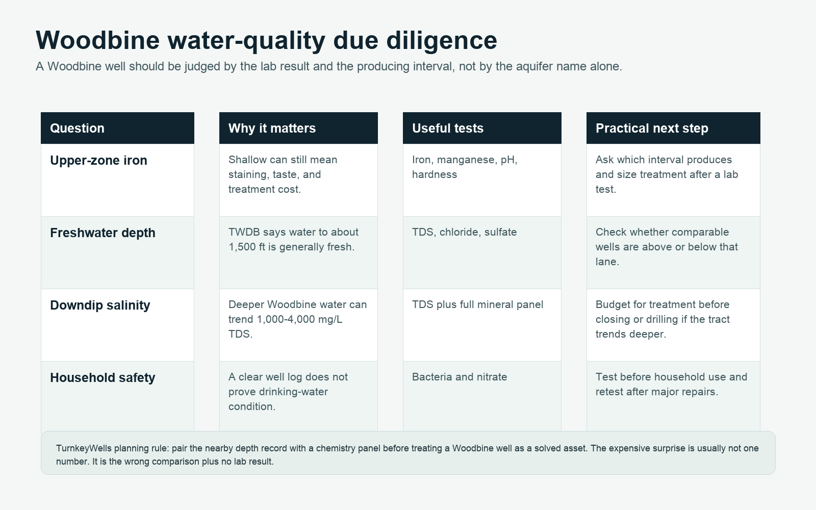
TWDB says the lower Woodbine zones usually yield the most water, while the upper zone tends to yield limited water that is often very high in iron. That is a direct practical warning. If somebody tells you he has a shallower Woodbine hit, your next question should not just be “how much water?” It should be “from which Woodbine zone, and what does the lab say?” An iron-heavy upper-zone well can become a treatment and equipment headache even if the depth looked friendly.
TWDB also says water to a depth of about 1,500 feet is generally fresh and contains less than 1,000 milligrams per liter of total dissolved solids. Below that depth, water becomes slightly to moderately saline, commonly running about 1,000 to 4,000 milligrams per liter TDS. For a property owner, that means the deeper Woodbine conversation is not only about drilling depth. It is about whether the deeper interval still fits a domestic treatment budget.
The chemistry panel for a Woodbine domestic well should at least include bacteria, nitrate, iron, manganese, pH, hardness, chloride, sulfate, and total dissolved solids. If the tract trends deeper or farther downdip, the salinity question gets more important, not less. If the well appears to be pulling from a shallower upper-zone interval, iron deserves real attention instead of a shrug.
This is why the Woodbine can punish buyers who think a well log closes the file. The log tells you what somebody drilled. The lab tells you what somebody lives with. If a deal depends on an existing well, the chemistry result belongs in the due-diligence stack before closing, not after the keys change hands.
Groundwater Districts and Permitting Reality
TWDB says about 73 percent of the Woodbine sits inside groundwater conservation district coverage. That should end the fantasy that the permitting or registration side is just a minor afterthought because the aquifer runs under urbanized North Texas. Domestic exemptions may exist on some tracts, but spacing, notice, registration, and use-based rules can still matter, especially where growth pressure is real.
The first move is still simple: run the Free GCD Lookup on the actual property. Do it before you let a driller quote become your working truth. District rules do not replace geology, but they absolutely change timeline, spacing assumptions, and whether a plan that sounded easy at the kitchen table still works on paper.
The second move is to confirm whether the nearby record you are using is actually the right comparison set. A district lookup plus nearby domestic Woodbine evidence is far more useful than a permit conversation built on a public-supply well, a monitor record, or an old unused city row. On the Woodbine, bad sequence is half the risk.
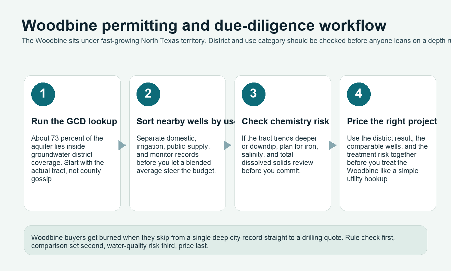
Check the Rules and the Right Wells Before You Drill
The Woodbine can look moderate on one tract and deep or treatment-heavy on the next. Confirm the district, the comparable domestic wells, and the chemistry risk before you price the project like a generic North Texas well.
What This Means When Buying Land With an Existing Woodbine Well
An existing Woodbine well can be a real asset, but only if you know which version of the Woodbine story it represents. Ask for the driller report if it exists, the pump setting if anybody knows it, a recent lab test, and a clean explanation of how the well has actually been used. A stock or irrigation well proves something about supply, but it does not automatically answer the domestic question cleanly. A public-supply row nearby proves something about aquifer capability, but not necessarily about household cost.
This is also where transaction discipline matters. If a seller is completing TREC Form 61-0, the cleaner deal is the one where the district, the well record, and the water-quality condition are already documented before everybody starts improvising in escrow. On the Woodbine, documentation beats storytelling because the record is too mixed to trust a simple verbal summary.
For household buyers in western Woodbine territory, the main risk is usually using the wrong comparison set. For deeper downdip buyers, the main risk is underestimating finished depth or water-quality burden. Either way, the file gets stronger when the well record and the lab test match the actual intended use of the tract.
What This Means When Drilling a New Woodbine Well
A new Woodbine well should start with comparable domestic or intended-use evidence, not with the deepest dramatic record somebody found online. In practical terms, that means pulling nearby wells, sorting out public-supply and monitor noise, checking the district, and then deciding whether the tract behaves more like Tarrant or Johnson County Woodbine, more like transitional Hill County Woodbine, or more like the deeper Ellis to Fannin downdip corridor.
The upside is real. The Woodbine can support domestic, livestock, irrigation, municipal, industrial, and small-system use. TWDB says it already does. The downside is that this usefulness spans a broad depth and chemistry range. A project can go wrong when somebody sees “Woodbine” and assumes the aquifer name alone has already solved the budgeting question.
The smartest Woodbine budget includes drilling depth, pump setting, surface equipment, and at least the possibility of treatment. If the tract is in a shallower fringe position, the treatment question may center on iron. If the tract trends deeper or more downdip, total dissolved solids and salinity become more important. Either way, pricing the job before you understand that distinction is how a moderate project becomes a correction project.
Current TurnkeyWells County Links in Woodbine Country
TurnkeyWells should only link county pages here when the county page is both live and genuinely relevant to the Woodbine story. One current verified county page that fits the western Woodbine edge is Water Well Drilling in Hill County, TX. Hill County matters because it shows the transition zone where Woodbine depth spreads widen and a one-well comparison starts getting risky.
That restraint is deliberate. The Woodbine touches a broader North Texas county set, but forcing the wrong county links into this hub just to hit a quota would make the page worse, not better. As more truly relevant Woodbine county pages are published and verified, they can belong here. Until then, accuracy beats filler interlinking.
How the Woodbine Compares to Other Texas Aquifers
The Woodbine is not the same planning problem as the Trinity Aquifer. The Trinity conversation around DFW is more dominated by limestone and sandstone recharge behavior across a different regional geometry. The Woodbine is more zone-specific, more sensitive to upper-zone iron versus deeper salinity, and more likely to be misread because of the public-supply and monitor noise embedded in its corridor.
It is also not the same as the Gulf Coast Aquifer, where stacked coastal sands, municipal depth inflation, and saltwater encroachment shape the story. And it is not the same as the Ogallala Aquifer, where High Plains depletion and saturated-thickness decline dominate the risk narrative. The Woodbine has its own personality: North Texas transition, zone-dependent yield, metro-noise distortion, and chemistry that changes with depth.
How TurnkeyWells Helps on Woodbine Properties
The Woodbine is exactly the kind of aquifer where public information exists in volume but easy interpretation does not. A buyer can pull dozens of well records and still get the wrong answer if he blends domestic, public-supply, irrigation, monitor, and unused rows into one pile. That is why TurnkeyWells focuses on turning the record into something you can actually use for a property decision.
The Free Well Check is the fast start. It shows nearby registered wells at a Texas address so you can see whether the local pattern looks like rural domestic Woodbine, irrigation Woodbine, deep public-supply Woodbine, or a data mix too noisy to trust without more work. The Pre-Drill Intelligence Report goes farther by organizing the nearby record, the aquifer context, and the local risk into a tract-focused planning view. And the Free GCD Lookup confirms who governs the property before you assume anything about registration, spacing, or exemptions.
Research the Property Before You Commit
On the Woodbine, the expensive mistake is trusting the wrong well set. Start with the nearby domestic evidence, then layer in the district result and the chemistry risk before you trust a drilling number.
Frequently Asked Questions About Woodbine Wells in Texas
How deep is a typical Woodbine well in Texas?
It depends heavily on where you are in the aquifer and which use category you are reading. In the TurnkeyWells exact Woodbine-tagged sample, the median depth is about 440 feet. Domestic exact-tag wells show a median around 301 feet, while exact public-supply wells sit much deeper around 870 feet.
Is Woodbine water safe to drink?
Sometimes yes, but not by aquifer name alone. The upper zone can run high in iron, and deeper downdip water can shift toward a slightly to moderately saline profile. Test the actual well before relying on it for household use.
Why does the Woodbine record look so noisy?
Because the footprint runs through a metro and growth corridor with heavy monitor, environmental-soil-boring, public-supply, industrial, and unused legacy rows mixed into the same geography. Those are not always valid domestic-well comparisons.
Do I need a permit to drill a Woodbine well?
Sometimes yes, and even where a domestic exemption may apply, registration, spacing, or district-specific rules can still matter. About 73 percent of the aquifer lies under district coverage, so the right answer is parcel-specific. Start with the Free GCD Lookup.
What is the biggest Woodbine mistake buyers make?
Trusting the wrong comparison set. On this aquifer, the bad move is letting a deep city-supply record or a pile of monitor rows stand in for a rural domestic budget, or letting a shallow iron-prone upper-zone well get sold as a complete household answer.
Data and planning language in this guide draw on Texas Water Development Board Woodbine facts, official aquifer mapping, local TurnkeyWells well-record checks, and groundwater district context. Well depth, water quality, yield, and permitting vary by property. This guide is a planning resource for landowners, buyers, sellers, agents, and rural property professionals. It is not a substitute for a licensed water well driller, a water-quality lab, or the applicable groundwater district.